
Zweten in de stad Gent: terreinobservaties versus modellering
- StevenCaluwaerts
- RafiqHamdi
U hebt het waarschijnlijk ook al ondervonden: tijdens een stralende, windstille dag voelt een stedelijke omgeving warmer aan dan het platteland wat verderop. Dit fenomeen waarbij de temperatuur hoger oploopt in de stad wordt het stedelijk hitte-eiland genoemd. Deze hogere stedelijke temperaturen zorgen ervoor dat mensen in de stad meer lijden onder de warmte als zich een hittegolf voordoet. Deze verhoogde temperaturen komen nog eens bovenop de opwarming ten gevolge van klimaatverandering. Hoe kunnen we onze steden hierop voorbereiden? Dit werd onderzocht met behulp van een hoog resolutie weermodel en data van zes weerstations in en rondom Gent.
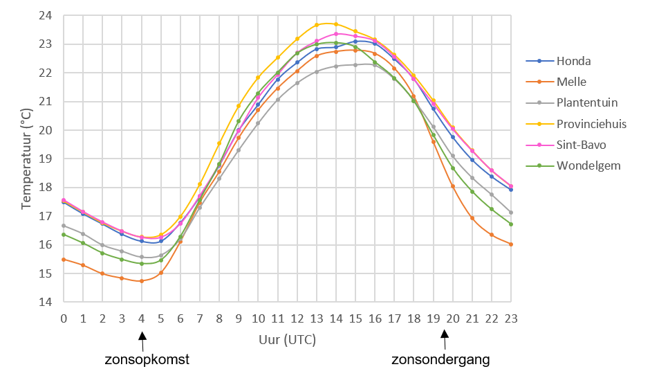
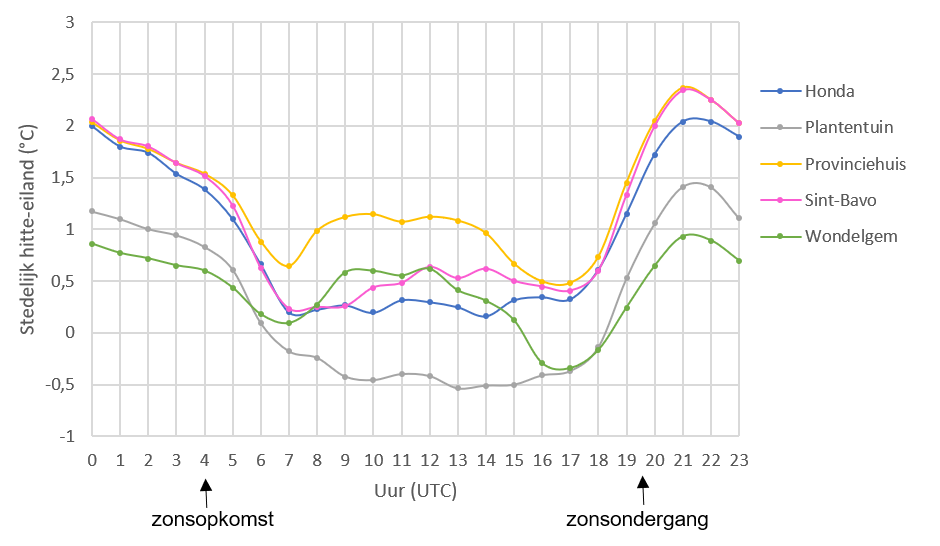
Voorbije zomer lag u misschien, badend in het zweet, zich te ergerden aan het feit dat u niet in slaap kon vallen door de aanhoudende warmte. Dit fenomeen waarbij mensen hinder ondervinden ten gevolge van warmte noemen we hittestress. Voornamelijk kwetsbare groepen, zoals ouderen, ondervinden gezondheidsproblemen bij hittestress. Tijdens hittegolven kan extreme hittestress zelfs leiden tot de dood. Hittestress wordt vaker geobserveerd in steden dan op het platteland door de aanwezigheid van het stedelijk hitte-eiland. Het temperatuurverschil tussen de stad en het platteland is meestal het grootst net na zonsondergang. De mensen in de stad lijden op dat moment nog steeds onder de warmte, terwijl men op het platteland reeds kan genieten van een afkoeling.
De hitte in steden wordt intenser door de combinatie van de groei van steden en klimaatverandering. In het sterk verstedelijkte Vlaanderen is het daarom zeer relevant om te weten hoe we met dit door de mens geïnduceerde fenomeen kunnen omgaan. De levenskwaliteit in steden kan bijvoorbeeld worden behouden of zelfs verbeterd door gebruik te maken van de kennis die we hebben omtrent het stedelijke hitte-eiland fenomeen en de inperking ervan.
 Verschillende factoren spelen een rol bij de temperatuur die we ervaren als we doorheen de straten wandelen. Menselijke activiteit, verharding, hoge gebouwen, smalle straten en de afwezigheid van water en groen zorgen er namelijk voor dat de warmte sterker blijft hangen in de stad dan op het platteland. Doordat stedelijke gebieden warmte langer vasthouden dan hun omgevende rurale gebieden ontstaat het stedelijk hitte-eiland effect. De intensiteit van het stedelijk hitte-eiland is afhankelijk van voorgenoemde factoren en is daarom verschillend op verschillende plaatsen in de stad.
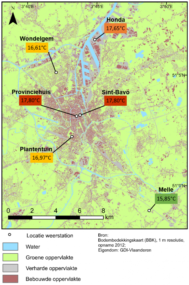 Deze variabiliteit in temperatuurverschillen wordt op vandaag in kaart gebracht met de weerstations van het MOCCA netwerk (Monitoring the City’s Climate and Atmosphere) te Gent. De temperatuurvariaties op dergelijke lokale schaal worden echter niet voorspeld door weermodellen die momenteel worden gebruikt voor onze weerberichten. Dit komt doordat een weermodel een vereenvoudiging is van de alles wat zich in de atmosfeer afspeelt om zo de tijdsduur van de berekeningen te beperken.
Er wordt echter heel wat onderzoek gedaan om die interactie tussen de stad en het weer in rekening te kunnen brengen bij weermodellen. De moeilijkheid hierbij is dat een weermodel de kenmerken van de stadsomgeving gedetailleerd moet kennen. Om stedelijke effecten te integreren in weersvoorspellingen is een weermodel met een hogere ruimtelijke resolutie nodig. Dit wil zeggen dat er een dichter netwerk van punten wordt gebruikt waarin berekeningen worden gedaan. Een dichter netwerk betekent meer punten en dit betekent op zijn beurt een langere rekentijd. Om de rekentijd te beperken moet zo’n hoge resolutie voorspelling tot een kleiner gebied beperkt worden. Je kan het voorgaande vergelijken met een digitale foto: hoe meer pixels, hoe hoger de resolutie en hoe gedetailleerder de foto, maar voor een gedetailleerdere foto heb je meer tijd en opslagcapaciteit nodig om de foto over te zetten op je computer.
Simulaties met een hoog resolutie weermodel werden gebruikt voor de zomer van 2016 om na te gaan of bepaalde veranderingen in het model zorgden voor een betere of slechtere nabootsing van de temperatuurobservaties van het MOCCA netwerk. Als een verandering in het model zorgt voor temperaturen die beter overeenkomen met de gemeten temperaturen over een bepaalde periode dan kan het weermodel worden geoptimaliseerd door deze verandering door te voeren.
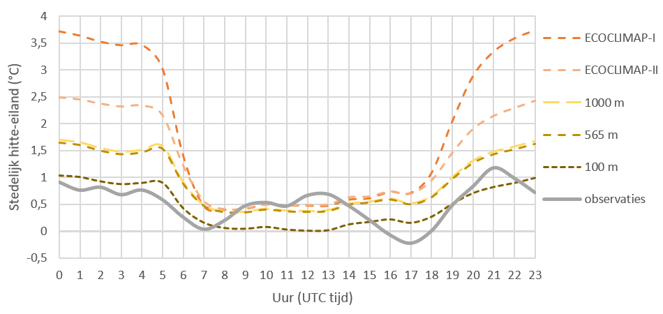 Uit de studie volgde dat het model zeer gevoelig is aan wijzigingen in de bodembedekking, zoals water, groene en verharde oppervlakte. Daarnaast resulteerde de implementatie van bodembedekkingsgegevens met een hogere resolutie in een betere modellering van het stedelijk hitte-eiland. Daarom is het belangrijk om accurate bodembedekkingsdata te gebruiken bij de modellering van het stedelijk hitte-eiland. Bovendien vonden we dat een groter aandeel groene oppervlakte leidt tot een gemiddeld lagere temperatuur en dat een grotere fractie verharde oppervlakte leidt tot gemiddeld hogere temperaturen. De implementatie van nauwkeurigere gebouwhoogtes zorgde in mindere mate voor veranderingen in de resulterende temperaturen die het model produceerde.
Bijkomend werd gevonden dat het belangrijk is om rekening te houden met de grootte van het gebied rondom het meetstation die het stedelijk hitte-eiland beïnvloedt om dit verder te gebruiken in de modellering. Voor de zes meetlocaties in Gent kunnen we besluiten dat de nabije omgeving (tot straal van 100 m) belangrijk is om de geobserveerde temperaturen overdag te begrijpen en dat de lokale omgeving (tot straal van 600 m) belangrijk is om het stedelijk hitte-eiland tijdens de nacht te verklaren.
Uit dit onderzoek volgt dat groene ruimten in de stad belangrijk zijn om steden leefbaar te houden tijdens hittegolven aangezien bodembedekking een grote rol speelt bij de temperatuur die we waarnemen in de stad. Daarnaast zijn we op de goede weg om het stadsklimaat te begrijpen en te voorspellen. Hopelijk zijn we binnenkort in staat om te voorspellen of we nu die extra trui nodig hebben of niet voor een nachtelijk uitje in de binnenstad.
Geïnteresseerd in hoe sterk het weer op de verschillende locaties in Gent momenteel varieert? Neem dan een kijkje op de website: http://mocca.ugent.be.
Bibliografie
AGIV (2016a) “Operationele aanmaak Bodembedekkingsbestanden Vlaanderen 2012”. Report.
AGIV (2016b) “3D GRB; Vectoriële bestanden van het GRB in 3D; Versie 2”. Report.
ALADIN International Team (1997) “The ALADIN project: Mesoscale modelling seen as a basic tool for weather forecasting and atmospheric research”. WMO Bulletin, 46, 317-324.
Arnfield, A. J. (2003) “Two decades of urban climate research: a review of turbulence, exchanges of energy and water, and the urban heat island”. International journal of climatology, 23 (1), 1-26.
Bassett, R., Cai, X., Chapman, L., Heaviside, C., Thornes, J. E., Muller, C. L., Young, D. T., Warren, E. L. (2016) “Observations of urban heat island advection from a high‐density monitoring network”. Quarterly Journal of the Royal Meteorological Society, 142 (699), 2434-2441.
Berckmans, J. (2018) “Modelling land-atmosphere interactions: impact of near future land use and climate change over Western Europe”. (Doctoral dissertation, University of Antwerp).
Berrisford, P., Dee, D., Poli, P., Brugge, R., Fielding, K., Fuentes, M., Kallberg, P., Kobayashi, S., Uppala, S., Simmons, A. J. (2011) “The ERA-Interim archive version 2.0”. Report.
Best, M. J., Grimmond, C. S. B. (2015) “Key conclusions of the first international urban land surface model comparison project”. Bulletin of the American Meteorological Society, 96 (5), 805-819.
Blankenstein, S., Kuttler, W. (2004) “Impact of street geometry on downward longwave radiation and air temperature in an urban environment”. Meteorologische Zeitschrift. 13 (5), 373-379.
Bubnová, R., Hello, G., Bénard, P., Geleyn, J. F. (1995) “Integration of the fully elastic equations cast in the hydrostatic pressure terrain-following coordinate in the framework of the ARPEGE/Aladin NWP system”. Monthly Weather Review. 123 (2), 515-535.
Caluwaerts S., Termonia P., Hamdi, R., Duchêne, F., Berckmans, J., Degrauwe, D., Wauters, G. (2016) “Monitoring the urban climate of the city of Ghent, Belgium”. Urban Climate News. 61, 15-20.
Caluwaerts, S., Hamdi, R., Lauwaet, D., Berckmans, J., Degrauwe, D., De Ridder, K., Duchêne, F., Maiheu, B., Verdonck, M.-L., Wauters, G., Termonia, P. (2018) “Design of MOCCA monitoring network in the city of Ghent based on high-resolution urban modelling”. International Journal of Climatology. under revision.
CNRM (s.d.) “The externalized surface user’s guide V8.0”. user’s guide. Download available at: http://www.umr-cnrm.fr/surfex/spip.php?rubrique10. 17/02/2018.
De Ridder, K., Lauwaet, D., Maiheu, B. (2015) “UrbClim - A fast urban boundary layer climate model”. Urban Climate. 12, 21-48.
Dee, D. P., Uppala, S. M., Simmons, A. J., Berrisford, P., Poli, P., Kobayashi, S., Andrae, U., Balmaseda, M. A., Balsamo, G., Bauer, P., Bechtold, P., Beljaars, A. C. M., van den Berg, L., Bidlot, J., Bormann, N., Delsol, C., Dragani, R., Fuentes, M., Geer, A. J., Haimberger, L., Healy, S.B., Hersbach, H., Hólm, E. V., Isaksen, L., Kallberg, P., Köhler, M., Matricardi, M., McNally, A. P., Monge-Sanz, B. M., Morcrette, J.-J., Park, B.-K., Peubey, C., de Rosney, P., Tavolato, C., Thépaut, J.-N., Vitart, F. (2011). “The ERA‐Interim reanalysis: Configuration and performance of the data assimilation system”. Quarterly Journal of the royal meteorological society. 137 (656), 553-597.
Duerinckx, A., Hamdi, R., Mahfouf, J. F., Termonia, P. (2015) “Study of the Jacobian of an extended Kalman filter for soil analysis in SURFEXv5”. Geoscientific Model Development, 8 (3), 845-863.
Faroux, S., Kaptué Tchuenté, A. T., Roujean, J. L., Masson, V., Martin, E., Moigne, P. L. (2013) “ECOCLIMAP-II/Europe: a twofold database of ecosystems and surface parameters at 1 km resolution based on satellite information for use in land surface, meteorological and climate models”. Geoscientific Model Development. 6 (2), 563-582.
Fischer, E. M., Oleson, K. W., Lawrence, D. M. (2012) “Contrasting urban and rural heat stress responses to climate change”. Geophysical research letters, 39(3).
Gaspar, P., Grégoris, Y., Lefevre, J. M. (1990) “A simple eddy kinetic energy model for simulations of the oceanic vertical mixing: Tests at station Papa and Long‐Term Upper Ocean Study site”. Journal of Geophysical Research: Oceans, 95 (C9), 16179-16193.
Gerard, L., Piriou, J. M., Brožková, R., Geleyn, J. F., Banciu, D. (2009) “Cloud and precipitation parameterization in a meso-gamma-scale operational weather prediction model”. Monthly Weather Review. 137 (11), 3960-3977.
Hamdi, R., Deckmyn, A., Termonia, P., Demarée, G. R., Baguis, P., Vanhuysse, S., Wolff, E. (2009) “Effects of historical urbanization in the Brussels Capital Region on surface air temperature time series: a model study”. Journal of Applied Meteorology and Climatology, 48(10), 2181-2196.
Hamdi, R., Degrauwe, D., Termonia, P. (2012) “Coupling the Town Energy Balance (TEB) scheme to an operational limited-area NWP model: evaluation for a highly urbanized area in Belgium”. Weather and Forecasting. 27 (2), 323-344.
Hamdi, R., Masson, V. (2008) “Inclusion of a drag approach in the Town Energy Balance (TEB) scheme: Offline 1D evaluation in a street canyon”. Journal of Applied Meteorology and Climatology, 47 (10), 2627-2644.
Hamdi, R., Schayes, G. (2008) “Sensitivity study of the urban heat island intensity to urban characteristics”. International Journal of Climatology. 28 (7), 973-982.
Hamdi, R., Vyver, H., Troch, R., Termonia, P. (2014). “Assessment of three dynamical urban climate downscaling methods: Brussels's future urban heat island under an A1B emission scenario”. International Journal of Climatology. 34 (4), 978-999.
Hamdi, R., Giot, O., De Troch, R., Deckmyn, A., Termonia, P. (2015). “Future climate of Brussels and Paris for the 2050s under the A1B scenario”. Urban Climate, 12, 160-182.
Harshan, S. (2015) “Adaptation of an urban land surface model to a tropical suburban area: Offline evaluation, sensitivity analysis, and optimization of TEB/ISBA (SURFEX)”. (Doctoral dissertation, M.S. Texas Tech University).
Hertoghs, R. (2012) “De zeebries in belgië en de interactie ervan met urbanisatie: een modelstudie”. (Master thesis, Ghent University).
Laaidi, K., Zeghnoun, A., Dousset, B., Bretin, P., Vandentorren, S., Giraudet, E., Beaudeau, P. (2012) “The impact of heat islands on mortality in Paris during the August 2003 heat wave”. Environmental health perspectives. 120 (2), 254-259.
Lauwaet, D., De Ridder, K., Saeed, S., Brisson, E., Chatterjee, F., van Lipzig, N. P. M., Maiheu, B., Hooyberghs, H. (2016) “Assessing the current and future urban heat island of Brussels”. Urban Climate. 15, 1-15.
Lauwaet, D., Hooyberghs, H., Maiheu, B., Lefebvre, W., Driesen, G., Van Looy, S., De Ridder, K. (2015) “Detailed Urban Heat Island projections for cities worldwide: dynamical downscaling CMIP5 global climate models”. Climate. 3 (2), 391-415.
Le Moigne, P., Boone, A., Belamari, S., Brun, E., Calvet, J.-C., Decharme, B., Faroux, S., Gibelin, A.-L., Giordani, H., Lafont, S., Lebeaupin, C., Mahfouf, J.-F., Martin, E., Masson, V., Mironov, D., Morin, S., Noilhan, J., Tulet, P., Van Den Hurk, B., Vionnet, V. (2018) “SURFEX scientific documentation”. Note de centre (CNRM/GMME), Météo-France, Toulouse, France.
Lemonsu, A., Grimmond, C. S. B., Masson, V. (2004) “Modeling the surface energy balance of the core of an old Mediterranean city: Marseille”. Journal of Applied Meteorology. 43 (2), 312-327.
Masson, V. (2000) “A physically-based scheme for the urban energy budget in atmospheric models”. Boundary-layer meteorology. 94 (3), 357-397.
Masson, V., Champeaux, J. L., Chauvin, F., Meriguet, C., Lacaze, R. (2003) “A global database of land surface parameters at 1-km resolution in meteorological and climate models”. Journal of climate. 16 (9), 1261-1282.
Masson, V., Grimmond, C. S. B., Oke, T. R. (2002) “Evaluation of the Town Energy Balance (TEB) scheme with direct measurements from dry districts in two cities”. Journal of applied meteorology, 41(10), 1011-1026.
Masson, V., Le Moigne, P., Martin, E., Faroux, S., Alias, A., Alkama, R., Belamari, S., Barbu, A., Boone, A., Bouyssel, F., Brousseau, P., Brun, E., Calvet, J.-C., Carrer, D., Decharme, B., Delire, C., Donier, S., Essaouini, K., Gibelin, A.-L., Giordani, H., Habets, F., Jidane, M., Kerdraon, G., Kourzeneva, E., Lafaysse, M., Lafont, S., Lebeaupin Brossier, C., Lemonsu, A., Mahfouf, J.-F., Marguinaud, P., Mokhtari, M., Morin, S., Pigeon, G., Salgado, R., Seity, Y., Taillefer, F., Tanguy, G., Tulet, P., Vincendon, B., Vionnet, V., Voldoire, A. (2013) “The SURFEXv7.2 land and ocean surface platform for coupled or offline simulation of earth surface variables and fluxes”. Geoscientific Model Development. 6, 929-960.
Mironov, D. V. (2008). “Parameterization of lakes in numerical weather prediction”. Deutscher Wetterdienst, COSMO Technical Report 11.
Mirzaei, P. A., Haghighat, F. (2010) “Approaches to study urban heat island–abilities and limitations”. Building and environment. 45 (10), 2192-2201.
Morris, C. J. G., Simmonds, I., Plummer, N. (2001) “Quantification of the influences of wind and cloud on the nocturnal urban heat island of a large city”. Journal of Applied Meteorology. 40 (2), 169-182.
Ohashi, Y., Genchi, Y., Kondo, H., Kikegawa, Y., Yoshikado, H., Hirano, Y. (2007) “Influence of air-conditioning waste heat on air temperature in Tokyo during summer: numerical experiments using an urban canopy model coupled with a building energy model”. Journal of Applied Meteorology and climatology. 46 (1), 66-81.
Oke, T. R. (1973) “City size and the urban heat island”. Atmospheric Environment (1967). 7 (8), 769-779.
Oke, T. R. (1981) “Canyon geometry and the nocturnal urban heat island: comparison of scale model and field observations”. Journal of climatology. 1 (3), 237-254.
Oke, T. R. (1982) “The energetic basis of the urban heat island”. Quarterly Journal of the Royal Meteorological Society. 108 (455), 1-24.
Oke, T. R. (1987) “Boundary layer climates”. 2nd. Methuen. 289p.
Patz, J. A., Campbell-Lendrum, D., Holloway, T., Foley, J. A. (2005) “Impact of regional climate change on human health”. Nature, 438 (7066), 310-317.
Pielke, R. A., Davey, C. A., Niyogi, D., Fall, S., Steinweg‐Woods, J., Hubbard, K., Lin, X., Cai, M., Lim, Y.-K., Li, H., Nielsen‐Gammon, J., Gallo, K., Hale, R., Mahmood, R., Foster, S., McNider, R. T., Blanken, P. (2007) “Unresolved issues with the assessment of multidecadal global land surface temperature trends”. Journal of Geophysical Research: Atmospheres. 112(D24).
Prein, A. F., Langhans, W., Fosser, G., Ferrone, A., Ban, N., Goergen, K., Keller, M., Tölle, M., Gutjahr, O., Feser, F., Brisson, E., Kollet, S., Schmidli, J., van Lipzig, N. P. M., Leung, R. (2015) “A review on regional convection‐permitting climate modeling: Demonstrations, prospects, and challenges”. Reviews of geophysics, 53 (2), 323-361.
Sailor, D. J., Lu, L. (2004) “A top–down methodology for developing diurnal and seasonal anthropogenic heating profiles for urban areas”. Atmospheric environment. 38 (17), 2737-2748.
Shepherd, J. M. (2005) “A review of current investigations of urban-induced rainfall and recommendations for the future”. Earth Interactions. 9 (12), 1-27.
Steeneveld, G. J., Koopmans, S., Heusinkveld, B. G., Van Hove, L. W. A., Holtslag, A. A. M. (2011) “Quantifying urban heat island effects and human comfort for cities of variable size and urban morphology in the Netherlands.” Journal of Geophysical Research: Atmospheres. 116 (D20).
Termonia, P., Fischer, C., Bazile, E., Bouyssel, F., Brozková, R., Bénard, P., Bochenek, B., Degrauwe, D., Derková, M., El Khatib, R., Hamdi, R., Masek, J., Pottier, P., Pristov, N., Seity, Y., Smolíková, P., Spaniel, O., Tudor, M., Wang, Y., Wittmann, C., Joly, A. (2018). “The ALADIN System and its canonical model configurations AROME CY41T1 and ALARO CY40T1”. Geoscientific Model Development. 11 (1), 257.
United Nations Human Settlements Programme (UN-Habitat) (2010) “State of the World’s Cities 2008/2009”.
U.S. Environmental Protection Agency. (2008) “Reducing urban heat islands: Compendium of strategies”. Draft. https://www.epa.gov/heat-islands/heat-island-compendium.
Van Hove, L. W. A., Jacobs, C. M. J., Heusinkveld, B. G., Elbers, J. A., Van Driel, B. L., Holtslag, A. A. M. (2014) “Temporal and spatial variability of urban heat island and thermal comfort within the Rotterdam agglomeration”. Building and environment. 83, 91-103.
Voogt, J. A. (2000) “Urban heat island”. Encyclopedia of Global Environmental Change. 3, 660-666.
Zhou, W., Huang, G., Cadenasso, M. L. (2011) “Does spatial configuration matter? Understanding the effects of land cover pattern on land surface temperature in urban landscapes”. Landscape and urban planning. 102 (1), 54-63.
Internet sources
Agentschap Informatie Vlaanderen (2016) Bodembedekkingskaart (BBK), 1 m resolutie, opname 2012. http://www.geopunt.be/catalogus/datasetfolder/b15fec52-6f04-4758-bef7-1…. 08/04/2018.
AGIV (s.d.) 3D GRB. https://download.agiv.be/Producten/Detail?id=971&title=3D_GRB. 07/04/2018.
CNRM (2018) How to get the SURFEX code. http://www.umr-cnrm.fr/surfex/spip.php?article387. 11/04/2018.
CNRS (2014) Ecoclimap. https://opensource.umr-cnrm.fr/projects/ecoclimap/files. 25/04/2018.
Department of Physics and Astronomy Ghent University (s.d.) MOCCA project: Ghent University studies urban microclimate in Ghent. www.observatory.ugent.be. 30/04/2017.
ECMWF (s.d.) ERA-Interim. https://www.ecmwf.int/en/forecasts/datasets/archive-datasets/reanalysis…. 11/05/2018.
Meso-NH (2015) Download Meso-NH. http://mesonh.aero.obs-mip.fr/mesonh52/Download. 25/04/2018.
Statbel (2016) Loop van de bevolking per gemeente 2010-2016. https://statbel.fgov.be/nl/themas/bevolking/loop-van-de-bevolking#figur…. 21/04/2018.
USGS (2015) Global 30 Arc-Second Elevation (GTOPO30). https://lta.cr.usgs.gov/GTOPO30. 25/04/2018.
Vlaamse overheid (s.d.) Geopunt-kaart. http://www.geopunt.be/. 11/04/2018.