De ontwikkeling van een nieuwe classificatie-index op basis van open source Sentinel-satellietbeelden.
- GillesGhyselinck
Correcte landgebruikskaarten zijn van belang op veel domeinen. Te denken valt bijvoorbeeld aan overstromingsrisico management, ruimtelijke planning, rampenbestrijding en preventie enz.
In Westerse landen is een overvloed aan data en middelen beschikbaar, wat het produceren van zeer nauwkeurige grootschalige kaarten mogelijk maakt. Ontwikkelingslanden hebben hiervoor echter onvoldoende middelen en zijn dus meestal afhankelijk van open-source satellietbeelden voor het karteren van bijvoorbeeld landgebruik. Deze kartering gebeurt veelal automatisch met speciaal daarvoor ontwikkelde indexen.
De meeste bestaande indexen werden ontwikkeld om te gebruiken met beelden van oudere satellieten, waarvan de beeldresolutie te laag is om kleinere landoppervlaktekenmerken te herkennen. Hierdoor ontstaan fouten in de classificatie en dus de kaarten. Daarom werd op zoek gegaan naar de mogelijkheden om deze kartering uit te voeren op basis van de vrij nieuwe Sentinel-2 beelden. De reden hiervoor is dat deze beelden een betere resolutie bezitten dan de andere open source satellietbeelden en dat de waarnemingen in meerdere spectrale banden gebeuren. Beide eigenschappen zorgen ervoor dat een accuratere classificatie mogelijk is. Momenteel gebeurt veel onderzoek naar de mogelijkheden om deze Sentinel-beelden te gebruiken voor de classificatie van landgebruik op basis van de bestaande indexen of om nieuwe en betere indexen te ontwikkelen die optimaal gebruik maken van de 13 spectrale banden van de Sentinels.
Het hoofddoel van het onderzoek was daarom de ontwikkeling van een nieuwe index voor de classificatie van vegetatie en water. Bijkomend doel was ook om vervolgens een tool te ontwerpen voor ArcGIS die ook aan een minder ervaren GIS-gebruiker toelaat om deze nieuwe index te gebruiken via een volledig automatisch werkende classificatie.
In de studie zijn beelden gebruikt die gemaakt zijn door de nog vrij nieuwe Sentinel-2 satellieten, die de gereflecteerde straling van objecten op het aardoppervlak (spectrale waarde genoemd) registreren in 13 verschillende spectrale banden die elk met een andere golflengte van het elektromagnetisch spectrum samenvallen. Zo worden van hetzelfde oppervlak 13 verschillende beelden geproduceerd. Een mathematische combinatie van deze beelden wordt een index genoemd. Vaak worden hiervoor banden met tegengestelde waarden gebruikt, omdat hierdoor een groter verschil tussen de klassen bekomen wordt. Met goede combinaties van beelden komen verschijnselen aan het licht die met het blote oog niet zichtbaar zijn (bv. verdroging of ziekte van vegetatie, bodemverontreiniging, etc.). Het werken met indexen in plaats van beelden betekent een grote verbetering voor de classificering van onder andere landgebruik.
In dit onderzoek werd nog een stap verder gegaan door gebruik te maken van een nieuwe methode. In plaats van verschillende banden te combineren tot een index, werden drie zorgvuldig gekozen indexen gecombineerd tot een nieuwe index, genoemd de Water Vegetation Composite Multi-Index of kort WVCMI.
De WVCMI is gebaseerd op de combinatie van de Normalized Difference Vegetation Index (NDVI) op het rode spectrum, de Soil Adjusted Vegetation Index (SAVI) op het groene spectrum en de Normalized Difference Water Index (NDWI) op het blauwe spectrum. De ontwikkeling van deze combinatie werd gekoppeld aan de laatste bevindingen uit de literatuur.
Voor de validatie van de resultaten van de nieuwe WVCMI en de tool, werden case studies gekozen verspreid over Vlaanderen, omdat hier voldoende grootschalige informatie vrij beschikbaar is.
Het resultaat van deze case studies toont aan dat de nieuwe WVCMI in combinatie met Sentinel-2 beelden de klassen met een zeer goede nauwkeurigheid kan onderscheiden. Dit werd in het onderzoek aangetoond door enerzijds de classificatie te vergelijken met bestaand grootschalig kaartmateriaal en anderzijds door een vergelijking te maken met de meest gebruikte index op wereldniveau voor Landsat-beelden. Uit deze vergelijking bleek dat tot 35% meer pixels juist geclassificeerd werden met de nieuwe index.
Tenslotte werd op basis van Python een volledig automatisch script voor ArcGIS ontwikkeld, waarbij na het invoeren van de benodigde banden een automatische classificatie gebeurt voor de klassen “Water”, “Vegetatie” en “Andere”. Met behulp van deze tool kunnen ook minder ervaren GIS-gebruikers op een gebruiksvriendelijke wijze landgebruiksclassificatiekaarten produceren.
Hoewel het onderzoek werd uitgevoerd op basis van test cases in Vlaanderen, is het uiteraard de bedoeling dat de index en de tool overal ter wereld kunnen ingezet worden, zowel in ontwikkelde- als in ontwikkelingslanden. Voor deze laatste is dit onderzoek echter nog van groter belang, omdat daar vaak niet de middelen beschikbaar zijn om dure hoge resolutiebeelden aan te kopen.
Hieronder worden enkele afbeeldingen weergegeven ter illustratie met een korte uitleg.
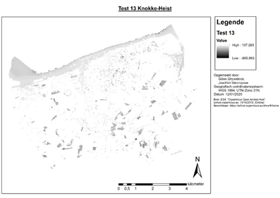
Afbeelding 1 (Test 13 Knokke-Heist): Weergave van een slechte combinatie, waardoor er geen goed onderscheid gemaakt kan worden tussen de benodigde klassen.
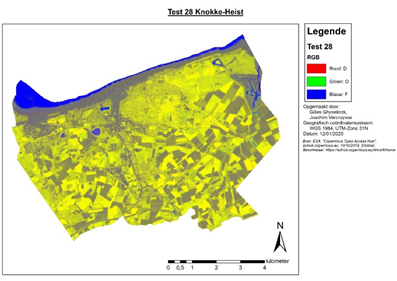
Afbeelding 2 (Test 28 Knokke-Heist): Weergave van een zeer goede combinatie, waardoor gemakkelijk onderscheid gemaakt kan worden tussen de benodigde klassen. Dit is de uiteindelijk gecreëerde index genaamd Water Vegetation Composite Multi-Index of kort WVCMI.
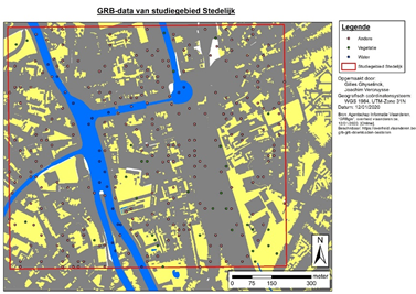
Afbeelding 3 (GRB-data van studiegebied Stedelijk): Weergave van een studiegebied uit het onderzoek op basis van gekende GRB-data.
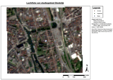
Afbeelding 4 (Luchtfoto van studiegebied Stedelijk): Weergave van een studiegebied uit het onderzoek op basis van een luchtfoto.
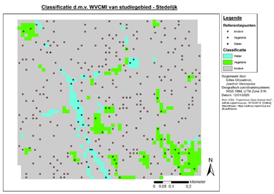
Afbeelding 5 (Classificatie d.m.v. WVCMI van studiegebied – Stedelijk): Resultaat van een studiegebied uit het onderzoek. De kaart werd bekomen door toepassing van de nieuwe gecreëerde tool in combinatie de WVCMI.
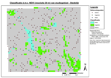
Afbeelding 6 (Classificatie d.m.v. NDVI (resolutie 20 m) van studiegebied – Stedelijk): Resultaat van een studiegebied uit het onderzoek. De kaart werd bekomen door toepassing van de nieuwe gecreëerde tool in combinatie met de NDVI. De NDVI is tot op heden de meeste gebruikte index wereldwijd.
Bibliografie
A. Sánchez-Espinosa, C. S. (2019). Land use and land cover mapping in wetlands one step closer to the ground: Sentinel-2 versus Landsat 8. Journal of Environmental Management , 484-498.
A., G. A., Viña, A., Ciganda, V., Rundquist, D. C., & Arkebauer, T. J. (2005). Remote estimation of canopy chlorophyll content in crops . Geophys. Res. Lett.
Alemu, M. M. (2016). Automated Farm Field Delineation From Satellite Images. Enschede, The Netherlands: University of Twente.
Antrop, M. (2007). Reflecting upon 25 years of landscape ecology. Landscape Ecology, 1441–1443.
Arekhi, M., Goksel, C., Sanli, F. B., & Senel, G. (2019). Comparative Evaluation of the Spectral and Spatial Consistency of Sentinel-2 and Landsat-8 OLI Data for Igneada Longos Forest. MDPI, 13.
Ben-Dor, E., Patkin, K., Banin, A., & Karnieli, A. (2002). Mapping of several soil properties using DAIS-7915 hyperspectral scanner data. A case study over clayey soils in Israel. Int. J. Remote Sens., 1043–1062.
Bontemps, S., Arias, M., Cara, C., Dedieu, G., Guzzonato, E., Hagolle, O., . . . Defourny, P. (2015). Building a Data Set over 12 Globally Distributed Sites to Support the Development of Agriculture Monitoring Applications with Sentinel-2. MDPI, 16062-16090.
Carleer, A. P., Debeir, O., & Wolff, E. (2005). Assessment of Very High Spatial Resolution Satellite Image Segmentations. American Society for Photogrammetry and Remote Sensing, 1285-1294.
Chen, B., Qiu, F., Wu, B., & Du, H. (2015). Image Segmentation Based on Constrained Spectral Variance Difference and Edge Penalty. MDPI, 5980-6004.
Chen, D. Y., Huang, J. F., & Jackson, T. J. (2005). Vegetation water content estimation for corn and soybeans using spectral indices derived from MODIS near- and short-wave infrared bands. Remote Sensing of Environment, 225–236.
Cho, M., & Skidmore, A. (2006). A new technique for extracting the red edge position from hyperspectral data: The linear extrapolation method. Remote Sensing of Environment, 181-193.
Chowdary, V., Vinu Chandran, R., Neeti, N., Bothale, R., Srivastava, Y., Ingle, P., . . . al., e. (2008). Assessment of surface and sub-surface waterlogged areas in irrigation command areas of Bihar state using remote sensing and GIS. Agr. Water Manag., 754-766.
Clevers, J., & et al. (2002). Derivation of the red edge index using the MERIS standard band setting. Int. J. Remote Sens., 3169–3184.
Collins, W. (1978). Remote Sensing of crop type and maturity. Photogrammetric Engineering and Remote Sensing, 43-55.
CRISP. (2001). Spaceborn Remote Sensing. Retrieved from Centre for Remote Imaging, Sensing & Processing: https://crisp.nus.edu.sg/~research/tutorial/spacebrn.htm
Curran, P. (1989). Remote sensing of foliar chemistry. Remote Sensing of Environment, 271-278.
Daughtry, C., Serbin, G., Reeves, J., Doraiswamy, P., & Hunt, E. (2010). Spectral Reflectance of Wheat Residue during Decomposition and Remotely Sensed Estimates of Residue Cover. Remote Sens. , 416–431.
Dawson, T., & Curran, P. (1998). A new technique for interpolating the reflectance red edge position . International Journal of Remote Sensing, 2133-2139.
Delegido, J., Verrelst, J., Alonso, L., & Moreno, J. (2011). Evaluation of Sentinel-2 Red-Edge Bands for Empirical Estimation of Green LAI and Chlorophyll Content. Sensors, 7063–7081.
Deruyter, G. (2018). Cursus 3D Data. Gent: Universiteit Gent.
Drusch, M., Del Bello, U., Carlier, S., Colin, O., Fernandez, V., Gascon, F., . . . Bargellini, P. (2012). Sentinel-2: ESA's Optical High-Resolution Mission for GMES Operational Services. Elsevier, 25-36.
Du, Y., Zhang, Y., Ling, F., Wang, Q., Li, W., & Li, X. (2016). Water Bodies’ Mapping from Sentinel-2 Imagery with Modified Normalized Difference Water Index at 10-m Spatial Resolution Produced by Sharpening the SWIR Band. Remote Sensing, 354.
Du, Z., Li, W., Zhou, D., Tian, L., Ling, F., Wang, H., . . . Sun, B. (2014). Analysis of Landsat-8 OLI imagery for land surface water mapping . Remote Sensing, 672–681.
Environmental Protection Agency. (2005). Wetland Mapping and Classification Methodology, Overall Framework, A Method to Provide Baseline Mapping and Classification for Wetlands in Queensland. Queensland Australia: Queensland Government: Brisbane.
EOS. (2019, mei 12). Sentinel-2. Retrieved from Earth Observing System Listening to the pulse of the planet: https://eos.com/sentinel-2/
ESA. (2019, mei 4). Copernicus - Overview. Retrieved from ESA: https://m.esa.int/Our_Activities/Observing_the_Earth/Copernicus/Overvie…
ESA. (2019, mei 5). Sentinel-2 Missions. Retrieved from ESA: https://earth.esa.int/web/sentinel/missions/sentinel-2
ESA. (2019, mei 5). Sentinel-2 MSI Technical Guide. Retrieved from ESA: https://earth.esa.int/web/sentinel/technical-guides/sentinel-2-msi
ESA. (2019, mei 12). User Guides. Retrieved from ESA: https://sentinel.esa.int/web/sentinel/user-guides
ESA. (2019, mei 18). Wat is remote sensing? Retrieved from ESA eduspace: http://www.esa.int/SPECIALS/Eduspace_NL/SEM7YBE3GXF_0.html
Esfahani, A. G. (2014). DELINEATION OF ARGICULTURAL FIELD BOUNDARIES USING RANDOM SETS. Enschede, The Netherlands: University of Twente.
Eskandari, I., Navid, H., & Rangzan, K. (2016). Evaluating spectral indices for determining conservation and conventional tillage systems in a vetch-wheat rotation. Int. Soil Water Conserv. Res. , 93–98.
Ettehadi, P. &. (2019). Separating Built-Up Areas from Bare Land in Mediterranean Cities Using Sentinel-2A Imagery. Remote Sensing, 345.
Eumetrain. (2019, November 11). Retrieved from http://www.eumetrain.org/data/3/36/navmenu.php?page=3.2.3
Fan, J., Yau, D. K., Elmagarmid, A. K., & Aref, W. G. (2001). Automatic image segmentation by integrating color-edge extraction and seeded region growing. IEEE, 1454-1466.
Fava, F., Colombo, R., Bocchi, S., Meroni, M., Sitzia, M., Fois, N., & Zucca, C. (2009). Identification of hyperspectral vegetation indices for Mediterranean pasture characterization. International Journal of Applied Earth Observation and Geoinformation, 233-243.
Flood, N. (2017). Comparing Sentinel-2A and Landsat 7 and 8 Using Surface Reflectance over Australia. Remote Sens, 9.
Forkuor, G., Serme, I., Dimobe, K., & Tondoh, J. E. (2017). Landsat-8 vs. Sentinel-2: examining the added value of sentinel-2’s red-edge bands to land-use and land-cover mapping in Burkina Faso. ResearchGate, 26.
Frampton, W., Dash, J., Watmough, G., & Milton, E. (2013). Evaluating the capabilities of Sentinel-2 for quantitative estimation of biophysical variables in vegetation. ISPRS J. Photogramm. Remote Sens., 83–92.
Gamon J. A. et al. (1995). Relationships between NDVI, canopy structure, and photosynthesis in 3 Californian vegetation types. Ecol. Appl., 28–41.
Gao, B. C. (1996). NDWI-A normalized difference water index for remote sensing of vegetation liquid water from space. Remote Sensing of Environment, 257–266.
Gao, Y., Waler, J. P., Allahmoradi, M., Monerris, A., Ryu, D., & Jackson, T. J. (2015). Optical sensing of vegetation water content: a synthesis study. IEEE Journal of Selected Topics in Applied Earth Observations and Remote Sensing, 1456–1464.
Ginis, V. (2017, november 8). Hoe licht ons leven dag en nacht beïnvloedt. Retrieved from Wetenschap in en uit Brussel: https://www.wtnschp.be/wetenschap/technologie/hoe-licht-ons-leven-dag-e…
Gitelson, A. A., & Merzlyak, M. N. (1994). Spectral reflectance changes associated with autumn senescence of aesculus Hippocastanum L. and Acer Platanoides L. leaves. Spectral features and relation to chlorophyll estimation. J. Plant Physiol., 286-292.
Gitelson, A., VIÑA, A., Ciganda, V., Rundquist, D., & Arkebauer, T. (2005). Remote estimation of canopy chlorophyll content in crops. Geophysical Research Letters.
Github, & Sentinel-hub. (2019, November 11). Retrieved from Github.com: https://github.com/sentinel-hub/custom-scripts/blob/master/sentinel-2/s…
Glenn, E., Huete, A., Nagler, P., & Nelson, S. (2008). Relationship Between Remotely-sensed Vegetation Indices, Canopy Attributes and Plant Physiological Processes: What Vegetation Indices Can and Cannot Tell Us About the Landscape. Sensors, 2136-2160.
Hansen, P., & Schjoerring, J. (2003). Reflectance measurement of canopy biomass and nitrogen status in wheat crops using normalized difference vegetation indices and partial least squares regression. Remote Sens. Environ., 542–553.
HEASARC. (2013, mei). The Electromagnetic Spectrum. Retrieved from Imagine The Universe!: https://imagine.gsfc.nasa.gov/science/toolbox/emspectrum1.html
Herold, M., Gardner, M., & Roberts, D. (2003). Spectral resolution requirements for mapping urban areas. IEEE Trans. Geosci. Remote Sens. , 1907–1919.
Hill, M. (2013). Vegetation index suites as indicators of vegetation state in grassland and savanna: an analysis with simulated Sentinel 2 data for a North American transect. Remote Sensing of Environment , 94-111.
Horler, D., Dockray, M., & Barber, J. (1983). The red edge of plant leaf reflectance. International Journal Remote Sensing, 273–288.
Horler, D., Dockray, M., Barber, J., & Barringer, A. (1983). Red edge measurements for remotely sensing plant chlorophyll content. Advances in Space Research, 273-277.
Huete, A. (1988). A soil-adjusted vegetation index (SAVI). Remote Sens. Environ. , 295–309.
Indexdatabase. (2019, November 11). indexdatabase. Retrieved from https://www.indexdatabase.de/db/si-single.php?sensor_id=96&rsindex_id=56
Inglada, J., Arias, M., Tardy, B., Hagolle, O., Valero, S., Morin, D., . . . Koetz, B. (2015). Assessment of an Operational System for Crop Type Map Production Using High Temporal and Spatial Resolution Satellite Optical Imagery. MDPI, 12356-12379.
Isa, I. S., Sulaiman, S. N., & Mustapha, M. (2016). The Automated Segmentation Techniques ofT2-Weighted MRI Images Using K-means Clustering and Otsu-Based Thresholding Method. Jurnal Teknologi, 6, nr. 4, 41-48.
J. Delegido, J. V. (2013). A red-edge spectral index for remote sensing estimation of green LAI over agroecosystems. Eur. J. Agronomy, 42–52.
Jackson, T., Chen, D. Y., Cosh, M., Li, F. Q., Anderson, M., Walthall, C., . . . Hunta, E. R. (2004). Vegetation water content mapping using Landsat data derived normalized difference water index for corn and soybeans. Remote Sensing of Environment, 475-482.
Japan Association of Remote Sensing. (2010, maart). Uitgaven. Retrieved from JARS: http://www.jars1974.net/pdf/03_Chapter02.pdf
Jia, K., Wei, X., Gu, X., Yao, Y., Xie, X., & Li, B. (2014). Land cover classification using Landsat 8 Operational Land Imager data in Beijing, China. Geocarto Int. , 941–951.
Kittler, J., & Illingworth, J. (1985). Minimum Error Thresholding. Pattern recognition, Vol 9, nr. 1, 41-47.
Knockaert, C. (2019, augustus 08). Remote sensing. Retrieved from Vlaams Instituut voor de Zee: http://www.vliz.be/wiki/Remote_sensing
Lebourgeois, V., Dupuy, S., Vintrou, E., Ameline, M., Butler, S., & Bégué, A. (2017). A Combined Random Forest and OBIA Classification Scheme for Mapping Smallholder Agriculture at Different Nomenclature Levels Using Multisource Data (Simulated Sentinel-2 Time Series, VHRS and DEM). MDPI, 1-20.
Lefebvre, A., Sannier, C., & Corpetti, T. (2016). Monitoring Urban Areas with Sentinel-2A Data: Application to the Update of the Copernicus High Resolution Layer Imperviousness Degree. Remote Sens, 8.
Lessio, A., Fissore, V., & Borgogno Mondino, E. (2017). Preliminary Tests and Results Concerning Integration of Sentinel-2 and Landsat-8 OLI for Crop Monitoring. MDPI, 16.
Li, W., Chang, Q., Li, F., Yan, L., Huang, Y., Wang, Q., & Luo, L. (2019). Effects of Growth Stage Development on Paddy Rice Leaf Area Index Prediction Models. Remote Sensing, 361.
Li, W., Du, Z., Ling, F., Zhou, D., Wang, H., Gui, Y., . . . Zhang, X. (2013). A comparison of land surface water mapping using the normalized difference water index from TM, ETM plus and ALI. Remote Sensing, 5530–5549.
Li, Z., Xu, D., & Guo, X. (2014). Remote Sensing of Ecosystem Health: Opportunities, Challenges, and Future Perspectives. Sensors, 21117-21139.
Long, J., Shelhamer, E., & Darrell, T. (2015). Fully Convolutional Networks for Semantic Segmentation. CVPR, 3431-3440.
Lu, D., Mausel, P., Batistella, M., & Moran, E. (2005). Land-cover binary change detection methods for use in the moist tropical region of the Amazon: A comparative study. Int. J. Remote Sens., 101–114.
Lunetta, R. S., Shao, Y., Ediriwickrema, J., & Lyon, J. G. (2010). Monitoring agricultural cropping patterns across the Laurentian Great Lakes Basin using MODIS-NDVI data. Elsevier, 81-88.
M. Burke, D. L. (2017). Satellite-based assessment of yield variation and its dterminatnts in small holder African systems. Proc. Natl. Acad. Sci., 2189-2194.
Makkar, H., & Pundir, A. (2014). Image Analysis Using Improved Otsu's Thresholding Method. Researchgate, 2122-2126.
Mandanici, E., & Bitelli, G. (2016). Preliminary Comparison of Sentinel-2 and Landsat 8 Imagery for a Combined Use. MDPI, 10.
Masek, J. G. (2019, mei 16). Landsat 8. Retrieved from Landsat Science: https://landsat.gsfc.nasa.gov/spacecraft/
Masek, J., Lindsay, F., & Goward, S. (2000). Dynamics of urban growth in the Washington DC metropolitan area, 1973–1996, from Landsat observations. International Journal of Remote Sensing, 3473–3486.
McFeeters, S. (2013). Using the Normalized Difference Water Index (NDWI) within a Geographic Information System to Detect Swimming Pools for Mosquito Abatement: A Practical Approach. Remote Sensing, 3544-3561.
McFeeters, S. K. (1996). The use of the Normalized Difference Water Index (NDWI) in the delineation of open water features. Remote Sensing, 1425-1432.
Meyer, L. H., Heurich, M., Beudert, B., Premier, J., & Pflugmacher, D. (2019). Comparison of Landsat-8 and Sentinel-2 Data for Estimation of Leaf Area Index in Temperate Forests. MDPI, 16.
Mróz, M., & Sobieraj-Żłobińska, A. (2004). Comparison of several vegetation indices calculated on the basis of a seasonal SPOT XS time series, and their suitability for land cover and agricultural crop identification. Tech. Sci., 39-66.
Mueller, M., Segl, K., & Kaufmann, H. (2004). Edge- and region-based segmentation technique for the extraction of large, man-made objects in high-resolution satellite imagery. Elsevier, 1619-1628.
Mukesh, S. B. (2016, juli 7). What number of points in field for classify accuracy do I need? Retrieved from ResearchGate: https://www.researchgate.net/profile/Mukesh_Boori
Murray, N., Phinn, S., Clemens, R., Roelfsema, C., & Fuller, R. (2012). Continental scale mapping of tidal flats across East Asia using the Landsat archive. Remote Sensing, 3417–3426.
Mutanga, O., & Skidmore, A. (2007). Red edge shift and biochemical content in grass canopies. ISPRS Journal of Photogrammetry and Remote Sensing, 34-42.
Myint, S., Gober, P., Brazel, A., Grossman-Clarke, S., & Weng, Q. (2011). Per-pixel vs. object-based classification of urban land cover extraction using high spatial resolution imagery. Remote Sens. Environ., 1145–1161.
Natural Resources Canada. (2013, november 18). Image Classification and Analysis. Retrieved from Natural Resources Canada: https://www.nrcan.gc.ca/earth-sciences/geomatics/satellite-imagery-air-…
Natural Resources Canada. (2015a, november 30). Data Integration and Analysis. Retrieved from Natural Resources Canada: https://www.nrcan.gc.ca/earth-sciences/geomatics/satellite-imagery-air-…
Natural Resources Canada. (2015b, november 25). Digital Image Processing. Retrieved from Natural Resources Canada: https://www.nrcan.gc.ca/earth-sciences/geomatics/satellite-imagery-air-…
Natural Resources Canada. (2015c, november 23). Educational Resources - Applications. Retrieved from Natural Resources Canada: https://www.nrcan.gc.ca/earth-sciences/geomatics/satellite-imagery-air-…
Natural Resources Canada. (2015d, november 19). Elements of Visual Interpretation. Retrieved from Natural Resources Canada: https://www.nrcan.gc.ca/earth-sciences/geomatics/satellite-imagery-air-…
Natural Resources Canada. (2015e, november 19). Fundamentals of Remote Sensing - Introduction. Retrieved from Natural Resources Canada: https://www.nrcan.gc.ca/earth-sciences/geomatics/satellite-imagery-air-…
Natural Resources Canada. (2015f, november 20). Image interpretation & analysis. Retrieved from Natural Resources Canada: https://www.nrcan.gc.ca/earth-sciences/geomatics/satellite-imagery-air-…
Natural Resources Canada. (2015g, november 23). Image Transformations. Retrieved from Natural Resources Canada: https://www.nrcan.gc.ca/earth-sciences/geomatics/satellite-imagery-air-…
Natural Resources Canada. (2015h, november 19). Passive vs. Active Sensing. Retrieved from Natural Resources Canada: https://www.nrcan.gc.ca/earth-sciences/geomatics/satellite-imagery-air-…
Natural Resources Canada. (2015i, november 18). Radiation - Target Interactions. Retrieved from Natural Resources Canada: https://www.nrcan.gc.ca/earth-sciences/geomatics/satellite-imagery-air-…
Natural Resources Canada. (2016, 03 02). Interactions with the Atmosphere. Retrieved from Natural Resources Canada: https://www.nrcan.gc.ca/earth-sciences/geomatics/satellite-imagery-air-…
Natural Resources Canada. (2016, augustus 17). Tutorial: Fundamentals of Remote Sensing. Retrieved from Natural Resources Canada: https://www.nrcan.gc.ca/earth-sciences/geomatics/satellite-imagery-air-…
Nedkov, R. (2017). NORMALIZED DIFFERENTIAL GREENNESS INDEX FOR VEGETATION DYNAMICS ASSESSMENT. ResearchGate, 1143-1146.
Pal, M., & Antil, K. (2017). COMPARISON OF LANDSAT 8 AND SENTINEL 2 DATA FOR ACCURATE MAPPING OF BUILT-UP AREA AND BARE SOIL. ResearchGate, 4.
Panigrahy, S., Murthy, T., Patel, J., & Singh, T. (2012). Wetlands of India: Inventory and assessment at 1:50,000 scale using geospatial techniques. Curr. Sci., 852–856.
Piette, T. (2018). Semiautomatische detectie van overstromingsgebieden aan de hand van historische satellietbeelden. Masterproef, 135.
Pittman, K., Hansen, M. C., Becker-Reshef, I., Potapov, P. V., & Justice, C. O. (2010). Estimating Global Cropland Extent with Multi-year MODIS Data. MDPI, 1844-1863.
Radoux, J., Chome, G., Jacques, D., Waldner, F., Bellemans, N., Matton, N., & Defourny, P. (2016). Sentinel-2’s potential for sub-pixel landscape feature detection. Remote Sensing, 488.
Ray, T. (2006). Vegetation in remote sensing FAQs in ER Mapper Application. Perth, Australia: ER Mapper Ltd., 85–97.
Richter, R., & Schläpfer, D. (2007). Atmospheric/Topographic Correction for Satellite Imagery. ATCOR, 1-71.
Ridd, M. (1995). Exploring a V-I-S (vegetation-impervious surface-soil) model for urban ecosystem analysis through remote sensing: comparative anatomy for cities. International Journal of Remote Sensing, 2165–2185.
Roberts, D. A., Green, R. O., & Adams, J. B. (1997). Temporal and spatial patterns in vegetation and atmospheric properties from AVIRIS. Remote Sensing of Environment, 223–240.
Rouse, W., Haas, R. H., Schell, J. A., & Deering, D. W. (1974). Monitoring vegetation systems in the Great Plains with ERTS. In Proceedings of the 3rd ERTS Symposium, (pp. 309-317). Washington DC, USA.
Rydberg, A., & Borgefors, G. (1999). Extracting multispectral edges in satellite images over agricultural fields. IEEE, 786-791.
Salman, N. (2006). Image Segmentation Based on Watershed and Edge Detection Techniques. The International Arab Journal of Information Technology, 104-110.
Satellite Imaging Corporation. (2019, mei 12). Sentinel-2A Satellite Sensor (10m). Retrieved from Satellite Imaging Corporation: https://www.satimagingcorp.com/satellite-sensors/other-satellite-sensor…
Schultz, B., Immitzer, M., Formaggio, A. R., Sanches, I. D., Luiz, A. J., & Atzberger, C. (2015). Self-Guided Segmentation and Classification of Multi-Temporal Landsat 8 Images for Crop Type Mapping in Southeastern Brazil. MDPI, 14482-14508.
Schuster, C., Förster, M., & Kleinschmit, B. (2012). Testing the red edge channel for improving land-use classifications based on high-resolution multi-spectral satellite data. International Journal of Remote Sensing, 5583-5599.
Sentinel-hub. (2019, november 11). NDWI normalized difference water index. Retrieved from Sentinel-hub: https://www.sentinel-hub.com/eoproducts/ndwi-normalized-difference-wate…
Sentinel-hub. (2019, november 11). Sentinel2EOproducts. Retrieved from Sentinel-hub: https://www.sentinel-hub.com/develop/documentation/eo_products/Sentinel…
Shrivakshan, G. T., & Chandrasekar, C. (2012). A comparison of various edge detection techniques used in image processing. IJCSI, 269-276.
Singh, K., Setia, R., Sahoo, S., Prasad, A., & Pateriya, B. (2015). Evaluation of NDWI and MNDWI for assessment of waterlogging by integrating digital elevation model and groundwater level. Geocarto Int., 650–661.
Smith, K. L., Steven, M. D., & Collins, J. J. (2004). Use of hyperspectral derivative ratios in the rededge region to identify plant stress responses to gas leaks. Remote Sensing of Environment, 207-217.
Souza, A. A., Galvao, L. S., & R., S. J. (2010). Relationships between Hyperion-derived vegetation indices, biophysical parameters, and elevation data in a Brazilian savannah environment. Remote Sensing Letters, 55 - 64.
Spaceflight 101. (2019, mei 4). Sentinel Satellites. Retrieved from Spaceflight 101: http://spaceflight101.com/copernicus/sentinel-satellites/
Sykas, D. (2019, November 11). Spectral Indices with multispectral satellite data. Retrieved from Geo University: https://www.geo.university/pages/spectral-indices-with-multispectral-sa…
T. Zhang, J. S. (2017). Band Selection in Sentinel-2 Satellite for Agriculture Applications. International Conference on Automation and Computing (pp. 1-6). Hddersfield: IEEE.
Tucker, C. (1980). Remote sensing of leaf water content in near infrared. Remote Sensing of Environment, 23-32.
Turker, M., & Kok, E. H. (2013). Field-based sub-boundary extraction from remote sensing imagery using perceptual grouping. Elsevier, 106-121.
USGS. (2019, mei 1). Landsat 8. Retrieved from USGS science for a changing world: https://www.usgs.gov/land-resources/nli/landsat/landsat-8?qt-science_su…
USGS. (2019, mei 1). Landsat Missions. Retrieved from USGS science for a changing world: https://www.usgs.gov/land-resources/nli/landsat/landsat-satellite-missi…
Vala, H. J., & Baxi, A. (2013). A Review on Otsu Image Segmentation Algorithm. International Journal of Advanced Research in Computer Engineering & Technology, 2, nr. 2, 397-389.
Van der Werff, H., & Van der Meer, F. (2015). Sentinel-2 for Mapping Iron Absorption Feature Parameters. Remote Sens, 12635-12653.
Van Deventer, A., Ward, A., Gowda, P., & Lyon, J. (1997). Using Thematic Mapper Data to Identify Contrasting Soil Plains and Tillage Practices. Photogramm. Eng. Remote Sens., 87–93.
Vapnik, V. (1998). Statistical Learning Theory. John Wiley and Sons.
Vigneshwaran, S., & Kumar, S. (2018). Extraction of built-up area using high resolution sentinel-2a and google satellite imagery. ISPRS - international archives of the photogrammetry, remote sensing and spatial information sciences.
Viña, A., Gitelson, A. A., Nguy-Robertson, A. L., & Peng, Y. (2011). Comparison of different vegetation indices for the remote assessment of green leaf area index of crops. Remote Sens. Environ., 3468–3478.
Vlaams Instituut voor de Zee. (2018, november 10). Remote Sensing. Retrieved from Vlaams Instituut voor de Zee, Platform voor Marien Onderzoek: http://www.vliz.be/wiki/Remote_sensing
Vlaamse Overheid - Departement Omgeving - Afdeling Vlaams Planbureau voor Omgeving. (2013, juli 1). Landgebruik - Vlaanderen - 2013. Retrieved from Geopunt.be: http://www.geopunt.be/catalogus/datasetfolder/321bfa63-9b04-479f-8faf-4…
Wardlow, B. D., Egbert, S. L., & Kastens, J. H. (2007). Analysis of time-series MODIS 250 m vegetation index data for crop classification in the U.S. Central Great Plains. Elsevier, 290-310.
Watkins, B., & van Niekerk, A. (2019). A comparison of object-based image analysis approaches for field boundary delineation using multi-temporal Sentinel-2 imagery. Elsevier, 294-302.
Wilson, E., & Sader, S. (2002). Detection of forest harvest type using multiple dates of Landsat TM imagery. Remote Sensing of Environment, 385–396.
Wu, C., & Murray, A. (2003). Estimating impervious surface distribution by spectral mixture analysis. Remote Sensing of Environment, 493–505.
Wuest, B., & Zhang, Y. (2009). Region based segmentation of QuickBird multispectral imagery through band ratios and fuzzy comparison. Elsevier, 55-64.
Xie, Q.-y., Dash, J., Huang, W., Peng, D., Qin, Q., Mortimer, H., . . . Ye, H. (2018). Vegetation Indices Combining the Red and Red-Edge Spectral Information for Leaf Area Index Retrieval. IEEE Journal of Selected Topics in Applied Earth Observations and Remote Sensing.
Xu, H. (2006). Modification of normalised difference water index (NDWI) to enhance open water features in remotely sensed imagery. Remote Sensing, 3025-3033.
Xu, H. (2008). A New Index For Delineating Built Up Land Features In Satellite Imagery. Remote Sensing, 4269-4276.
Xu, H., Huang, S., & Zhang, T. (2013). Built-up land mapping capabilities of the ASTER and Landsat ETM plus sensors in coastal areas of southeastern China. Advances in Space Research, 1437–1449.
Yang, Y., Liu, Y., Zhou, M., Zhang, S., Zhan, W., Sun, C., & Duan, Y. (2015). Landsat8 OLI image based terrestrial water extraction from heterogeneous backgrounds using a reflectance homogenization approach. Remote Sensing of Environment. Elsevier, 14-32.
Yantao, X., Nguyen, X. T., & Cheng, L. (2019). Preliminary comparative assessment of various spectral indices for built-up land derived from Landsat-8 OLI and Sentinel-2A MSI imageries. European Journal of Remote Sensing, 240-252.
Yilmaz, M. T., Hunt, E. R., & Jackson, T. J. (2008). Remote sensing of vegetation water content from equivalent water thickness using satellite imagery. Remote Sensing of Environment, 2514–2522.
Zha, Y., Gao, J., & Ni, S. (2003). Use of normalized difference built-up index in automatically mapping urban areas from TM imagery. Int. J. Remote Sens. , 583–594.
Zhang, H., Roy, D., Yan, L., Li, Z., Huang, H., Vermote, E., . . . Roger, J. (2018). Characterization of Sentinel-2A and Landsat-8 top of atmosphere, surface, and nadir BRDF adjusted reflectance and NDVI differences. Remote Sens, 482-494.
Zhang, T., Su, J., Liu, C., Chen, W.-H., Liu, H., & Liu, G. (2017). Band Selection in Sentinel-2 Satellite for Agriculture Applications. ResearchGate, 1-7.
Zhang, Z., Liu, M., Liu, X., & Zhou, G. (2018). A New Vegetation Index Based on Multitemporal Sentinel-2 Images for Discriminating Heavy Metal Stress Levels in Rice. MDPI, 1-15.
Zheng, Q., Huang, W., Cui, X., Shi, Y., & Liu, L. (2018). New Spectral Index for Detecting Wheat Yellow Rust Using Sentinel-2 Multispectral Imagery. MDPI, 19.