DE EFFICIËNTE WEG NAAR KLIMAATADAPTIEVE STEDEN
Het klimaat staat niet stil. De wereldwijde opwarming nadert snel de grens van 1,5 °C boven het pre-industriële niveau, de limiet die beleidsmakers in het Klimaatakkoord van Parijs hebben vastgelegd. Nieuwsberichten tonen reeds lang de impact van deze nieuwe realiteit. Dit was ook het geval in 2024, van hevige regenval in Oost-Europa tot extreme hittegolven in Zuid-Europa. Aanpassingen zijn onvermijdelijk, maar de vragen blijven: hoe, waar en wanneer? Hiervoor is in eerste instantie klimaatdata nodig, ook voor onze steden. Maar hier wringt het schoentje: de resolutie van globale modellen schiet tekort om ons ook inzichten te geven over de temperatuurverschillen binnen een stad.
Traditionele stedelijke klimaatmodellen daarentegen leveren deze details wel, maar ze zijn traag en kosten veel energie. Het simuleren van klimaatdata draagt hierdoor ironisch genoeg een beetje bij aan het klimaatprobleem. Reden te meer voor Jonas Blancke om in zijn masterproef een sneller en energiezuiniger stedelijk klimaatmodel te ontwikkelen dat gebruik maakt van bestaande data en artificiële intelligentie.
STEDEN ZIJN HOTSPOTS
Waarom focussen op steden? Niet alleen huisvesten zij het grootste deel van de wereldbevolking, maar ook groeien stedelijke gebieden voortdurend. Daarnaast speelt het stedelijk hitte-eilandeffect een belangrijke rol. Dit fenomeen doet zich voor doordat materialen zoals asfalt en beton overdag grote hoeveelheden warmte absorberen. 's Nachts komt deze warmte terug langzaam vrij. Hierdoor kunnen de temperaturen in steden tot wel 10 °C hoger oplopen dan in het omliggende platteland. Deze extra hitte komt bovenop de wereldwijde klimaatopwarming. Tijdens hittegolven worden de gevolgen in steden dan ook schrijnend zichtbaar, met een toename van hitte-gerelateerde sterfgevallen, vooral onder kwetsbare groepen zoals ouderen en kinderen.
GEDULD IS NIET ALTIJD EEN SCHONE ZAAK
De traditionele methode om temperatuur te berekenen voor een klimaatscenario steunt op complexe fysische vergelijkingen die niet eenvoudig door een gewone computer kunnen worden berekend. Daarom worden ze uitgevoerd op grote krachtige computers, maar zelfs dan kost het veel tijd, vooral voor grote gebieden en lange periodes. Zo lopen huidige modellen dan ook soms achter de feiten aan. Het kan bijvoorbeeld een jaar duren om een gedetailleerde berekening te maken voor een zomer. Bovendien is het energieverbruik van deze simulaties enorm.
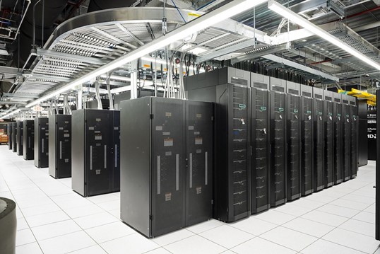
Een supercomputer wordt ingezet voor het uitvoeren van traditionele modelsimulaties.
Dit probleem kan worden opgelost door de complexe fysica met machine learning te vervangen door statistische relaties die veel minder rekenkracht vergen. Het gebruikte algoritme leert de verbanden tussen de temperatuur enerzijds en ruimtelijke (zoals gebouwhoogte) en temporele (zoals windsnelheid) variabelen anderzijds. Dit gebeurt via een reeks beslissingen die splitsingen maken op basis van de waarden van deze variabelen. Het resultaat van deze zogenaamde beslissingsbomen is dan de voorspelde temperatuur voor een specifiek punt in tijd en ruimte. Het grote voordeel van dit model is dat het, zodra het getraind is, simulaties meer dan een miljoen keer sneller kan uitvoeren dan traditionele modellen. Dit kan bovendien op een gewone laptop.
VAN EEN ENKELE STAD TOT VOLLEDIG EUROPA
Is het gebruik van machine learning nieuw in stedelijke klimaatstudies? Neen, maar het verschil zit hem in de toepasbaarheid van het model. Voorgaande modellen trainden hun model met temperatuurdata van één stad, afkomstig van temperatuursimulaties of observaties. Hierdoor zullen deze echter minder accuraat zijn wanneer je het zou willen gebruiken voor een totaal andere stad.
Het nieuw voorgestelde model daarentegen steunt op een gigantische openbare dataset, afkomstig van temperatuursimulaties uit een traditioneel klimaatmodel. Concreet werd hiervoor het UrbClim-model gebruikt, dat werd ontwikkeld door het Vlaams Instituut voor Technologisch Onderzoek (VITO). Door het model te trainen op verschillende steden binnen Europa is het generiek toepasbaar over alle grote steden in Europa, zelfs in regio’s waarvoor momenteel nauwelijks temperatuurdata beschikbaar is.
En wat blijkt? Dit machine learning model weet de temperatuurpatronen en variaties uit UrbClim verrassend goed na te bootsen. Voor temperatuurvoorspellingen op hectare-niveau is het gemiddelde verschil tussen beide modellen minder dan 1 °C. Een interessant resultaat is dat data van slechts enkele steden al voldoende is om een model te trainen dat betrouwbare voorspellingen kan maken voor andere steden. Het is dus zelfs niet eens noodzakelijk om te steunen op een hele grote dataset dat afkomstig is van een duur traditioneel model. Het is echter wel belangrijk om aandacht te hebben voor de representativiteit van de geselecteerde steden. Zo zal een model getraind op steden uit Zuid-Europa minder goed presteren voor steden met een totaal ander klimaat, zoals bijvoorbeeld Reykjavik in Ijsland.
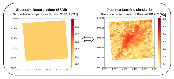
Vergelijking tussen data van een globaal klimaatproduct (links) en het machine learning model (rechts), dat nauw aansluit bij UrbClim.
STADSPLANNING VOOR MORGEN
Op basis van de verkregen resultaten kunnen we zelfs nog een stap verder dromen. We kunnen het model zo aanpassen dat het algemene toekomstige klimaatscenario’s specifiek voor steden kan simuleren. Deze informatie vormt een waardevol startpunt voor het duurzaam inrichten van steden, afgestemd op de specifieke behoeften van elke wijk. Door daarbij extra oog te hebben voor de meest kwetsbare groepen, kunnen we stedelijke omgevingen creëren die niet alleen klimaatbestendig zijn, maar ook sociaal rechtvaardig en leefbaar voor iedereen.
Bibliografie
Acero, J. A., Arrizabalaga, J., Kupski, S., and Katzschner, L. (2013). Urban heat island in a coastal urban area in northern Spain. Theoretical and applied climatology, 113:137–154.
Akbari, H. (2009). Cooling our communities. A guidebook on tree planting and light-colored surfacing. Al-Obaidi, I., Rayburg, S., Półrolniczak, M., and Neave, M. (2021). Assessing the impact of wind conditions on urban heat islands in large Australian cities. Journal of Ecological Engineering, 22(11):1–15.
Allen, L., Lindberg, F., and Grimmond, C. (2011). Global to city scale urban anthropogenic heat flux: model and variability. International Journal of Climatology, 31(13):1990–2005.
Anaga, D., Kerchove, R. V. D., Daems, D., Keersmaecker, W. D., Brockmann, C., Kirches, G., Wevers, J., Cartus, O., Santoro, M., Fritz, S., Lesiv, M., Herold, M., Tsendbazar, N., Xu, P., Ramoino, F., and Arino, O. (2022). ESA WorldCover 10 m 2021 v200. https: //doi.org/10.5281/zenodo.7254221. Accessed on 15/12/2023. Ao, X., Wang, L., Zhi, X., Gu, W., Yang, H., and Li, D. (2019). Observed synergies between urban heat islands and heat waves and their controlling factors in Shanghai, China. Journal of Applied Meteorology and Climatology, 58(9):1955–1972.
Atkinson, B. (2003). Numerical modelling of urban heat-island intensity. Boundary-Layer Meteorology, 109:285–310.
Atwater, M. A. (1977). Urbanization and pollutant effects on the thermal structure in four climatic regimes. Journal of Applied Meteorology and Climatology, 16(9):888–895.
Bader, D. A., Blake, R., Grimm, A., Hamdi, R., Kim, Y., Horton, R., Rosenzweig, C., Alverson, K., Gaffin, S., and Crane, S. (2018). Urban climate science. Climate change and cities: Second assessment report of the urban climate change research network, pages 27–60.
Baklanov, A. (2002). The mixing height in urban areas–a review. Mixing heights and inversions in urban areas, COST Action, 715:9–28. Balsamo, G., Beljaars, A., Scipal, K., Viterbo, P., van den Hurk, B., Hirschi, M., and Betts, A. K. (2009). A revised hydrology for the ECMWF model: Verification from field site to terrestrial water storage and impact in the Integrated Forecast System. Journal of hydrometeorology, 10(3):623–643.
Barlow, J. (2014). Progress in observing and modelling the urban boundary layer, Urban Clim., 10, 216–240.
Barriopedro, D., García-Herrera, R., Ordóñez, C., Miralles, D., and Salcedo-Sanz, S. (2023). Heat waves: Physical understanding and scientific challenges. Reviews of Geophysics, 61(2):e2022RG000780.
Barry, R. and Chambers, R. E. (1966). A preliminary map of summer albedo over England and Wales. Quarterly Journal of the Royal Meteorological Society, 92(394):543–548.
Battles, A. C. and Kolbe, J. J. (2019). Miami heat: urban heat islands influence the thermal suitability of habitats for ectotherms. Global change biology, 25(2):562–576.
Benali, A., Carvalho, A., Nunes, J., Carvalhais, N., and Santos, A. (2012). Estimating air surface temperature in Portugal using MODIS LST data. Remote Sensing of Environment, 124:108–121.
Bernard, J., Musy, M., Calmet, I., Bocher, E., and Kéravec, P. (2017). Urban heat island temporal and spatial variations: Empirical modeling from geographical and meteorological data. Building and Environment, 125:423–438.
Berry, K. L. (2023). But we build buildings: Urban boundary layer. In Conceptual Boundary Layer Meteorology, pages 199–216. Elsevier.
Bishop, S. (2008). pytz - World Timezone Definitions for Python. https://pythonhosted.org/pytz/: :text=pytz Bossard, M., Feranec, J., Otahel, J., et al. (2000). CORINE land cover technical guide: Addendum 2000, volume 40. European Environment Agency Copenhagen.
Boulesteix, A.-L., Janitza, S., Kruppa, J., and König, I. R. (2012). Overview of random forest methodology and practical guidance with emphasis on computational biology and bioinformatics. Wiley Interdisciplinary Reviews: Data Mining and Knowledge Discovery, 2(6):493–507.
Breiman, L. (2001). Random forests. Machine learning, 45:5–32.
Briegel, F., Makansi, O., Brox, T., Matzarakis, A., and Christen, A. (2023). Modelling long-term thermal comfort conditions in urban environments using a deep convolutional encoder-decoder as a computational shortcut. Urban Climate, 47:101359.
Bruse, M. and Fleer, H. (1998). Simulating surface–plant–air interactions inside urban environments with a three dimensional numerical model. Environmental modelling & software, 13(3-4):373–384.
Caluwaerts, S., Hamdi, R., Top, S., Lauwaet, D., Berckmans, J., Degrauwe, D., Dejonghe, H., De Ridder, K., De Troch, R., Duchêne, F., et al. (2020). The urban climate of Ghent, Belgium: A case study combining a high-accuracy monitoring network with numerical simulations. Urban Climate, 31:100565.
Caluwaerts, S., Top, S., Vergauwen, T., Wauters, G., De Ridder, K., Hamdi, R., Mesuere, B., Van Schaeybroeck, B., Wouters, H., and Termonia, P. (2021). Engaging schools to explore meteorological observational gaps. Bulletin of the American Meteorological Society, 102(6):E1126–E1132.
Cangelosi, R. and Goriely, A. (2007). Component retention in principal component analysis with application to cDNA microarray data. Biology direct, 2:1–21. Chen, F., Liu, Y., Liu, Q., and Qin, F. (2015). A statistical method based on remote sensing for the estimation of air temperature in China. International Journal of Climatology, 35(8):2131–2143.
Chen, H., Janizek, J. D., Lundberg, S., and Lee, S.-I. (2020). True to the model or true to the data? arXiv preprint arXiv:2006.16234.
Ching, J., Clarke, J., and Godowitch, J. (1983). Modulation of heat flux by different scales of advection in an urban environment. Boundary-Layer Meteorology, 25:171–191.
Chow, W. T. and Roth, M. (2006). Temporal dynamics of the urban heat island of Singapore. International Journal of Climatology: A Journal of the Royal Meteorological Society, 26(15):2243–2260.
Christen, A. and Vogt, R. (2004). Energy and radiation balance of a central European city. International Journal of Climatology: A Journal of the Royal Meteorological Society, 24(11):1395–1421.
Constantinescu, D., Cheval, S., Caraca¸s, G., and Dumitrescu, A. (2016). Effective monitoring and warning of Urban Heat Island effect on the indoor thermal risk in Bucharest (Romania). Energy and Buildings, 127:452–468.
Copernicus Climate Change Service (C3S) (2023a). ERA5 hourly data on pressure levels from 1940 to present. Copernicus Climate Change Service (C3S) Climate Data Store (CDS), DOI: 10.24381/cds.bd0915c6. Accessed on 15/12/2023. Copernicus Climate Change Service (C3S) (2023b). ERA5 hourly data on single levels from 1940 to present.
Copernicus Climate Change Service (C3S) Climate Data Store (CDS), DOI: 10.24381/cds.adbb2d47. Accessed on 15/12.2023. Cosgrove, A. and Berkelhammer, M. (2018). Downwind footprint of an urban heat island on air and lake temperatures. npj Climate and Atmospheric Science, 1 (1), 46.
Crutzen, P. J. (2004). New directions: the growing urban heat and pollution" island" effect-impact on chemistry and climate. Atmospheric environment, 38(21):3539–3540. Danielson, J. J. and Gesch, D. B. (2011). Global multi-resolution terrain elevation data 2010 (GMTED2010). Technical report, US Geological Survey.
De Pauw, K., Depauw, L., Calders, K., Caluwaerts, S., Cousins, S. A., De Lombaerde, E., Diekmann, M., Frey, D., Lenoir, J., Meeussen, C., et al. (2023). Urban forest microclimates across temperate Europe are shaped by deep edge effects and forest structure. Agricultural and Forest Meteorology, 341:109632. De Ridder, K., Lauwaet, D., and Maiheu, B. (2015). UrbClim–A fast urban boundary layer climate model. Urban Climate, 12:21–48.
Demuzere, M., De Ridder, K., and Van Lipzig, N. (2008). Modeling the energy balance in Marseille: Sensitivity to roughness length parameterizations and thermal admittance. Journal of Geophysical Research: Atmospheres, 113(D16).
Demuzere, M., Kittner, J., Martilli, A., et al. (2022). A global map of local climate zones to support earth system modelling and urban-scale environmental science. Earth Syst Sci Data. Didan, K. (2021). MODIS/Terra Vegetation Indices 16-Day L3 Global 250m SIN Grid V061 [Data set]. NASA EOSDIS Land Processes Distributed Active Archive Center.https:// doi.org/10.5067/MODIS/MOD13Q1.061. Accesed on 30/10/2023.
Dierckx, W., Sterckx, S., Benhadj, I., Livens, S., Duhoux, G., Van Achteren, T., Francois, M., Mellab, K., and Saint, G. (2014). PROBA-V mission for global vegetation monitoring: standard products and image quality. International Journal of Remote Sensing, 35(7):2589–2614.
Dijkstra, L., Poelman, H., and Veneri, P. (2019). The eu-oecd definition of a functional urban area. 2019. URL: https://www. oecd. org/cfe/regional-policy/THE% 20EU-OECD, 20.
Doblas-Reyes, F., Sörensson, A., Almazroui, M., Dosio, A., Gutowski, W., Haarsma, R., Hamdi, R., Hewitson, B., Kwon, W.-T., Lamptey, B., Maraun, D., Stephenson, T., Takayabu, I., Terray, L., Turner, A., and Zuo, Z. (2021). FAQ 10.2 Figure 1. In Masson-Delmotte, V., Zhai, P., Pirani, A., Connors, S., Péan, C., Berger, S., Caud, N., Chen, Y., Goldfarb, L., Gomis, M., Huang, M., Leitzell, K., Lonnoy, E., Matthews, J., Maycock, T., Waterfield, T., Yelekçi, O., Yu, R., and Zhou, B., editors, Climate Change 2021: The Physical Science Basis. Contribution of Working Group I to the Sixth Assessment Report of the Intergovernmental Panel on Climate Change, chapter 10, pages 1363–1512. Cambridge University Press, Cambridge, United Kingdom and New York, NY, USA.
Dos Santos, R. S. (2020). Estimating spatio-temporal air temperature in London (UK) using machine learning and earth observation satellite data. International Journal of Applied Earth Observation and Geoinformation, 88:102066.
Du, H., Zhan, W., Liu, Z., Li, J., Li, L., Lai, J., Miao, S., Huang, F., Wang, C., Wang, C., et al. (2021). Simultaneous investigation of surface and canopy urban heat islands over global cities. ISPRS Journal of Photogrammetry and Remote Sensing, 181:67–83. EEA (2012). European Environment Agency, © European Union. Copernicus Land Monitoring Service, CORINE Land Cover 2012 (vector/raster 100 m), Europe, 6-yearly. https://doi.org/10.2909/a84ae124-c5c5-4577-8e10-511bfe55cc0d. Accessed on 18/01/2024. EEA (2015). European Environment Agency, © European Union. Copernicus Land Monitoring Service, Imperviousness Density 2015 (raster 20 m and 100 m), Europe, 3-yearly. https://doi.org/10.2909/d6152a22-cc3f-4353-8989-14528c0a713d. Accessed on 08/12/2023. European Commission (2018). Developments and Forecasts on Continuing Urbanisation. Retrieved November 24, 2023. Eurostat (2013). Countries 2013 – CNTR_RG_01M_2013_3035. [Dataset] http://ec.europa.eu/eurostat/web/gisco/geodata/referencedata/ administrative-units-statistical-units/countries. Accessed on 26/02/2018.
Fenner, D., Holtmann, A., Meier, F., Langer, I., and Scherer, D. (2019). Contrasting changes of urban heat island intensity during hot weather episodes. Environmental Research Letters, 14(12):124013.
Ferguson, G. and Woodbury, A. D. (2007). Urban heat island in the subsurface. Geophysical research letters, 34(23).
Flanner, M. G. (2009). Integrating anthropogenic heat flux with global climate models. Geophysical Research Letters, 36(2). Florczyk, A. J., Corbane, C., Schiavina, M., Pesaresi, M., Maffenini, L., Melchiorri, M., Politis, P., Sabo, F., Freire, S., Ehrlich, D., Kemper, T., Tommasi, P., Airaghi, D., and Zanchetta, L. (2019a). GHS Urban Centre Database 2015, multitemporal and multidimensional attributes, R2019A. European Commission, Joint Research Centre (JRC) [Dataset]. PID: http://data.europa.eu/89h/53473144-b88c-44bc-b4a3-4583ed1f547e. Accessed on 20/09/2023.
Florczyk, A. J., Melchiorri, M., Corbane, C., Schiavina, M., Maffenini, M., Pesaresi, M., Politis, P., Sabo, S., Freire, S., Ehrlich, D., Kemper, T., Tommasi, P., Airaghi, D., and Zanchetta, L. (2019b). Description of the GHS Urban Centre Database 2015, Public Release 2019, Version 1.0.
Fortuniak, K., Offerle, B., and Grimmond, C. (2005). Application of a slab surface energy balance model to determine surface parameters for urban areas. Lund Electronic Reports in Physical Geography, 5:90–91. Forzieri, G., Cescatti, A., e Silva, F. B., and Feyen, L. (2017). Increasing risk over time of weather-related hazards to the European population: a data-driven prognostic study. The Lancet Planetary Health, 1(5):e200–e208.
Founda, D. and Santamouris, M. (2017). Synergies between Urban Heat Island and Heat Waves in Athens (Greece), during an extremely hot summer (2012). Scientific reports, 7(1):10973.
García-Díez, M., Lauwaet, D., Hooyberghs, H., Ballester, J., De Ridder, K., and Rodó, X. (2016). Advantages of using a fast urban boundary layer model as compared to a full mesoscale model to simulate the urban heat island of Barcelona. Geoscientific Model Development, 9(12):4439–4450.
Gardes, T., Schoetter, R., Hidalgo, J., Long, N., Marquès, E., and Masson, V. (2020). Statistical prediction of the nocturnal urban heat island intensity based on urban morphology and geographical factors-An investigation based on numerical model results for a large ensemble of French cities. Science of The Total Environment, 737:139253.
Genuer, R., Poggi, J.-M., Tuleau-Malot, C., and Villa-Vialaneix, N. (2017). Random forests for big data. Big Data Research, 9:28–46. Gillies, S. (2019). rasterio Documentation. MapBox, July, 23.
Gobakis, K., Kolokotsa, D., Synnefa, A., Saliari, M., Giannopoulou, K., and Santamouris, M. (2011). Development of a model for urban heat island prediction using neural network techniques. Sustainable Cities and Society, 1(2):104–115.
Good, E. J. (2016). An in situ-based analysis of the relationship between land surface “skin” and screen-level air temperatures. Journal of Geophysical Research: Atmospheres, 121(15):8801–8819.
Gorelick, N., Hancher, M., Dixon, M., Ilyushchenko, S., Thau, D., and Moore, R. (2017). Google Earth Engine: Planetary-scale geospatial analysis for everyone. Remote Sensing of Environment.
Gregorutti, B., Michel, B., and Saint-Pierre, P. (2017). Correlation and variable importance in random forests. Statistics and Computing, 27:659–678.
Grimmond, C. S. B., Blackett, M., Best, M. J., Baik, J.-J., Belcher, S., Beringer, J., Bohnenstengel, S., Calmet, I., Chen, F., Coutts, A., et al. (2011). Initial results from Phase 2 of the international urban energy balance model comparison. International Journal of Climatology, 31(2):244–272.
Grimmond, C. S. B., Blackett, M., Best, M. J., Barlow, J., Baik, J., Belcher, S., Bohnenstengel, S., Calmet, I., Chen, F., Dandou, A., et al. (2010). The international urban energy balance models comparison project: first results from phase 1. Journal of applied meteorology and climatology, 49(6):1268–1292.
Gunawardena, K. R., Wells, M. J., and Kershaw, T. (2017). Utilising green and bluespace to mitigate urban heat island intensity. Science of the Total Environment, 584:1040–1055.
Guo, J., Li, Y., Cohen, J. B., Li, J., Chen, D., Xu, H., Liu, L., Yin, J., Hu, K., and Zhai, P. (2019). Shift in the temporal trend of boundary layer height in China using long-term (1979–2016) radiosonde data. Geophysical Research Letters, 46(11):6080–6089.
Guo, J., Miao, Y., Zhang, Y., Liu, H., Li, Z., Zhang, W., He, J., Lou, M., Yan, Y., Bian, L., et al. (2016). The climatology of planetary boundary layer height in China derived from radiosonde and reanalysis data. Atmospheric Chemistry and Physics, 16(20):13309–13319.
Hamada, S. and Ohta, T. (2010). Seasonal variations in the cooling effect of urban green areas on surrounding urban areas. Urban forestry & urban greening, 9(1):15–24.
Hamdi, R., Kusaka, H., Doan, Q.-V., Cai, P., He, H., Luo, G., Kuang, W., Caluwaerts, S., Duchêne, F., Van Schaeybroek, B., et al. (2020). The state-of-the-art of urban climate change modeling and observations. Earth Systems and Environment, 4:631–646.
Hamdi, R., Van de Vyver, H., De Troch, R., and Termonia, P. (2014). Assessment of three dynamical urban climate downscaling methods: Brussels’s future urban heat island under an A1B emission scenario. International Journal of Climatology, 34(4):978–999.
Harris, C. R., Millman, K. J., van der Walt, S. J., Gommers, R., Virtanen, P., Cournapeau, D., Wieser, E., Taylor, J., Berg, S., Smith, N. J., Kern, R., Picus, M., Hoyer, S., van Kerkwijk, M. H., Brett, M., Haldane, A., Fernández del Río, J., Wiebe, M., Peterson, P., Gérard-Marchant, P., Sheppard, K., Reddy, T., Weckesser, W., Abbasi, H., Gohlke, C., and Oliphant, T. E. (2020). Array programming with NumPy. Nature, 585:357–362.
Hartigan, J. A. and Wong, M. A. (1979). Algorithm AS 136: A k-means clustering algorithm. Journal of the Royal Statistical Society. Series C (applied statistics), 28(1):100–108. Heaviside, C., Cai, X.-M., and Vardoulakis, S. (2015). The effects of horizontal advection on the urban heat island in Birmingham and the West Midlands, United Kingdom during a heatwave. Quarterly Journal of the Royal Meteorological Society, 141(689):1429–1441.
Heaviside, C., Macintyre, H., and Vardoulakis, S. (2017). The urban heat island: implications for health in a changing environment. Current environmental health reports, 4:296–305.
Hersbach, H., Bell, B., Berrisford, P., Biavati, G., Horányi, A., Muñoz Sabater, J., Nicolas, J., Peubey, C., Radu, R., Rozum, I., Schepers, D., Simmons, A., Soci, C., Dee, D., and Thépaut, J.-N. (2023a). ERA5 hourly data on pressure levels from 1940 to present. Copernicus Climate Change Service (C3S) Climate Data Store (CDS). Accessed on 15/12/2023.
Hersbach, H., Bell, B., Berrisford, P., Biavati, G., Horányi, A., Muñoz Sabater, J., Nicolas, J., Peubey, C., Radu, R., Rozum, I., Schepers, D., Simmons, A., Soci, C., Dee, D., and Thépaut, J.-N. (2023b). ERA5 hourly data on single levels from 1940 to present. Copernicus Climate Change Service (C3S) Climate Data Store (CDS). Accessed on 15/12/2023.
Ho, H. C., Knudby, A., Xu, Y., Hodul, M., and Aminipouri, M. (2016). A comparison of urban heat islands mapped using skin temperature, air temperature, and apparent temperature (Humidex), for the greater Vancouver area. Science of the Total Environment, 544:929–938.
Holmgren, W. F., Hansen, C. W., and Mikofski, M. A. (2018). pvlib python: a python package for modeling solar energy systems. Journal of Open Source Software, 3(29):884. Holton, J. R. (1973). An introduction to dynamic meteorology. American Journal of Physics, 41(5):752–754.
Hooyberghs, H., Berckmans, J., Lauwaet, D., Lefebre, F., and De Ridder, K. (2019). Climate variables for cities in Europe from 2008 to 2017. Copernicus Climate Change Service (C3S) Climate Data Store (CDS). DOI: 10.24381/cds.c6459d3a. Accessed on 13/10/2023.
Hou, H., Longyang, Q., Su, H., Zeng, R., Xu, T., and Wang, Z.-H. (2023). Prioritizing environmental determinants of urban heat islands: A machine learning study for major cities in China. International Journal of Applied Earth Observation and Geoinformation, 122:103411.
Howard, L. (1818). The climate of London: deduced from meteorological observations, made at different places in the neighbourhood of the metropolis, volume 1. W. Phillips, George Yard, Lombard Street, sold also by J. and A. Arch, Cornhill; Baldwin, Cradock, and Joy, and W. Bent, Paternoster Row; and J.
Hatchard, Picadilly. Hoyer, S. and Hamman, J. (2017). xarray: N-D labeled arrays and datasets in Python. Journal of Open Research Software, 5(1).
Hu, X.-M. and Xue, M. (2016). Influence of synoptic sea-breeze fronts on the urban heat island intensity in Dallas–Fort Worth, Texas. Monthly Weather Review, 144(4):1487–1507. Huang, F., Jiang, S., Zhan, W., Bechtel, B., Liu, Z., Demuzere, M., Huang, Y., Xu, Y., Ma, L., Xia, W., et al. (2023). Mapping local climate zones for cities: A large review. Remote Sensing of Environment, 292:113573.
Hunter, J. D. (2007). Matplotlib: A 2D graphics environment. Computing in science & engineering, 9(3):90–95. Ichinose, T., Shimodozono, K., and Hanaki, K. (1999). Impact of anthropogenic heat on urban climate in Tokyo. Atmospheric Environment, 33(24-25):3897–3909.
Inoue, T. and Kimura, F. (2007). Numerical experiments on fair-weather clouds forming over the urban area in northern Tokyo. SOLA, 3:125–128. Jang, K., Kang, S., Kimball, J. S., and Hong, S. Y. (2014). Retrievals of all-weather daily air temperature using MODIS and AMSR-E data. Remote Sensing, 6(9):8387–8404. Jauregui, E. (1997). Heat island development in Mexico City. Atmospheric Environment, 31(22):3821–3831.
Jin, M., Dickinson, R. E., and Zhang, D. (2005). The footprint of urban areas on global climate as characterized by MODIS. Journal of climate, 18(10):1551–1565.
Kilibarda, M., Hengl, T., Heuvelink, G. B., Gräler, B., Pebesma, E., Percec Tadi ˇ c, M., and Bajat, ´ B. (2014). Spatio-temporal interpolation of daily temperatures for global land areas at 1 km resolution. Journal of Geophysical Research: Atmospheres, 119(5):2294–2313.
Kim, S. W. and Brown, R. D. (2021). Urban heat island (UHI) intensity and magnitude estimations: A systematic literature review. Science of The Total Environment, 779:146389.
Kissinger, J. (2023). timezonefinder. https://github.com/jannikmi/timezonefinder? tab=readme-ov-file. Kolokotroni, M. and Giridharan, R. (2008). Urban heat island intensity in London: An investigation of the impact of physical characteristics on changes in outdoor air temperature during summer. Solar energy, 82(11):986–998.
Kurn, D. M., Bretz, S. E., Huang, B., and Akbari, H. (1994). The potential for reducing urban air temperatures and energy consumption through vegetative cooling. Technical report, Lawrence Berkeley National Lab.(LBNL), Berkeley, CA (United States).
Kusaka, H. and Kimura, F. (2004). Thermal effects of urban canyon structure on the nocturnal heat island: Numerical experiment using a mesoscale model coupled with an urban canopy model. Journal of applied meteorology, 43(12):1899–1910.
Lam, R., Sanchez-Gonzalez, A., Willson, M., Wirnsberger, P., Fortunato, M., Alet, F., Ravuri, S., Ewalds, T., Eaton-Rosen, Z., Hu, W., et al. (2022). GraphCast: Learning skillful medium-range global weather forecasting. arXiv preprint arXiv:2212.12794.
Landsberg, H. E. (1981). The urban climate. Academic press. Largeron, Y. and Staquet, C. (2016). The atmospheric boundary layer during wintertime persistent inversions in the Grenoble valleys. Frontiers in Earth Science, 4:70.
Lauwaet, D., Berckmans, J., Hooyberghs, H., Wouters, H., Driesen, G., Lefebre, F., and De Ridder, K. (2024). High resolution modelling of the urban heat island of 100 European cities. Urban Climate, 54:101850.
Lauwaet, D., De Ridder, K., Saeed, S., Brisson, E., Chatterjee, F., van Lipzig, N. P., Maiheu, B., and Hooyberghs, H. (2016). Assessing the current and future urban heat island of Brussels. Urban Climate, 15:1–15.
Lauwaet, D., Maiheu, B., De Ridder, K., Boënne, W., Hooyberghs, H., Demuzere, M., and Verdonck, M.-L. (2020). A new method to assess fine-scale outdoor thermal comfort for urban agglomerations. Climate, 8(1):6.
Le Moigne, P., Boone, A., Calvet, J., Decharme, B., Faroux, S., Gibelin, A., Lebeaupin, C., Mahfouf, J., Martin, E., Masson, V., et al. (2009). SURFEX scientific documentation. Note de centre (CNRM/GMME), Météo-France, Toulouse, France, 268.
Li, D. and Bou-Zeid, E. (2013). Synergistic interactions between urban heat islands and heat waves: The impact in cities is larger than the sum of its parts. Journal of applied Meteorology and Climatology, 52(9):2051–2064. Li, H., Sodoudi, S., Liu, J., and Tao, W. (2020). Temporal variation of urban aerosol pollution island and its relationship with urban heat island. Atmospheric research, 241:104957.
Li, Y., Li, J., Zhao, Y., Lei, M., Zhao, Y., Jian, B., Zhang, M., and Huang, J. (2021). Long-term variation of boundary layer height and possible contribution factors: A global analysis. Science of the Total Environment, 796:148950.
Lim, T. and Wang, K. (2022). Comparison of machine learning algorithms for emulation of a gridded hydrological model given spatially explicit inputs. Computers & Geosciences, 159:105025.
Lindberg, F., Grimmond, C. S. B., Yogeswaran, N., Kotthaus, S., and Allen, L. (2013). Impact of city changes and weather on anthropogenic heat flux in Europe 1995–2015. Urban Climate, 4:1–15.
Lundberg, S. M., Erion, G., Chen, H., DeGrave, A., Prutkin, J. M., Nair, B., Katz, R., Himmelfarb, J., Bansal, N., and Lee, S.-I. (2020). From local explanations to global understanding with explainable AI for trees. Nature machine intelligence, 2(1):56–67.
Lundberg, S. M., Erion, G. G., and Lee, S.-I. (2018). Consistent individualized feature attribution for tree ensembles. arXiv preprint arXiv:1802.03888. Lundberg, S. M. and Lee, S.-I. (2017). A unified approach to interpreting model predictions. Advances in neural information processing systems, 30.
Maronga, B., Banzhaf, S., Burmeister, C., Esch, T., Forkel, R., Fröhlich, D., Fuka, V., Gehrke, K., Geletic, J., Giersch, S., et al. (2020). Overview of the PALM model system 6.0, Geoscientific Model Development, 13, 1335–1372.
Martilli, A., Krayenhoff, E. S., and Nazarian, N. (2020). Is the urban heat island intensity relevant for heat mitigation studies? Urban Climate, 31:100541. Masson, V. (2000). A physically-based scheme for the urban energy budget in atmospheric models. Boundary-layer meteorology, 94:357–397.
Masson, V., Heldens, W., Bocher, E., Bonhomme, M., Bucher, B., Burmeister, C., de Munck, C., Esch, T., Hidalgo, J., Kanani-Sühring, F., et al. (2020a). City-descriptive input data for urban climate models: Model requirements, data sources and challenges. Urban Climate, 31:100536.
Masson, V., Lemonsu, A., Hidalgo, J., and Voogt, J. (2020b). Urban climates and climate change. Annual Review of Environment and Resources, 45:411–444.
Matzarakis, A., Laschewski, G., and Muthers, S. (2020). The heat health warning system in Germany—Application and warnings for 2005 to 2019. Atmosphere, 11(2):170.
McKinney, W. et al. (2010). Data structures for statistical computing in python. In Proceedings of the 9th Python in Science Conference, volume 445, pages 51–56. Austin, TX.
McNorton, J., Agustí-Panareda, A., Arduini, G., Balsamo, G., Bousserez, N., Boussetta, S., Chericoni, M., Choulga, M., Engelen, R., and Guevara, M. (2023). An urban scheme for the ECMWF Integrated forecasting system: Global forecasts and residential CO2 emissions. Journal of Advances in Modeling Earth Systems, 15(3):e2022MS003286.
McNorton, J., Arduini, G., Bousserez, N., Agustí-Panareda, A., Balsamo, G., Boussetta, S., Choulga, M., Hadade, I., and Hogan, R. (2021). An urban scheme for the ECMWF integrated forecasting system: Single-column and global offline application. Journal of Advances in Modeling Earth Systems, 13(6):e2020MS002375.
Middel, A., Nazarian, N., Demuzere, M., and Bechtel, B. (2022). Urban climate informatics: An emerging research field. Frontiers in Environmental Science, 10:867434.
Mirzaei, P. A. (2021). CFD modeling of micro and urban climates: Problems to be solved in the new decade. Sustainable Cities and Society, 69:102839.
Moraux, A., Dewitte, S., Cornelis, B., and Munteanu, A. (2021). A deep learning multimodal method for precipitation estimation. Remote Sensing, 13(16):3278.
Morris, C., Simmonds, I., and Plummer, N. (2001). Quantification of the influences of wind and cloud on the nocturnal urban heat island of a large city. Journal of Applied Meteorology and Climatology, 40(2):169–182.
Neteler, M., Haas, J., and Metz, M. (2022). Copernicus Digital Elevation Model (DEM) for Europe at 100 meter resolution (EU-LAEA) derived from Copernicus Global 30 meter DEM dataset (1.0.0) [Data set]. Zenodo. https://doi.org/10.5281/zenodo.6211990. Accessed on 15/12/2023.
Nogueira, M., Hurduc, A., Ermida, S., Lima, D. C., Soares, P. M., Johannsen, F., and Dutra, E. (2022). Assessment of the Paris urban heat island in ERA5 and offline SURFEX-TEB (v8. 1) simulations using the METEOSAT land surface temperature product. Geoscientific Model Development, 15(14):5949–5965.
Nunez, M., Eliasson, I., and Lindgren, J. (2000). Spatial variations of incoming longwave radiationin Göteborg, Sweden. Theoretical and applied climatology, 67:181–192.
Nunez, M. and Oke, T. R. (1977). The energy balance of an urban canyon. Journal of Applied Meteorology and Climatology, 16(1):11–19. Nuruzzaman, M. (2015). Urban heat island: causes, effects and mitigation measures-a review. International Journal of Environmental Monitoring and Analysis, 3(2):67–73.
Offerle, B., Grimmond, C. S. B., and Fortuniak, K. (2005). Heat storage and anthropogenic heat flux in relation to the energy balance of a central European city centre. International Journal of Climatology: A Journal of the Royal Meteorological Society, 25(10):1405–1419.
Oke, T. R. (1973). City size and the urban heat island. Atmospheric Environment (1967), 7(8):769–779.
Oke, T. R. (1981). Canyon geometry and the nocturnal urban heat island: comparison of scale model and field observations. Journal of climatology, 1(3):237–254.
Oke, T. R. (1982). The energetic basis of the urban heat island. Quarterly journal of the royal meteorological society, 108(455):1–24.
Oke, T. R. (1988). The urban energy balance. Progress in Physical geography, 12(4):471–508.
Oke, T. R. (1989). The micrometeorology of the urban forest. Philosophical Transactions of the Royal Society of London. B, Biological Sciences, 324(1223):335–349.
Oke, T. R. and Maxwell, G. B. (1975). Urban heat island dynamics in Montreal and Vancouver. Atmospheric Environment (1967), 9(2):191–200.
Oke, T. R., Mills, G., Christen, A., and Voogt, J. A. (2017). Urban climates. Cambridge University Press.
Oleson, K. W., Bonan, G. B., Feddema, J., and Jackson, T. (2011). An examination of urban heat island characteristics in a global climate model. International Journal of Climatology, 31(12):1848–1865.
Oukawa, G. Y., Krecl, P., and Targino, A. C. (2022). Fine-scale modeling of the urban heat island: A comparison of multiple linear regression and random forest approaches. Science of the total environment, 815:152836.
Pedregosa, F., Varoquaux, G., Gramfort, A., Michel, V., Thirion, B., Grisel, O., Blondel, M., Prettenhofer, P., Weiss, R., Dubourg, V., Vanderplas, J., Passos, A., Cournapeau, D., Brucher, M., Perrot, M., and Duchesnay, E. (2011). Scikit-learn: Machine Learning in Python. Journal of Machine Learning Research, 12:2825–2830.
Perkins-Kirkpatrick, S. and Lewis, S. (2020). Increasing trends in regional heatwaves. Nature communications, 11(1):3357.
Pesaresi, M. and Politis, P. (2023a). GHS-BUILT-H R2023A - GHS building height, derived from AW3D30, SRTM30, and Sentinel2 composite (2018). European Commission, Joint Research Centre (JRC) [Dataset] DOI: 10.2905/85005901-3A49-48DD-9D19-6261354F56FE PID: http://data.europa.eu/ 89h/85005901-3a49-48dd-9d19-6261354f56fe. Accessed on 20/09/2023.
Pesaresi, M. and Politis, P. (2023b). GHS-BUILT-S R2023A - GHS built-up surface grid, derived from Sentinel2 composite and Landsat, multitemporal (1975-2030). European Commission, Joint Research Centre (JRC) [Dataset] DOI: 10.2905/9F06F36F-4B11-47EC-ABB0-4F8B7B1D72EA PID: http://data.europa. eu/89h/9f06f36f-4b11-47ec-abb0-4f8b7b1d72ea. Accessed on 20/09/2023.
Półrolniczak, M., Kolendowicz, L., Majkowska, A., and Czernecki, B. (2017). The influence of atmospheric circulation on the intensity of urban heat island and urban cold island in Poznan, Poland. ´ Theoretical and Applied Climatology, 127:611–625.
QGIS Development Team (2023). QGIS Geographic Information System. QGIS Association.
Ramamurthy, P. and Bou-Zeid, E. (2017). Heatwaves and urban heat islands: a comparative analysis of multiple cities. Journal of Geophysical Research: Atmospheres, 122(1):168–178.
Reinwald, F., Brandenburg, C., Gabor, A., Hinterkörner, P., Kainz, A., Kraus, F., Ring, Z., Scharf, B., Tötzer, T., and Damyanovic, D. (2021). Multi-level toolset for steering urban green infrastructure to support the development of climate-proofed cities. Sustainability, 13(21):12111.
Resler, J., Eben, K., Geletic, J., Kr ˇ c, P., Roseck ˇ y, M., Sühring, M., Belda, M., Fuka, V., Halenka, ` T., Huszár, P., et al. (2021). Validation of the PALM model system 6.0 in a real urban environment: a case study in Dejvice, Prague, the Czech Republic. Geoscientific Model Development, 14(8):4797–4842.
Resler, J., Krc, P., Belda, M., Juru ˇ s, P., Bene ˇ sová, N., Lopata, J., Vl ˇ cek, O., Dama ˇ sková, ˇ D., Eben, K., Derbek, P., et al. (2017). PALM-USM v1. 0: A new urban surface model integrated into the PALM large-eddy simulation model. Geoscientific Model Development, 10(10):3635–3659.
Rhodes, B. C. (2020). PyEphem astronomy library. https://rhodesmill.org/pyephem/.
Ridder, K. D. and Schayes, G. (1997). The IAGL land surface model. Journal of applied meteorology, 36(2):167–182.
Rizwan, A. M., Dennis, L. Y., and Chunho, L. (2008). A review on the generation, determination and mitigation of Urban Heat Island. Journal of environmental sciences, 20(1):120–128.
Roa-Espinosa, A., Wilson, T., Norman, J., and Johnson, K. (2003). Predicting the impact of urban development on stream temperature using a thermal urban runoff model (TURM). In National Conference on Urban Stormwater: Enhancing Programs at the Local Level. February, pages 17–20.
Rodríguez, L. R., Ramos, J. S., de la Flor, F. J. S., and Domínguez, S. Á. (2020). Analyzing the urban heat Island: Comprehensive methodology for data gathering and optimal design of mobile transects. Sustainable Cities and Society, 55:102027.
Romanov, P. (1999). Urban influence on cloud cover estimated from satellite data. Atmospheric Environment, 33(24-25):4163–4172.
Roßbach, P. (2018). Neural Networks vs. Random Forests–Does it always have to be Deep Learning? Germany: Frankfurt School of Finance and Management.
Roth, M. (2007). Review of urban climate research in (sub) tropical regions. International Journal of Climatology: A Journal of the Royal Meteorological Society, 27(14):1859–1873.
Rousseeuw, P. J. (1987). Silhouettes: a graphical aid to the interpretation and validation of cluster analysis. Journal of computational and applied mathematics, 20:53–65.
Sailor, D. J. and Fan, H. (2002). Modeling the diurnal variability of effective albedo for cities. Atmospheric Environment, 36(4):713–725.
Santamouris, M., Cartalis, C., Synnefa, A., and Kolokotsa, D. (2015). On the impact of urban heat island and global warming on the power demand and electricity consumption of buildings—A review. Energy and buildings, 98:119–124.
Sarkar, A. and De Ridder, K. (2011). The urban heat island intensity of Paris: a case study based on a simple urban surface parametrization. Boundary-layer meteorology, 138:511–520.
Sarrat, C., Lemonsu, A., Masson, V., and Guédalia, D. (2006). Impact of urban heat island on regional atmospheric pollution. Atmospheric environment, 40(10):1743–1758.
Schiavina, M., Freire, S., Carioli, A., and MacManus, K. (2023). GHS-POP R2023A - GHS population grid multitemporal (1975-2030). European Commission, Joint Research Centre (JRC) [Dataset] DOI: 10.2905/2FF68A52-5B5B-4A22-8F40-C41DA8332CFE PID: http://data.europa.eu/89h/2ff68a52-5b5b-4a22-8f40-c41da8332cfe. Accessed on 20/09/2023.
Schlünzen, K. H., Grimmond, S., and Baklanov, A. (2023). Guidance to measuring, modelling and monitoring the canopy layer urban heat island (cl-uhi). Seity, Y., Brousseau, P., Malardel, S., Hello, G., Bénard, P., Bouttier, F., Lac, C., and Masson, V. (2011). The AROME-France convective-scale operational model. Monthly Weather Review, 139(3):976–991.
Sen, S., Li, H., and Khazanovich, L. (2022). Effect of climate change and urban heat islands on the deterioration of concrete roads. Results in Engineering, 16:100736.
Sessa, J. and Syed, D. (2016). Techniques to deal with missing data. In 2016 5th international conference on electronic devices, systems and applications (ICEDSA), pages 1–4. IEEE.
Shandas, V., Voelkel, J., Williams, J., and Hoffman, J. (2019). Integrating satellite and ground measurements for predicting locations of extreme urban heat. Climate, 7(1):5. Shapley, L. S. et al. (1953). A value for n-person games.
Sheng, L., Tang, X., You, H., Gu, Q., and Hu, H. (2017). Comparison of the urban heat island intensity quantified by using air temperature and Landsat land surface temperature in Hangzhou, China. Ecological Indicators, 72:738–746.
Si-Ya, S. and Jing, Z. (2015). All-sky direct radiative effects of urban aerosols in Beijing and Shanghai, China. Atmospheric and Oceanic Science Letters, 8(5):295–300.
Skoulika, F., Santamouris, M., Kolokotsa, D., and Boemi, N. (2014). On the thermal characteristics and the mitigation potential of a medium size urban park in Athens, Greece. Landscape and Urban Planning, 123:73–86.
Smid, M. and Costa, A. C. (2018). Climate projections and downscaling techniques: a discussion for impact studies in urban systems. International Journal of Urban Sciences, 22(3):277–307.
Smith, L. I. (2002). A tutorial on principal components analysis. Spronken-Smith, R. A., Oke, T. R., and Lowry, W. P. (2000). Advection and the surface energy balance across an irrigated urban park. International Journal of Climatology: A Journal of the Royal Meteorological Society, 20(9):1033–1047.
Srivanit, M. and Hokao, K. (2012). Thermal infrared remote sensing for urban climate and environmental studies: An application for the city of Bangkok, Thailand. Journal of Architectural/Planning Research and Studies (JARS), 9(1):83–100.
Stanhill, G. and Kalma, J. (1995). Solar dimming and urban heating at Hong Kong. International Journal of Climatology, 15(8):933–941. Stewart, I. D. (2000). Influence of meteorological conditions on the intensity and form of the urban heat island effect in Regina. Canadian Geographer/Le Géographe canadien, 44(3):271–285.
Stewart, I. D. (2011). Redefining the urban heat island. PhD thesis, University of British Columbia.
Stewart, I. D. and Oke, T. R. (2012). Local climate zones for urban temperature studies. Bulletin of the American Meteorological Society, 93(12):1879–1900.
Sugawara, H., Narita, K.-i., and Mikami, T. (2001). Estimation of effective thermal property parameter on a heterogeneous urban surface. Journal of the Meteorological Society of Japan. Ser. II, 79(6):1169–1181.
Susca, T., Gaffin, S. R., and Dell’Osso, G. (2011). Positive effects of vegetation: Urban heat island and green roofs. Environmental pollution, 159(8-9):2119–2126.
Tang, C.-S., Shi, B., Gao, L., Daniels, J. L., Jiang, H.-T., and Liu, C. (2011). Urbanization effect on soil temperature in Nanjing, China. Energy and Buildings, 43(11):3090–3098.
Tarasova, M., Varentsov, M., and Stepanenko, V. (2023). Parameterization of the Interaction between the Atmosphere and the Urban Surface: Current State and Prospects. Izvestiya, Atmospheric and Oceanic Physics, 59(2):111–130.
Toparlar, Y., Blocken, B., Maiheu, B., and Van Heijst, G. (2017). A review on the CFD analysis of urban microclimate. Renewable and Sustainable Energy Reviews, 80:1613–1640.
Tzavali, A., Paravantis, J. P., Mihalakakou, G., Fotiadi, A., and Stigka, E. (2015). Urban heat island intensity: A literature review. Fresenius Environmental Bulletin, 24(12b):4537–4554.
United Nations (2015). Transforming our world: the 2030 Agenda for Sustainable Development, Department of Economic and Social Affairs - Sustainable Development.
Usery, E. L., Varanka, D. E., and Davis, L. R. (2018). Topographic mapping evolution: From field and photographically collected data to GIS production and linked open data. The Cartographic Journal, 55(4):378–390.
van Jaarsveld, B., Hauswirth, S., and Wanders, N. (2023). Machine learning and global vegetation: random forests for downscaling and gapfilling. Hydrology and Earth System Sciences Discussions, pages 1–24.
Van Rossum, G. and Drake Jr, F. L. (1995). Python reference manual. Centrum voor Wiskunde en Informatica Amsterdam.
Varentsov, M., Krinitskiy, M., and Stepanenko, V. (2023). Machine Learning for Simulation of Urban Heat Island Dynamics Based on Large-Scale Meteorological Conditions. Climate, 11(10):200.
Varentsov, M., Samsonov, T., Kargashin, P., Korosteleva, P., Varentsov, A., Perkhurova, A., and Konstantinov, P. (2020). Citizen weather stations data for monitoring applications and urban climate research: an example of Moscow megacity. In IOP conference series: earth and environmental science, volume 611, page 012055. IOP Publishing.
Venter, Z. S., Brousse, O., Esau, I., and Meier, F. (2020). Hyperlocal mapping of urban air temperature using remote sensing and crowdsourced weather data. Remote Sensing of Environment, 242:111791.
Venter, Z. S., Chakraborty, T., and Lee, X. (2021). Crowdsourced air temperatures contrast satellite measures of the urban heat island and its mechanisms. Science Advances, 7(22):eabb9569.
Verdonck, M.-L., Demuzere, M., Hooyberghs, H., Beck, C., Cyrys, J., Schneider, A., Dewulf, R., and Van Coillie, F. (2018). The potential of local climate zones maps as a heat stress assessment tool, supported by simulated air temperature data. Landscape and Urban Planning, 178:183–197.
Visser, P. W., Henk, K., Bense, V., and Emiel, B. (2020). Impacts of progressive urban expansion on subsurface temperatures in the city of Amsterdam (The Netherlands). Hydrogeology Journal, 28(5):1755–1772.
Vogelezang, D. and Holtslag, A. (1996). Evaluation and model impacts of alternative boundary-layer height formulations. Boundary-Layer Meteorology, 81(3):245–269.
Voogt, J. A. and Oke, T. R. (2003). Thermal remote sensing of urban climates. Remote sensing of environment, 86(3):370–384.
Vulova, S., Meier, F., Fenner, D., Nouri, H., and Kleinschmit, B. (2020). Summer nights in Berlin, Germany: modeling air temperature spatially with remote sensing, crowdsourced weather data, and machine learning. IEEE Journal of Selected Topics in Applied Earth Observations and Remote Sensing, 13:5074–5087.
Wang, H., Yang, J., Chen, G., Ren, C., and Zhang, J. (2023). Machine learning applications on air temperature prediction in the urban canopy layer: A critical review of 2011–2022. Urban Climate, 49:101499.
Wang, Y., Li, Y., Xue, Y., Martilli, A., Shen, J., and Chan, P. W. (2020). City-scale morphological influence on diurnal urban air temperature. Building and Environment, 169:106527. Wang, Z. (2022). Reconceptualizing urban heat island: beyond the urban-rural dichotomy. Sustain Cities Soc 77: 103581.
Waskom, M., Botvinnik, O., O’Kane, D., Hobson, P., Lukauskas, S., Gemperline, D. C., Augspurger, T., Halchenko, Y., Cole, J. B., Warmenhoven, J., de Ruiter, J., Pye, C., Hoyer, S., Vanderplas, J., Villalba, S., Kunter, G., Quintero, E., Bachant, P., Martin, M., Meyer, K., Miles, A., Ram, Y., Yarkoni, T., Williams, M. L., Evans, C., Fitzgerald, C., Brian, Fonnesbeck, C., Lee, A., and Qalieh, A. (2017). mwaskom/seaborn: v0.8.1 (September 2017).
Watkins, R., Littlefair, P., Kolokotroni, M., and Palmer, J. (2002). The London heat island–Surface and air temperature measurements in a park and street gorges. ASHRAE Transactions, 108(1):419–427.
White, J. M., Eaton, F. D., and Auer, A. H. (1978). The net radiation budget of the St. Louis metropolitan area. Journal of Applied Meteorology and Climatology, 17(5):593–599.
Wicki, A., Parlow, E., and Feigenwinter, C. (2018). Evaluation and modeling of urban heat island intensity in Basel, Switzerland. Climate, 6(3):55. Wienert, U. and Kuttler, W. (2005). The dependence of the urban heat island intensity on latitude-A statistical approach. Meteorologische Zeitschrift, 14(5):677–686.
Wilby, R. L. (2003). Past and projected trends in London’s urban heat island. Weather, 58(7):251–260.
Wolpert, D. H. and Macready, W. G. (1997). No free lunch theorems for optimization. IEEE transactions on evolutionary computation, 1(1):67–82.
Wu, Y., Teufel, B., Sushama, L., Belair, S., and Sun, L. (2021). Deep learning-based super-resolution climate simulator-emulator framework for urban heat studies. Geophysical Research Letters, 48(19):e2021GL094737.
Wujeska-Klause, A. and Pfautsch, S. (2020). The best urban trees for daytime cooling leave nights slightly warmer. Forests, 11(9):945.
Xu, Y., Liu, X., Cao, X., Huang, C., Liu, E., Qian, S., Liu, X., Wu, Y., Dong, F., Qiu, C.-W., et al. (2021). Artificial intelligence: A powerful paradigm for scientific research. The Innovation, 2(4).
Yamato, H., Mikami, T., and Takahashi, H. (2017). Impact of sea breeze penetration over urban areas on midsummer temperature distributions in the Tokyo Metropolitan area. International Journal of Climatology, 37(15):5154–5169.
Yang, L. and Shami, A. (2020). On hyperparameter optimization of machine learning algorithms: Theory and practice. Neurocomputing, 415:295–316.
Yang, P., Ren, G., and Hou, W. (2019). Impact of daytime precipitation duration on urban heat island intensity over Beijing city. Urban Climate, 28:100463.
Yang, X., Li, Y., Luo, Z., and Chan, P. W. (2017). The urban cool island phenomenon in a high-rise high-density city and its mechanisms. International Journal of Climatology, 37(2):890–904.
Yao, L., Sailor, D. J., Yang, X., Xu, G., and Zhao, L. (2023). Are water bodies effective for urban heat mitigation? Evidence from field studies of urban lakes in two humid subtropical cities. Building and Environment, 245:110860.
Yu, Z., Yang, G., Zuo, S., Jørgensen, G., Koga, M., and Vejre, H. (2020). Critical review on the cooling effect of urban blue-green space: A threshold-size perspective. Urban forestry & urban greening, 49:126630.
Zak, M., Nita, I.-A., Dumitrescu, A., and Cheval, S. (2020). Influence of synoptic scale atmospheric circulation on the development of urban heat island in Prague and Bucharest. Urban Climate, 34:100681.
Zekar, A., Milojevic-Dupont, N., Zumwald, M., Wagner, F., and Creutzig, F. (2023). Urban form features determine spatio-temporal variation of ambient temperature: A comparative study of three European cities. Urban Climate, 49:101467.
Zhao, L., Oppenheimer, M., Zhu, Q., Baldwin, J. W., Ebi, K. L., Bou-Zeid, E., Guan, K., and Liu, X. (2018). Interactions between urban heat islands and heat waves. Environmental research letters, 13(3):034003.
Zhou, B., Lauwaet, D., Hooyberghs, H., De Ridder, K., Kropp, J. P., and Rybski, D. (2016). Assessing seasonality in the surface urban heat island of London. Journal of Applied Meteorology and Climatology, 55(3):493–505.
Zhou, D., Zhao, S., Zhang, L., Sun, G., and Liu, Y. (2015). The footprint of urban heat island effect in China. Scientific reports, 5(1):11160.