Natuurbranden in België? Tijd om wakker te worden
Natuurbranden in België? Die bestaan toch nauwelijks? Jawel. En toch weten we verrassend weinig over wat ze met onze natuur doen. Tijd dus om ze serieus te nemen: wat gebeurt er met bodem en vegetatie na een brand, en kunnen satellieten helpen om de schade én het herstel vanuit de ruimte te volgen?
Een bos dat al klappen had gekregen
Op 23 maart 2025 brak brand uit in de Clingse Bossen, vlak bij de Belgisch-Nederlandse grens. Ongeveer 2,4 hectare bos werd getroffen. Dat klinkt misschien beperkt, maar de brand kwam op een bijzonder moment.
Het bos stond namelijk al vóór de brand onder druk. Grote delen van de fijnsparren waren afgestorven na droogtestress en aantasting door de letterzetter, een kever die verzwakte sparren aantast. Het vuur trof dus geen gezond bos, maar een ecosysteem dat al een stevige klap had gekregen.
In Clinge volgde ik op het terrein hoe bodem en vegetatie reageerden na de brand. Daarnaast onderzocht ik met satellietbeelden vier recente branden in Clinge, Arlon, Houffalize en Maasmechelen. Zo kon ik nagaan welke satellietmethodes geschikt zijn om verbrande gebieden te detecteren en vegetatieherstel te volgen.
Ook onder je voeten brandt het verhaal verder
Wanneer de vlammen verdwenen zijn, lijkt de brand voorbij. Voor de bodem is dat niet noodzakelijk zo.
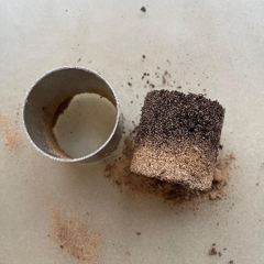
Kort na de brand was de bodem in de verbrande zones van Clinge sterker waterafstotend dan in de niet-verbrande delen. Regenwater dringt dan moeilijker in de bodem. Ook de bulkdichtheid, eenvoudig gezegd hoe compact de bodem is, lag lager.
Die verschillen werden in de maanden daarna kleiner. Een deel van de impact bleek dus tijdelijk. Ook de zuurtegraad veranderde: tijdens latere metingen, enkele maanden na de brand, was de verbrande bodem zuurder. Mogelijke verklaringen zijn het uitspoelen van bepaalde stoffen na regen en de beperkte buffercapaciteit van de zandgrond.
Zelfs een relatief weinig intense brand kan dus meetbare sporen nalaten onder het oppervlak.
Groen betekent niet automatisch hersteld
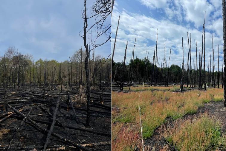
In april 2025 werden in het verbrande gebied zeven plantensoorten aangetroffen. Tegen maart 2026 waren dat er maximaal achttien. Ook de vegetatiebedekking nam sterk toe. Aan het einde van de onderzoeksperiode was ongeveer 40 procent van het verbrande gebied opnieuw begroeid.
Goed nieuws voor het bos? Niet noodzakelijk.
Een groot deel van dat nieuwe groen bestond grotendeels uit één soort: schapenzuring. Dat is een pionierssoort die zich goed voelt op droge, zure en verstoorde zandgronden. De soort kon de vrijgekomen ruimte na de brand bijzonder snel innemen.
Een dichte kruidachtige vegetatie kan jonge bomen hinderen in hun strijd om licht, water en ruimte. Ook Amerikaanse vogelkers, een invasieve exoot, werd in het verbrande gebied aangetroffen. Toch is er nog geen reden tot paniek, want het onderzoek duurde slechts één jaar. Bosherstel duurt jaren tot tientallen jaren. De toekomst zal moeten uitwijzen of het ecosysteem zich zelfstandig kan herstellen of niet.
Kan een satelliet zien waar het gebrand heeft?
Voor het tweede deel van mijn onderzoek verschoof de blik honderden kilometers omhoog. De Europese Sentinel-2-satellieten maken voortdurend beelden van het aardoppervlak en registreren daarbij meer dan wat met het blote oog zichtbaar is. Gezonde vegetatie en verbrande oppervlakken weerkaatsen licht namelijk op verschillende manieren.
Door verschillende delen van dat licht met elkaar te combineren, ontstaan zogenaamde spectrale indices: rekenformules die verbrande zones beter zichtbaar maken. Dat klinkt eenvoudig, maar in België is er een belangrijke uitdaging: natuurbranden zijn hier vaak relatief klein. Daardoor zijn ze moeilijker te onderscheiden op satellietbeelden dan de enorme branden die bijvoorbeeld in Zuid-Europa voorkomen.
Ik vergeleek verschillende van die indices voor vier brandgebieden. Welke methode het beste werkte, verschilde van plaats tot plaats, maar de beste resultaten kwamen telkens goed overeen met de werkelijk verbrande zones. Eén methode sprong er over de vier gebieden heen uit: de Normalized Burn Ratio (NBR). Die was niet op elke locatie afzonderlijk de beste, maar leverde wel goede en relatief consistente resultaten. Daardoor lijkt NBR veelbelovend voor een bredere toepassing bij het in kaart brengen van verbrande oppervlaktes.
En ziet de satelliet het bos ook herstellen?
Om het herstel na de brand op te volgen, gebruikte ik de Post-Fire Stability Index (PFSI). Die laat zien waar de vegetatie opnieuw toeneemt en hoe dat herstel doorheen de tijd verandert.
In de meeste gebieden was het sterkste herstel zichtbaar tijdens de eerste zomer na de brand. Toch verliep dat niet overal even snel: Maasmechelen liet een veel sterker herstelsignaal zien dan Houffalize.
Maar ook hier is nuance belangrijk. De PFSI kan goed tonen dat de vegetatie opnieuw toeneemt, maar niet automatisch welke soorten daarvoor verantwoordelijk zijn. Een gebied kan volgens deze index dus snel lijken te herstellen, terwijl dat herstel in werkelijkheid vooral wordt gedragen door één dominante soort. De index geeft met andere woorden een sterk beeld van de snelheid en ruimtelijke spreiding van vergroening, maar niet noodzakelijk van het volledige ecologische herstel.
Er is in België nog veel te leren over de ecologische gevolgen van natuurbranden. Langdurige opvolging blijft dan ook noodzakelijk, aangezien branden in de toekomst vaker een rol zullen spelen in onze natuur. Daarnaast wordt het steeds belangrijker om natuurbrandbeheer beter te integreren in bos- en natuurbeheer, waarbij een evenwicht nodig is tussen biodiversiteit, veerkracht van ecosystemen en het beperken van brandrisico’s.
Want wanneer de laatste vlam gedoofd is en de rook langzaam wegtrekt, begint het lange hoofdstuk: het herstellen van wat verloren ging.
Bibliografie
Adámek, M., Hadincová, V., Wild, J., and Van Diggelen, R. (2016). Long-term effect of wildfires on temperate Pinus sylvestris forests: vegetation dynamics and species diversity. Forest Ecology and Management, 380:285–295.
Agbeshie, A. A., Abugre, S., Atta-Darkwa, T., and Awuah, R. (2022). A review of the effects of forest fire on soil properties. Journal of Forestry Research, 33(5):1419 1441.
Akburak, S., Son, Y., Makineci, E., and Cakir, M. (2017). Impacts of low-intensity prescribed fire on microbial and chemical soil properties in a quercus frainetto forest. Journal of Forestry Research, 29(3):687–696.
Alcañiz, M., Outeiro, L., Francos, M., Farguell, J., and Úbeda, X. (2016). Long-term dy namics of soil chemical properties after a prescribed fire in a mediterranean forest (montgrí massif, catalonia, spain). Science of the Total Environment, 572:1329 1335.
Alcaras, E., Costantino, D., Guastaferro, F., Parente, C., and Pepe, M. (2022). Normal ized burn ratio plus (nbr+): A new index for sentinel-2 imagery. Remote Sensing, 14(7):1727.
Badía, D., Martí, C., Aguirre, A. J., Aznar, J. M., González-Pérez, J. A., De la Rosa, J. M., León, J., Ibarra, P., and Echeverría, T. (2014). Wildfire effects on nutrients and organic carbon of a rendzic phaeozem in ne spain: Changes at cm-scale topsoil. Catena, 113:267–275.
Baetens, J. M., Vancoillie, F., Coppens, F., Lejeune, P., Pau, M., et al. (2026). To wards scientifically supported and integrated Wildfire Management and Policy in Belgium. Technical report, Belgian Wildfire Network; Ghent University; Université de Liège, Belgium.
Bastarrika, A., Alvarado, M., Artano, K., Martinez, M. P., Mesanza, A., Torre, L., Ramo, R., and Chuvieco, E. (2014). Bams: A tool for supervised burned area mapping using landsat data. Remote Sensing, 6(12):12360–12380.
Berger, T. W. and Berger, P. (2012). Greater accumulation of litter in spruce (picea abies) compared to beech (fagus sylvatica) stands is not a consequence of the inherent recalcitrance of needles. Plant and Soil, 358(1–2):349–369.
Brye, K. R. (2006). Soil physiochemical changes following 12 years of annual burning in a humid–subtropical tallgrass prairie: a hypothesis. Acta Oecologica, 30:407–413.
Calle, P., Calle, L., Kuller, R., Walhout, J., Wieland, A., and van den Berg, N. (2023). Beheerplan waterwinbossen oost zeeuws-vlaanderen 2023–2034. Technical re port, Stichting Het Zeeuwse Landschap. Adopted in May 2023.
Caon, L., Vallejo, V. R., Ritsema, C. J., and Geissen, V. (2014). Effects of wildfire on soil nutrients in Mediterranean ecosystems. Earth-Science Reviews, 139:47–58. CERAC, ICEDD, VITO, Ramboll, Université de Liège, and Möbius (2025).
Risk to forest ecosystems from wildfire. Bcra technical paper, Climate and Environment Risk Assessment Centre (CERAC), Belgium.
Certini, G. (2005). Effects of fire on properties of forest soils: a review. Oecologia, 143:1–10. Chief, K., Young, M. H., and Shafer, D. S. (2012). Changes in soil structure and hydraulic properties in a wooded-shrubland ecosystem following a prescribed fire. Soil Science Society of America Journal, 76:1965–1977.
Clevers, J. G. P. W. and Gitelson, A. A. (2013). Remote estimation of crop and grass chlorophyll and nitrogen content using red-edge bands on sentinel-2 and-3. Inter national Journal of Applied Earth Observation and Geoinformation, 23:344–351.
Copernicus Data Space Ecosystem (2025). Forest fire analysis: Saving multiple results in one job. https://documentation.dataspace.copernicus.eu/APIs/ openEO/openeo-community-examples/python/ForestFire/ForestFire.html. Accessed: 11 April 2026. Copernicus Sentinel Wiki (n.d.).
Sentinel-2. https://sentiwiki.copernicus.eu/ web/sentinel-2. Accessed: 10 April 2026. DeBano, L. F., Neary, D. G., and Ffolliott, P. F. (1998).
Fire Effects on Ecosystems. John Wiley & Sons. Dekker, L. W. and Ritsema, C. J. (2009). Soil water repellency and its consequences for infiltration, erosion and preferential flow. Journal of Hydrology, 367(1–2):1–12.
Downing, T. A., Imo, M., Kimanzi, J., and Otinga, A. N. (2017). Effects of wildland fire on the tropical alpine moorlands of mount kenya. Catena, 149:300–308.
Dzwonko, Z., Loster, S., and Gawro´nski, S. (2015). Impact of fire severity on soil properties and the development of tree and shrub species in a scots pine moist forest site in southern poland. Forest Ecology and Management, 342:56–63.
Ecopedia (2026a). Ecopedia. https://www.ecopedia.be/. Accessed: 14 May 2026.
Ecopedia (2026b). Schapenzuring. schapenzuring. Accessed: 17 May 2026. https://www.ecopedia.be/planten/
Etchells, H., McCaw, L., Robinson, R., and Wardell-Johnson, G. (2020). Fire severity impacts on tree mortality and post-fire recruitment in tall eucalypt forests. Forest Ecology and Management, 474:118366.
European Commission, Civil Protection Humanitarian Aid Operations (2025). Wild fires. https://civil-protection-humanitarian-aid.ec.europa.eu/what/ civil-protection/wildfires_en. Accessed: 1 October 2025.
European Space Agency (2025a). Commercial and international data for fire monitoring. https://earth.esa.int/eogateway/success-story/ commercial-and-international-data-for-fire-monitoring. Accessed: 11 September 2025.
European Space Agency (2025b). Earth observation gateway. https://earth.esa. int/eogateway. Accessed: 1 March 2026.
Fernández-Manso, A., Fernández-Manso, O., and Quintano, C. (2016). Sentinel-2a red-edge spectral indices suitability for discriminating burn severity. International Journal of Applied Earth Observation and Geoinformation, 50:170–175.
Flora van Nederland (2021). Schapenzuring uit de duizendknoopfamilie. https:// www.floravannederland.nl/planten/schapenzuring. Accessed: 17 May 2026.
Flora van Nederland (2026). Flora van nederland. floravannederland.nl/. Accessed: 14 May 2026. https://www.
Gerard, F., Plummer, S., Wadsworth, R., Ferreruela Sanfeliu, A., Iliffe, L., Balzter, H., and Wyatt, B. (2003). Forest fire scar detection in the boreal forest with mul titemporal spot-vegetation data. IEEE Transactions on Geoscience and Remote Sensing, 41(11):2575–2585.
Gibson, R. K., White, L. A., Hislop, S., and Nolan, R. H. (2022). The post-fire stabil ity index; a new approach to monitoring post-fire recovery by satellite imagery. Remote Sensing of Environment, 280:113227.
Giovannini, G., Lucchesi, S., and Giachetti, M. (1988). Effect of heating on some physical and chemical parameters related to soil aggregation and erodibility. Soil Science, 146(4):255–261.
Gitas, I., Mitri, G., Veraverbeke, S., and Polychronaki, A. (2012). Advances in remote sensing of post-fire vegetation recovery monitoring– a review. In Thenkabail, P. S., editor, Remote Sensing of Biomass– Principles and Applications, chapter 7. IntechOpen.
Goberna, M., García, C., Insam, H., and Hernández, M. T. (2007). Burning fire-prone mediterranean shrublands: Immediate changes in soil microbial community struc ture. Soil Biology and Biochemistry, 39(2):340–348.
González-Pérez, J. A., González-Vila, F. J., Almendros, G., and Knicker, H. (2004). The effect of fire on soil organic matter—a review. Environment International, 30(6):855–870.
Granged, A. J. P., Zavala, L. M., Jordán, A., and Bárcenas-Moreno, G. (2011). Post-fire evolution of soil properties and vegetation cover in a mediterranean heathland after experimental burning: A 3-year study. Geoderma, 164:85–94.
Haire, S. L. and McGarigal, K. (2010). Effects of landscape patterns of fire severity on regenerating ponderosa pine forests (pinus ponderosa) in new mexico and arizona, usa. Landscape Ecology, 25(7):1055–1069.
Heydari, M., Rostamy, A., Najafi, F., and Dey, D. C. (2016). Effect of fire severity on physical and biochemical soil properties in zagros oak (quercus brantii lindl.) forests in iran. Journal of Forestry Research.
Hislop, S., Jones, S., Soto-Berelov, M., Skidmore, A., Haywood, A., and Nguyen, T. H. (2018). Using landsat spectral indices in time-series to assess wildfire disturbance and recovery. Remote Sensing, 10(3):460.
Hosseini, M. and Lim, S. (2023). Burned area detection using sentinel-1 sar data: A case study of kangaroo island, south australia. Applied Geography, 151:102854.
Inbar, A., Lado, M., Sternberg, M., Tenau, H., and Ben-Hur, M. (2014). Forest fire effects on soil chemical and physicochemical properties, infiltration, runoff, and erosion in a semiarid mediterranean region. Geoderma, 221–222:131–138.
Jacquemyn, H., Brys, R., and Neubert, M. G. (2005). Fire increases invasive spread of molinia caerulea mainly through changes in demographic parameters. Ecological Applications, 15(6):2097–2108.
Johnson, D. W. and Curtis, P. S. (2001). Effects of forest management on soil c and n storage: meta analysis. Forest Ecology and Management, 140(2–3):227–238.
Jordán, A., Zavala, L., Gil, J., and Roldán, J. M. (2013). Effect of fire severity on water repellency and aggregate stability on mediterranean shrubland soils. Catena, 108:14–22.
Keeley, J. E. (2009). Fire intensity, fire severity and burn severity: a brief review and suggested usage. International Journal of Wildland Fire, 18(1):116–126.
Key, C. H. and Benson, N. C. (2006). Landscape assessment: Sampling and analysis methods. General Technical Report RMRS-GTR-164, U.S. Department of Agricul ture, Forest Service, Rocky Mountain Research Station, Fort Collins, CO.
Koninklijk Meteorologisch Instituut van België (2025). Klimaatstatistieken van de belgische gemeenten: Sint-gillis-waas (referentieperiode 1991–2020). https:// www.meteo.be. Accessed from climate statistics report for Sint-Gillis-Waas.
Korets, M. A., Ryzhkova, V. A., Danilova, I. V., Sukhinin, A. I., and Bartalev, S. A. (2010). Forest disturbance assessment using satellite data of moderate and low resolution. In Balzter, H., editor, Environmental Change in Siberia: Earth Observa tion, Field Studies and Modelling, pages 3–19. Springer Netherlands, Dordrecht.
Lillesand, T. M., Kiefer, R. W., and Chipman, J. W. (2015). Remote Sensing and Image Interpretation. John Wiley Sons, Hoboken, NJ, 7th edition.
Liu, J., Qiu, L., Wang, X., Wei, X., Gao, H., Zhang, Y., and Cheng, J. (2018). Effects of wildfire and topography on soil nutrients in a semiarid restored grassland. Plant and Soil, 423(1–2):123–138.
Magomani, M.I. andvanTol, J. J. (2018). The impact of fire frequency on selected soil physical properties in a semi-arid savannah thornveld. Acta Agriculturae Scandi navica, Section B — Soil Plant Science.
Martín Isabel, M. d. P. and Chuvieco Salinero, E. (1998). Cartografía de grandes incendios forestales en la península ibérica a partir de imágenes noaa–avhrr. Serie Geográfica, 7:109–128.
Meira-Castro, A., Shakesby, R. A., Marques, J. E., Doerr, S. H., Meixedo, J. P., Teix eira, J., and Chaminé, H. I. (2015). Effects of prescribed fire on surface soil in a pinus pinaster plantation, northern portugal. Environmental Earth Sciences, 73(7):3005–3018.
Millar, C. I. and Stephenson, N. L. (2015). Temperate forest health in an era of emerging megadisturbance. Science, 349(6250):823–826.
Moreira, A., Prats-Iraola, P., Younis, M., Krieger, G., Hajnsek, I., and Papathanassiou, K. P. (2013). A tutorial on synthetic aperture radar. IEEE Geoscience and Remote Sensing Magazine, 1(1):6–43.
Mpakairi, K. S., Tagwireyi, P., and Murwira, A. (2020). Exploring the utility of sentinel 2 msi derived spectral indices for burned area detection. Remote Sensing Appli cations: Society and Environment, 20:100364.
Muqaddas, B., Zhou, X., Lewis, T., Wild, C., and Chen, C. (2015). Long-term frequent prescribed fire decreases surface soil carbon and nitrogen pools in a wet sclero phyll forest of southeast queensland, australia. Science of the Total Environment, 536:39–47.
NASA Earthdata (2024). Synthetic aperture radar (sar) and polarization. https:// www.earthdata.nasa.gov/learn/earth-observation-data-basics/sar. Ac cessed: 26 February 2026.
Neary, D. G., Klopatek, C. C., DeBano, L. F., and Ffolliott, P. F. (1999). Fire effects on belowground sustainability: a review and synthesis. Forest Ecology and Manage ment, 122:51–71.
Osman, K. T. (2018). Management of Soil Problems. Springer International Publish ing, Cham, Switzerland.
Owen, S. M., Sieg, C. H., Sánchez Meador, A. J., Fulé, P. Z., Iñiguez, J. M., Baggett, L. S., Fornwalt, P. J., and Battaglia, M. A. (2017). Spatial patterns of ponderosa pine regeneration in high-severity burn patches. Forest Ecology and Management, 405:134–149.
Pérez, C. C., Olthoff, A. E., Hernández-Trejo, H., and Rullán-Silva, C. D. (2022). Evalu ating the best spectral indices for burned areas in the tropical pantanos de centla biosphere reserve, southeastern mexico. Remote Sensing Applications: Society and Environment, 25:100664.
Perkovi´c, I., Pernar, N., Roje, V., Bakˇ si´c, D., and Banekovi´c, M. (2019). Impacts of norway spruce (picea abies l., h. karst.) stands on soil in continental croatia. iForest- Biogeosciences and Forestry, 12:511–517.
Rajapaksha, R. A. N. D., Leelamanie, D. A. L., and Mori, Y. (2025). Heat-induced changes in water repellency of litter ash: role of organic functional groups as determined by ftir spectroscopy. Science of the Total Environment, 981:179594.
Rokhmatuloh, R., Sari, N. M., Siregar, V. P., Lubis, M. Z., Ramdhan, M., and Prayogo, T. (2022). Burnt-area quick mapping method with synthetic aperture radar data. Applied Sciences, 12(23):11922.
Roy, D. P. and Landmann, T. (2005). Characterizing the surface heterogeneity of fire effects using multi-temporal reflective wavelength data. International Journal of Remote Sensing, 26(19):4197–4218.
Santín, C., Doerr, S. H., Shakesby, R. A., Bryant, R., Sheridan, G. J., Lane, P. N. J., Smith, H. G., and Bell, T. L. (2012). Carbon loads, forms and sequestration poten tial within ash deposits produced by wildfire: new insights from the 2009 ‘black saturday’ fires, australia. European Journal of Forest Research, 131(4):1245 1253.
Scharenbroch, B. C., Nix, B., Jacobs, K. A., and Bowles, M. L. (2012). Two decades of low-severity prescribed fire increases soil nutrient availability in a midwestern, usa oak (quercus) forest. Geoderma, 183–184:80–91.
Schepers, L., Haest, B., Veraverbeke, S., Spanhove, T., Vanden Borre, J., and Goossens, R. (2014). Burned area detection and burn severity assessment of a heathland fire in belgium using airborne imaging spectroscopy (apex). Remote Sensing, 6(3):1803–1826.
Silvestre, M. D. (2021). Detecting small wildfires in the netherlands through sentinel-2 data. Master’s thesis, Wageningen University Research, Wageningen, The Netherlands.
Slaton, M. R., Hunt, E. R. J., and Smith, W. K. (2001). Estimating near-infrared leaf reflectance from leaf structural characteristics. American Journal of Botany, 88(2):278–284.
Stichting Het Zeeuwse Landschap (2025). Natuurherstel en onderzoek na bosbrand clingse bossen. https://www.hetzeeuwselandschap.nl/actueel/ natuurherstel-en-onderzoek-na-bosbrand-clingse-bossen. Accessed: 30 April 2026.
Stoof, C. R., Moore, D., Ritsema, C. J., and Dekker, L. W. (2011). Natural and fire induced soil water repellency in a portuguese shrubland. Soil Science Society of America Journal, 75(6):2283–2295.
Storey, E. A., Stow, D. A., and O’Leary, J. F. (2016). Assessing postfire recovery of chamise chaparral using multi-temporal spectral vegetation index trajectories derived from landsat imagery. Remote Sensing of Environment, 183:53–64.
Teale, S. A. and Castello, J. D. (2011). The past as key to the future: A new perspec tive on forest health. Journal of Forestry, 109(8):458–466.
Teste, F. P., Simard, S. W., Durall, D. M., Guy, R. D., Jones, M. D., and Schoonmaker, A. L. (2009). Access to mycorrhizal networks and roots of trees: importance for seedling survival and resource transfer. Ecology, 90(10):2808–2822.
Tian, D. and Niu, S. (2015). A global analysis of soil acidification caused by nitrogen addition. Environmental Research Letters, 10(2):024019.
Torres, J., Gonçalves, J., Marcos, B., and Honrado, J. (2018). Indicator-based assess ment of post-fire recovery dynamics using satellite ndvi time-series. Ecological Indicators, 89:199–212.
Turner, M. G., Baker, W. L., Peterson, C. J., and Peet, R. K. (1998). Factors influencing succession: Lessons from large, infrequent natural disturbances. Ecosystems, 1(6):511–523.
Van Ranst, E., Verloo, M., Demeyer, A., and Pauwels, J. M. (1999). Manual for the Soil Chemistry and Fertility Laboratory: Analytical Methods for Soils and Plants, Equipment, and Management of Consumables. NUGI 835, Ghent, Belgium.
Varela, M. E., Benito, E., and Keizer, J. J. (2015). Influence of wildfire severity on soil physical degradation in two pine forest stands of nw spain. Catena, 133:342–348.
VRT NWS (2025). Bosbrand bij de klinge. aan belgisch-nederlandse grens https://www.vrt.be/vrtnws/nl/2025/03/23/ bosbrand-brand-de-klinge-brandweer/. Accessed: 8 May 2026.
Weather Underground (2026). Personal weather station dashboard: Isintj5. https: //www.wunderground.com/dashboard/pws/ISINTJ5. Accessed: 4 May 2026.
Weil, R. R. and Brady, N. C. (2017). The Nature and Properties of Soils. Pearson Education Limited, Harlow, England, 15th global edition.
Yakubu, I., Mireku-Gyimah, D., and Duker, A. A. (2015). Review of methods for modelling forest fire risk and hazard. African Journal of Environmental Science and Technology, 9(3):155–165.
Zegrar, A., Bentekhici, N., Saad, A., and Shraoui, O. H. (2025). Assessment and monitoring of post-fire recovery using satellite imagery and the stability index in the north west of algeria. In EGU General Assembly 2025, Vienna, Austria. European Geosciences Union. Conference presentation.