De kust onder stroom
Grondwater is onze belangrijkste bron van drinkbaar water. In kustgebieden wordt deze reserve bedreigd door de aanwezigheid van de zoutwater intrusie, een overgangszone tussen het zoute zeewater en het zoete – drinkbaar – water. Maar liefst 70 % van de wereldbevolking leeft in kustgebieden. Het is dus belangrijk om de mechanismen achter dit fenomeen uit de doeken te doen om zo onze grondwater reserves te beschermen met het oog op de toekomstige generaties.
- Zoutwater intrusie
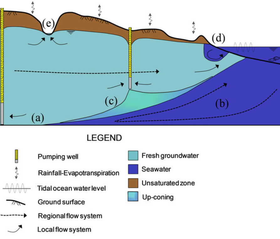
De zoutwater intrusie is een proces waarbij zout grondwater – afkomstig van de zee – het land indringt en zoet grondwater richting de zee stroomt. Door het densiteit verschil ontstaat er een wig van zwaarder zout water onder lichter zoet water. Dit fenomeen werd reeds uitgebreid bestudeerd, waaruit blijkt dat de locatie afhangt van het zeeniveau. Fenomenen zoals zeespiegelstijging en getijdenwerking hebben dus een invloed op de locatie en vorm van de intrusie.
De methode bij uitstek voor het bestuderen en monitoren van de intrusie is elektrische resistiviteit tomografie (ERT), de voorgenoemde observaties zijn echter gemaakt doormiddel van chemische analyses en geofysische metingen in boorputten. Het doel van deze scriptie is om de mogelijkheid te toetsen om ERT te gebruiken voor het visualiseren van de getijdenvariaties. Naar de kennis van de auteurs is een gelijkaardige studie nog nooit uitgevoerd.
- Unieke situatie in België
Langs de Belgische kust heeft de zoutwater intrusie een unieke vorm. In natuurgebied de Westhoek – gelegen langs de Franse grens – ligt er een zoutwater lens bovenop een zoetwater tong. Op het eerste zicht lijkt deze inverse densiteit distributie niet stabiel maar het omgekeerde is waar. Uit modellering blijkt dat deze situatie zich in een dynamisch evenwicht bevindt doordat verschillende grondwater stromingen op elkaar inwerken. De zoutwater intrusie in de Westhoek is zeer gedetailleerd bestudeerd in het verleden waardoor we dit gebied gekozen hebben in het raam van de scriptie.
- Hoe werkt ERT?
Elektrische resistiviteit tomografie – een moeilijke term die wil zeggen dat je door middel van elektrische stromen een beeld van de ondergrond kan maken. Een stroom wordt in de grond geïnjecteerd tussen twee elektroden (het zendend elektrodepaar), tussen twee andere elektroden wordt dan het potentiaalverschil gemeten (het ontvangend electrodepaar). Het gemeten verschil hangt af van de elektrische eigenschappen van de ondergrond, gebieden met hoge en lage geleidbaarheid kunnen dan goed geïdentificeerd worden. Doordat zout water een veel hogere geleidbaarheid heeft dan zoet water kunnen de twee duidelijk onderscheiden worden in een ERT-profiel.
- Problemen en oplossingen
Monitoren van de zoutwater intrusie tijdens een getijdencyclus brengt enkele problemen met zich mee die het gevolg zijn van de getijdenwerking. Tijdens hoogtij is een deel van de opstelling bedekt met zeewater, bij laagtij is dit droog. Door de aanwezigheid van de laag met sterk geleidbaar zeewater gaat een groot deel van de stroom hierin verloren. Dit zorgt ervoor dat profielen die vergaard zijn tijdens hoogtij een slechtere resolutie hebben dan profielen gemeten tijdens laagtij. Wat het moeilijk zal maken variaties te bestuderen. Het meten van een profiel kan enkele tientallen minuten duren, wanneer een profiel gemeten wordt tijden hoog- of laagtij is het zeeniveau stabiel en doen zich geen extra problemen voor. Echter tijdens de getijdenwisseling is de opstelling variabel bedekt met zeewater tijdens één meting, wat een extra moeilijkheidsgraad met zich meebrengt.
We hebben dit probleem aangepakt in twee fasen: eerst hebben we een synthetische studie uitgevoerd om het effect van de waterlaag in te schatten. Waarna we op het veld gestapt zijn om de metingen uit te voeren en te zien als het mogelijk is om te monitoren in dit type omgeving.
- Het onderzoek zelf – aanpak en resultaten
Voor de synthetische studie werd een model gemaakt dat de situatie in de Westhoek nabootst. Om het effect van het opkomend water in te schatten is het voldoende om een halve getijdencyclus te reconstrueren. Verschillende algoritmen werden gebruikt om de data te verwerken, hieruit blijkt dat de beste resultaten bekomen worden wanneer een referentie model meegenomen wordt in de inversie. Dit wil zeggen dat er rekening gehouden wordt met extra informatie over het studiegebied, in dit geval wordt de waterlaag expliciet gedefinieerd wat de resultaten significant verbeterd. Verder is de invloed van de waterlaag duidelijk te zien in de profielen. Het verlies in resolutie wordt gereflecteerd door de aanwezigheid van artefacten in de hoogwater profielen.
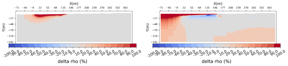
Voor de veldstudie werden twee profielen in de Westhoek gemonitord gedurende drie dagen. Een lang profiel om diepe variaties te detecteren en een kort profiel om in meet detail naar de overgangszone te kijken. De data werd verwerkt zoals gesuggereerd in de synthetische studie (met een referentie model) en de resultaten zijn gelijkaardig. Ook hier heeft de waterlaag een sterke – negatieve – invloed op de resultaten. Zowel in de lange als korte profielen zijn kleine variaties aanwezig, maar door het resolutie verlies is het moeilijk om artefacten te onderscheiden van echte variaties. Wat we wel konden onderscheiden is een her-saturatie van het sediment voor de opstelling bedekt was met zeewater, een observatie die voordien nog niet gemaakt is.
Het grootste probleem hier is de aanwezigheid van artefacten door de waterlaag, dit kan mogelijks opgelost worden door nog dieper in te gaan op andere verwerking algoritmen. Deze pilootstudie toont al aan dat ERT-monitoring in een dynamische omgeving mogelijk is maar dat er toch nog een aantal struikelblokken zijn. In het kort: het is een veelbelovende methode die de manier waarop we zoutwater intrusie bestuderen drastisch kan veranderen.
Bibliografie
ABEM Instrument AB (2012). Instruction Manual Terrameter LS. 33. Sundbyberg, Sweden, p. 122.
Archie, G. E. (1942). “The Electrical Resistivity Log as an Aid in Determining Some Reservoir Characteristics". In: Transactions AIME 146, pp. 54-62.
Badon-Ghyben, W. (1888). “Nota in verband met de voorgenomen putboring nabij Amsterdam". In: Tijdschrijt van het Koninklijk Instituut van Ingenieurs 1888/9, pp. 8-22.
Barlow, P. M. and Reichard, E. G. (2010). “Saltwater intrusion in coastal regions of North America". In: Hydrogeology Journal 18, pp. 247-260.
Bear, J., Cheng, A.-D., Sorek, S., Ouazar, D., and Herrera, I. (1999). Seawater Intrusion in Coastal Aquifers - Concepts, Methods and Pracices. 14th ed., p. 626.
Benoit, S., Ghysels, G., Gommers, K., Hermans, T., Nguyen, F., and Huysmans, M. (2019). “Characterization of spatially variable riverbed hydraulic conductivity using electrical resistivity tomography and induced polarization". In: Hydrogeology Journal 27.1, pp. 395-407.
Casas, A., Himi, M., Diaz, Y., Pinto, V., Font, X., and Tapias, J. (2008). “Assessing aquifer vulnerability to pollutants by electrical resistivity tomography ( ERT ) at a nitrate vulnerable zone in NE Spain". In: Environmental Geology 54, pp. 515-520.
Caterina, D., Beaujean, J., Robert, T., and Nguyen, F. (2013). “A comparison study of different image appraisal tools for electrical resistivity tomography". In: Near Surface Geophysics 11.6, pp. 639-657.
Caterina, D., Hermans, T., and Nguyen, F. (2014). “Case studies of incorporation of prior information in electrical resistivity tomography: Comparison of di_erent approaches". In: Near Surface Geophysics 12.4, pp. 451-465.
Chang, S. W., Clement, T. P., Simpson, M. J., and Lee, K. K. (2011). “Does sea-level rise have an impact on saltwater intrusion?" In: Advances in Water Resources 34.10, pp. 1283-1291.
Constable, S. C., Parker, R. L., and Constable, C. G. (1987). “Models From Electromagnetic Sounding Data". In: Geophysics 52.3, pp. 289-300.
Dahlin, T. and Zhou, B. (2004). “A numerical comparison of 2D resistivity imaging with 10 electrode arrays". In: Geophysical Prospecting 52.5, pp. 379-398.
Dahlin, T. and Zhou, B. (2006). “Multiple-gradient array measurements for multichannel 2D resistivity imaging". In: Near Surface Geophysics 4.2, pp. 113-123.
Doetsch, J., Linde, N., Pessognelli, M., Green, A. G., and Gunther, T. (2012). “Constraining 3-D electrical resistance tomography with GPR re ection data for improved aquifer characterization". In: 78, pp. 68-76.
Dumont, G., Pilawski, T., Dzaomuho-Lenieregue, P., Hiligsmann, S., Delvigne, F., Thonart, P., Robert, T., Nguyen, F., and Hermans, T. (2016). “Gravimetric water distribution assessment from geoelectrical methods (ERT and EMI) in municipal solid waste landfill". In: Waste Management 55, pp. 129-140.
Eijkelkamp: Soil and Water (2016). Product Manual: Diver. Giesbeek, The Netherlands, p. 26.
Eurostat (2011). “Coastal regions". In: Eurostat regional yearbook, pp. 169-183.
FAO (1997). Seawater intrusion in coastal aquifers: Guidelines for study, monitoring and control. Rome, Italy.
Felisa, G., Ciriello, V., and Di Federico, V. (2013). “Saltwater intrusion in coastal aquifers: A primary case study along the adriatic coast investigated within a probabilistic framework".In: Water (Switzerland) 5.4, pp. 1830-1847.
Goebel, M., Pidlisecky, A., and Knight, R. (2017). “Resistivity imaging reveals complex pattern of saltwater intrusion along Monterey coast". In: Journal of Hydrology 551, pp. 746-755.
Gonneea, M. E., Mulligan, A. E., and Charette, M. A. (2013). “Climate-driven sea level anomalies modulate coastal groundwater dynamics and discharge". In: Geophysical Research Letters 40.11, pp. 2701-2706.
Grunhut, V., Bongiovanni, M., and Osella, A. (2018). “Using surface-downhole ERT for detecting contaminants in deep aquifers due to exploitation of oil reservoirs". In: Near Surface Geophysics 16.5, pp. 559-571.
Henderson, R. D., Day-Lewis, F. D., Abarca, E., Harvey, C. F., Karam, H. N., Liu, L., and
Lane, J. W. (2010). “Marine electrical resistivity imaging of submarine groundwater discharge: sensitivity analysis and application in Waquoit Bay, Massachusetts, USA". In: Hydrogeology Journal 18.1, pp. 173-185.
Hermans, T. and Paepen, M. (2020). “Combined Inversion of Land and Marine Electrical Resistivity Tomography for Submarine Groundwater Discharge and Saltwater Intrusion Characterization". In: Geophysical Research Letters 47.3, pp. 1-9.
Hermans, T., Vandenbohede, A., Lebbe, L., Martin, R., Kemna, A., Beaujean, J., and Nguyen, F. (2012). “Imaging arti_cial salt water in_ltration using electrical resistivity tomography constrained by geostatistical data". In: Journal of Hydrology 438-439, pp. 168-180.
Hermans, T., Wildemeersch, S., Jamin, P., Orban, P., Brouy_ere, S., Dassargues, A., and Nguyen, F. (2015). “Quantitative temperature monitoring of a heat tracing experiment using crossborehole ERT". In: Geothermics 53, pp. 14-26.
Hermans, T. J. (2014). “Integration of near-surface geophysical, geological and hydrogeological data with multiple-point geostatistics in alluvial aquifers". PhD thesis, p. 297.
Herzberg, A. (1901). “DieWasserversorgung einiger Nordseebder." In: Z. Gasbeleucht. Wasserversorg. 44, pp. 815-819.
Lebbe, L. (1981). “The subterranean ow of fresh and salt water underneath the western Belgian beach. 7th salt water intrusion meeting, Uppsala." In: Sver Geol Unders Rap Meddel 27, pp. 193-219.
Lesparre, N., Nguyen, F., Kemna, A., Robert, T., Hermans, T., Daoudi, M., and Flores-Orozco, A. (2017). “A new approach for time-lapse data weighting in ERT". In: Geophysics 82.6.
Loke, M. H., Chambers, J. E., Rucker, D. F., Kuras, O., and Wilkinson, P. B. (2013). “Recent developments in the direct-current geoelectrical imaging method". In: Journal of Applied Geophysics 95, pp. 135-156.
Lowrie, W. (2007). Fundamentals of Geophysics. 2nd ed. New York: Cambridge University Press, p. 384.
Michael, H. A., Mulligan, A. E., and Harvey, C. F. (2005). “Seasonal oscillations in water exchange between aquifers and the coastal ocean". In: Nature 436.7054, pp. 1145-1148.
Miller, C. R., Routh, P. S., Brosten, T. R., and McNamara, J. P. (2008). “Application of timelapse ERT imaging to watershed characterization". In: Geophysics 73.3.
Morrow, F. J., Ingham, M. R., and McConchie, J. A. (2010). “Monitoring of tidal inuences on the saline interface using resistivity traversing and cross-borehole resistivity tomography". In: Journal of Hydrology 389.1-2, pp. 69-77.
Negri, S., Leucci, G., and Mazzone, F. (2008). “High resolution 3D ERT to help GPR data interpretation for researching archaeological items in a geologically complex subsurface". In: Journal of Applied Geophysics 65.3-4, pp. 111-120.
Neumann, B., Vafeidis, A. T., Zimmermann, J., and Nicholls, R. J. (2015). “Future coastal population growth and exposure to sea-level rise and coastal ooding - A global assessment". In: PLoS ONE 10.3.
Nguyen, F., Kemna, A., Antonsson, A., Engesgaard, P., Kuras, O., Ogilvy, R., Gisbert, J., Jorreto, S., and Pulido-Bosch, A. (2009). “Characterization of seawater intrusion using 2D electrical imaging". In: Near Surface Geophysics 7.5-6, pp. 377-390.
Nguyen, F., Kemna, A., Robert, T., Hermans, T., Daoudi, M., and Flores-Orozco, A. (2011). “Inversion of multi-temporal geoelectrical data sets: insights from several case studies."In: 1st Workshop on Geoelectrical monitoring, GELMON. Vienna, Austria.
Nguyen, F., Kemna, A., Robert, T., and Hermans, T. (2016). “Data-driven selection of the minimum-gradient support parameter in time-lapse focused electric imaging". In: Geophysics 81.1, A1-A5.
Oldenburg, D. W. and Li, Y. (1994). “Subspace linear inverse method". In: Inverse Problems 10.4, pp. 915-935.
Oude Essink, G. H., Van Baaren, E. S., and De Louw, P. G. (2010). “Effects of climate change on coastal groundwater systems: A modeling study in the Netherlands". In: Water Resources Research 46.10, pp. 1-16.
Paepe, R. and Baeteman, C. (1979). “The Belgian coastal plain during the Quaternary". In: The Quaternary History of the North Sea, pp. 143-146.
Paepen, M., Hanssens, D., De Smedt, P., Walraevens, K., and Hermans, T. (2020). “Combining resistivity and frequency domain electromagnetic methods to investigate submarine groundwater discharge (SGD) in the littoral zone". In: Hydrology and Earth System Sciences Discussions 24, pp. 3539-3555.
Parasnis, D. S. (1988). “Reciprocity theorems in geoelectric and geoelectromagnetic work". In: Geoexploration 25.3, pp. 177-198.
Revil, A., Karaoulis, M., Johnson, T., and Kemna, A. (2012). “Review: Some low-frequency electrical methods for subsurface characterization and monitoring in hydrogeology". In: Hydrogeology Journal 20.4, pp. 617-658.
Reynolds, J. M. (2011). An introduction to applied and environmental geophysics, p. 696.
Robert, T., Caterina, D., Deceuster, J., Kaufmann, O., and Nguyen, F. (2012). “A salt tracer test monitored with surface ERT to detect preferential ow and transport paths in fractured/ karstiffed limestones". In: Geophysics 77.2.
Ronczka, M., Vo_, T., and Gunther, T. (2015). “Cost-efficient imaging and monitoring of saltwater in a shallow aquifer by using long electrode ERT". In: Journal of Applied Geophysics 122, pp. 202-209.
Rubio-melendi, D., Gonzalez-quir_os, A., Roberts, D., Garc__a Garc__a, M. d. C., Caunedo Dom__niguez, A., Pringle, J. K., and Fern_andez-_alvarez, J.-p. (2018). “Case Report GPR and ERT detection and characterization of a mass burial , Spanish". In: Forensic Science International 287, e1-e9. url: https://doi.org/10.1016/j.forsciint.2018.03.034.
Sasaki, Y. (1994). “3-D resistivity inversion using the _nite-element method". In: Geophysics 59.12, pp. 1839-1848.
Singha, K., Day-Lewis, F. D., Johnson, T., and Slater, L. D. (2015). “Advances in interpretation of subsurface processes with time-lapse electrical imaging". In: Hydrological Processes 29.6,pp. 1549-1576.
Slater, L., Binley, A. M., Daily, W., and Johnson, R. (2000). “Cross-hole electrical imaging of a controlled saline tracer injection". In: Journal of Applied Geophysics 44.2-3, pp. 85-102.
Sudha, K., Israil, M., Mittal, S., and Rai, J. (2009). “Soil characterization using electrical resistivity tomography and geotechnical investigations". In: Journal of Applied Geophysics 67.1, pp. 74-79.
Swarzenski, P. W., Burnett, W. C., Greenwood, W. J., Herut, B., Peterson, R., Dimova, N., Shalem, Y., Yechieli, Y., and Weinstein, Y. (2006). “Combined time-series resistivity and geochemical tracer techniques to examine submarine groundwater discharge at Dor Beach, Israel". In: Geophysical Research Letters 33.24, pp. 1-6.
Taniguchi, M., Burnett, W. C., Cable, J. E., and Turner, J. V. (2002). “Investigation of submarine groundwater discharge". In: Hydrological Processes 16.11, pp. 2115-2129.
Taniguchi, M., Ishitobi, T., and Shimada, J. (2006). “Dynamics of submarine groundwater discharge and freshwater-seawater interface". In: Journal of Geophysical Research: Oceans 111.1.
Telford, W., Geldart, L., and Sheri_, R. (1990). Applied Geophysics. Second edi. Cambridge, U.K.: Cambridge University Press, p. 728.
Tikhonov, A. N., Goncharsky, A. V., Stepanov, V. V., and Yagola, A. G. (1995). Numerical Methods for the Solution of Ill-Posed Problems.
USGS (2000). Ground-Water for the Future - Atlantic Coastal Zone.
Vandenbohede, A., Lebbe, L., Gysens, S., Delecluyse, K., and DeWolf, P. (2008). “Salt water infiltration in two arti_cial sea inlets in the Belgian dune area". In: Journal of Hydrology 360.1-4, pp. 77-86.
Vandenbohede, A., Courtens, C., Lebbe, L., and Breuck, W. de (2010). “Fresh-salt water distribution in the central Belgian coastal plain: An update". In: Geologica Belgica 13.3, pp. 163-172.
Vandenbohede, A. and Lebbe, L. (2006). “Occurrence of salt water above fresh water in dynamic equilibrium in a coastal groundwater ow system near De Panne, Belgium". In: Hydrogeology Journal 14.4, pp. 462-472.
Vandenbohede, A. and Lebbe, L. (2007). “E_ects of tides on a sloping shore: Groundwater dynamics and propagation of the tidal wave". In: Hydrogeology Journal 15.4, pp. 645-658.
Verwaest, T., De Wolf, P., Herrier, J., and Leten, M. (2005). “Windows in the dunes - the creation of sea inlets in the nature reserve de Westhoek in de Panne". In: Proceedings
“Dunes end Estuaries 2005" - International Conference on Nature Restoration Practices in European Coastal Habitats, ed. by J.-L. Herrier, J. Mees, A. Salman, J. Seys, H. Van Nieuwenhuyse, and I. Dobbelare. Koksijde, Belgium, 19-23 September 2005, vol. 19.: VLIZ Special Publication, pp. 433-439.
Waxman, M. and Smits, L. (1968). “Electrical conductivities in oil-bearing shaly sands." In: Society of Petroleum Engineers Journal 8, pp. 107-122.
Werner, A. D., Bakker, M., Post, V. E., Vandenbohede, A., Lu, C., Ataie-Ashtiani, B., Simmons, C. T., and Barry, D. A. (2013). “Seawater intrusion processes, investigation and management: Recent advances and future challenges". In: Advances in Water Resources 51, pp. 3-26.
Werner, A. D. and Simmons, C. T. (2009). “Impact of sea-level rise on sea water intrusion in coastal aquifers". In: Ground Water 47.2, pp. 197-204.
White, J. and Roberts, T. (1994). “The signi_cance of groundwater tidal uctuations". In: Groundwater problems in urban areas. Ed. by W. Wilkinson. London: Thomas Telford. Chap. 2, pp. 31-42.
WHO (2011). Guidelines for Drinking-water Quality. 4th ed., p. 541.
Zhang, G., Lu, Q.-T., Zhang, G.-B., Ling, P.-R., Jia, Z.-Y., and Sue, K. (2018). “Joint Interpretation of Geological , Magnetic , AMT , and ERT Data for Mineral Exploration in the Northeast of Inner Mongolia , China". In: 175, pp. 989-1002.