Op zoek naar groen in Vlaanderen
We wonen met steeds meer in steeds grotere steden. Vandaag heeft slechts één Vlaming op twee toegang tot publiek groen op wandelafstand. Het belang van publiek groen kan simpelweg niet voldoende benadrukt worden. Daarom ontwikkelden we voor deze masterscriptie een kaart die de toegang tot publiek groen in Vlaanderen blootlegt.
 Toegankelijke groene plekjes zoals parken en bossen vallen onder de noemer van ‘publiek groen’: groen dat bereikbaar en toegankelijk is via het wegennetwerk. Wetenschappers en gezondheidsinstellingen zijn steeds meer overtuigd dat toegang tot groene ruimtes talloze gezondheidsvoordelen biedt. Maar, hoe meet en weet je nu of we voldoende publiek groen binnen ons bereik hebben? En hoe zit het met dat publiek groen in Vlaanderen? Met die vragen gingen we aan de slag.
Publiek groen – boeit mij niet?!
Publiek groen - boeit jou dat eigenlijk? Het zou moeten! Onderzoek heeft aangetoond dat parken en bossen essentieel zijn voor het verminderen van stedelijke uitdagingen zoals hitte-eilanden en luchtvervuiling. Ze bieden verder ook diverse directe voordelen voor je fysieke en mentale gezondheid. Zo is het bewezen dat met meer groen om je heen, je meer sport, een betere concentratie hebt en beter sociale connecties legt. Daarom is het belangrijk dat beleidsmakers ervoor zorgen dat iedereen voldoende toegang heeft tot publiek groen. Dit begint met het begrijpen van de huidige situatie en het vinden van manieren om de toegang tot publiek groen te meten.
Groen in kaart
Het meten van de toegang tot publiek groen in Vlaanderen stuit op één groot probleem: het ontbreken van een eenduidige groenkaart. Het lijkt evident om alle publiek groen in Vlaanderen in kaart te brengen, maar dat is het niet. Slechts een deel van de gemeenten houdt data bij over hun publiek groen, en daarbij gebruiken ze vaak verschillende definities. De oplossing bleek uit onverwachte hoek te komen. Via de toepassing OpenStreetMap verzamelen burgers al jaren informatie over hun omgeving. Op basis van verschillende steekproeven toonden we aan dat hun informatie over publiek groen een verrassend betrouwbare basis vormt voor een tot nu toe ontbrekende kaart van publiek groen in Vlaanderen. Op basis van deze data creëerden we een kaart met publiek groen in Vlaanderen. Hieruit bleek dat 9% van Vlaanderen bestaat uit publiek groen. Dit is echter slecht verdeeld en de overgrote meerderheid bevindt zich in het oosten.
Opstap naar de index
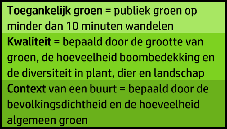 Hoe meet je nu met deze kaart of we voldoende publiek groen binnen ons bereik hebben? Het antwoord kwam in de vorm van een nieuwe toegankelijkheidsindex voor Vlaanderen. Met behulp van deze index berekenden we voor elk punt in Vlaanderen een score die aangeeft hoe goed of slecht die plaats scoort op aanwezigheid en toegankelijkheid van publiek groen. Deze berekening gebeurde op basis van drie pijlers: de toegang tot publiek groen, de kwaliteit van dit groen, en de context van de buurt.
Andere studies hebben namelijk aangetoond dat als je verder weg woont van groen, of als het publieke groen in jouw buurt van lage kwaliteit is – denk maar aan een vertrappeld grasveldje in plaats van een bos – dit een negatieve invloed kan hebben op je gezondheid. Ook de omstandigheden van de buurt zijn belangrijk. In gebieden met een hoge bevolkingsdichtheid en weinig algemeen groen is er namelijk een grotere behoefte aan extra publiek groen. Daarom kregen locaties met deze kenmerken een lagere score zodat beleidsmakers weten dat hier dringend actie nodig is.
Hoe staat het ervoor in Vlaanderen?
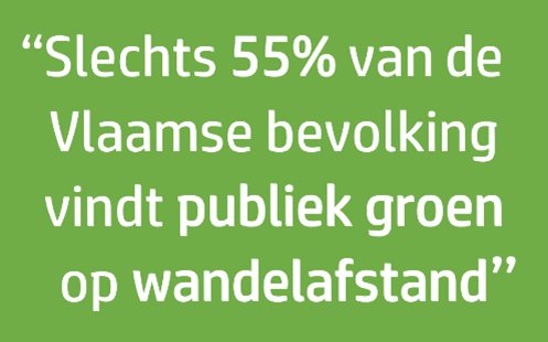
Wat blijkt uit de nieuwe index? Maar iets meer dan de helft (55%) van de Vlaamse bevolking vindt publiek groen op minder dan 10 minuten wandelen van hun woonplaats. In de centra van grote steden zoals Brugge, Gent, Antwerpen, Leuven en Hasselt worden de laagste cijfers behaald. Dit betekent dat er te weinig kwalitatief publiek groen is op de plaatsen waar de nood het grootst is. Het oosten van Vlaanderen scoort ook hier beter dan het westen, dat vooral uit landbouwvelden bestaat.
Waar kun je dan wel gezond wonen te midden van groen? Gemeenten zoals Genk, Mol, Oud-Heverlee en Zutendaal scoren gemiddeld heel goed op de index.
Kijk hieronder zelf eens hoe jouw omgeving scoort:
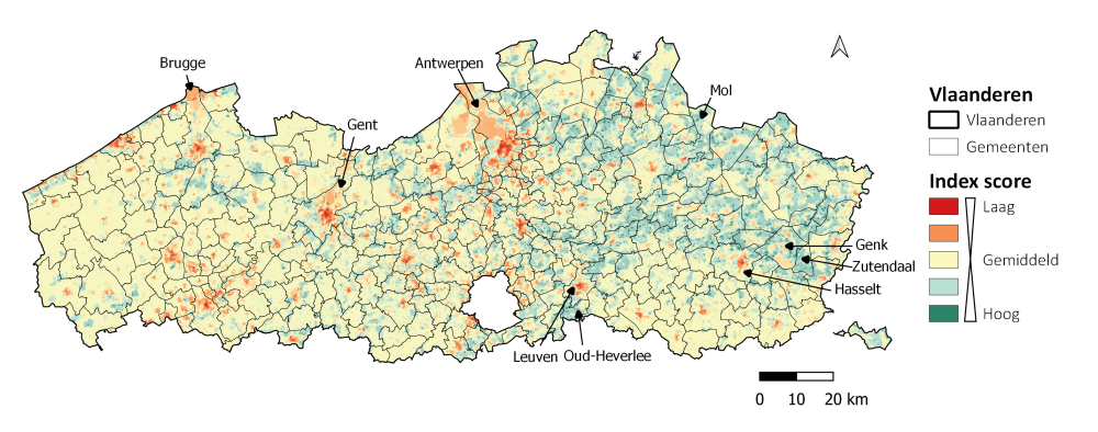
De toegankelijkheidsindex berekend voor de gemeenten van Vlaanderen
De index als gids voor groen beleid
De nieuwe groenkaart en index bieden niet alleen een schat aan gegevens, maar kunnen ook het startpunt zijn van concrete richtlijnen voor beleidsmakers, met specifieke focus op gebieden die dringend aandacht nodig hebben. Beleidsmakers kunnen met de tool gericht actie ondernemen in het plannen van nieuwe groene ruimtes en het aanpassen van bestaande. Bovendien kan de index worden aangepast aan specifieke lokale vereisten. Meer nog, zowel de kaart als de index hebben zelfs het potentieel om wereldwijd toegepast te worden.
Binnenkort wonen we allemaal in steden. De zoektocht naar toegankelijk groen in Vlaanderen werd voortgezet in deze scriptie en hieruit bleek: Vlaanderen is niet groen genoeg. Toch ligt een groenere en gezondere toekomst binnen handbereik. Met richtlijnen zoals deze index in handen, hebben beleidsmakers de nodige instrumenten om ons naar groenere oplossingen te leiden.
Nu is het tijd voor actie.
Bibliografie
Aerts, R., Honnay, O., & Van Nieuwenhuyse, A. (2018). Biodiversity and human health: mechanisms and evidence of the positive health effects of diversity in nature and green spaces. British Medical Bulletin, 127(1), 5–22. https://doi.org/10.1093/bmb/ldy021
Agentschap Digitaal Vlaanderen. (2017). Voorlopig referentiebestand gemeentegrenzen, toestand 17/08/2017 – correctie (Toestand 17/08/2017) [Dataset, Shapefile]. Retrieved from https://www.geopunt.be/catalogus/datasetfolder/463322e3-5041-4be4-8cb2-c495994ca217
Agentschap Digitaal Vlaanderen. (2021). Bodembedekkingskaart (BBK), 1m resolutie (opname 2018) [Dataset; Online]. Geopunt. https://www.geopunt.be/catalogus/datasetfolder/7e89f7df-8cca-4fd6-a954-735bcc6e7930
Agentschap Natuur en Bos. (2022). Groenkaart Vlaanderen 2021 [Dataset; Online]. Geopunt https://www.vlaanderen.be/datavindplaats/catalogus/groenkaart-vlaandere…
Aminal. (1993). Mens en Ruimte nv en Vereniging voor Openbaar Groen in opdracht van de Vlaamse Gemeenschap, 1993, Langetermijnplanning groenvoorziening, Ongepubliceerd rapport in opdracht van de afdeling Bos & Groen (Brussel)
Annerstedt van den Bosch, M., Mudu, P., Uscila, V., Barrdahl, M., Kulinkina, A., Staatsen, B., Swart, W., Kruize, H., Zurlyte, I., & Egorov, A. I. (2015). Development of an urban green space indicator and the public health rationale. Scandinavian Journal of Public Health, 44(2), 159–167. https://doi.org/10.1177/1403494815615444
Arnfield, A. J. (2003). Two decades of urban climate research: a review of turbulence, exchanges of energy and water, and the urban heat island. International Journal of Climatology, 23(1), 1–26. https://doi.org/10.1002/joc.859
Ballatore, A., Bertolotto, M., & Wilson, D. C. (2013). Geographic knowledge extraction and semantic similarity in OpenStreetMap. Knowledge and Information Systems, 37(1), 61–81. https://doi.org/10.1007/s10115-012-0571-0
Baptista, P., Pina, A., Duarte, G., Rolim, C., Pereira, G., Silva, C., & Farias, T. (2015). From on-road trial evaluation of electric and conventional bicycles to comparison with other urban transport modes: Case study in the city of Lisbon, Portugal. Energy Conversion and Management, 92, 10–18. https://doi.org/10.1016/j.enconman.2014.12.043
Barron, C., Neis, P., & Zipf, A. (2014). A Comprehensive Framework for Intrinsic OpenStreetMap Quality Analysis. Transactions in GIS, 18(6), 877–895. https://doi.org/10.1111/tgis.12073
Bertram, C., & Rehdanz, K. (2015). Preferences for cultural urban ecosystem services: Comparing attitudes, perception, and use. Ecosystem Services, 12, 187–199. https://doi.org/10.1016/j.ecoser.2014.12.011
Bolund, P., & Hunhammar, S. (1999). Ecosystem services in urban areas. Ecological Economics, 29(2), 293–301. https://doi.org/10.1016/S0921-8009(99)00013-0
Bosina, E., & Weidmann, U. (2017). Estimating pedestrian speed using aggregated literature data. Physica A: Statistical Mechanics and Its Applications, 468, 1–29. https://doi.org/10.1016/j.physa.2016.09.044
Botzat, A., Fischer, L. K., & Kowarik, I. (2016). Unexploited opportunities in understanding liveable and biodiverse cities. A review on urban biodiversity perception and valuation. Global Environmental Change, 39, 220–233. https://doi.org/10.1016/j.gloenvcha.2016.04.008
Bral, L., Jacques, A., Schelfaut, H., Stuyck, K., & Vanderhasselt, A. (2014). Stadsmonitor 2014. Een monitor voor leefbare en duurzame Vlaamse steden. Retrieved from https://gsminfo.gemeente-stadsmonitor.be/%24web/Documenten/stadsmonitor_editie_2014.pdf
Brander, L. M., & Koetse, M. J. (2011). The value of urban open space: Meta-analyses of contingent valuation and hedonic pricing results. Journal of Environmental Management, 92(10), 2763–2773. https://doi.org/10.1016/j.jenvman.2011.06.019
Bratman, G. N., Anderson, C. B., Berman, M. G., Cochran, B., de Vries, S., Flanders, J., Folke, C., Frumkin, H., Gross, J. J., Hartig, T., Kahn, P. H., Kuo, M., Lawler, J. J., Levin, P. S., Lindahl, T., Meyer-Lindenberg, A., Mitchell, R., Ouyang, Z., Roe, J., … Daily, G. C. (2019). Nature and mental health: An ecosystem service perspective. Science Advances, 5(7), eaax0903. https://doi.org/10.1126/sciadv.aax0903
Breheny, M. J. (1978). The measurement of spatial opportunity in strategic planning. Regional Studies, 12(4), 463–479. https://doi.org/10.1080/09595237800185401
Britannica, T. Editors of Encyclopaedia (2013, September 23). Leuven. Encyclopedia Britannica. https://www.britannica.com/place/Leuven
Britannica, T. Editors of Encyclopaedia (2022, September 14). urbanization. Encyclopedia Britannica. https://www.britannica.com/topic/urbanization
Britannica, T. Editors of Encyclopaedia (2023, January 26). Ghent. Encyclopedia Britannica. https://www.britannica.com/place/Ghent
Burgerbevraging Gemeente-Stadsmonitor, Agentschap Binnenlands Bestuur. (2020). Verplaatsingen vrije tijd: per vervoersmiddel ) [Dataset]. Gemeente-Stadsmonitor. https://gemeente-stadsmonitor.vlaanderen.be/indicators/verplaatsingen-v…
Calcaterra, E., Chan, L., Elmqvist, T., Hillel, O., Holman, N., Mader, A., & Werner, P. (2014). User’s Manual on the Singapore Index on Cities’ Biodiversity (also known as the City Biodiversity Index). National Parks Board, Singapore.
Carrus, G., Scopelliti, M., Lafortezza, R., Colangelo, G., Ferrini, F., Salbitano, F., Agrimi, M., Portoghesi, L., Semenzato, P., & Sanesi, G. (2015). Go greener, feel better? The positive effects of biodiversity on the well-being of individuals visiting urban and peri-urban green areas. Landscape and Urban Planning, 134, 221–228. https://doi.org/10.1016/j.landurbplan.2014.10.022
Chiesura, A. (2004). The role of urban parks for the sustainable city. Landscape and Urban Planning, 68(1), 129–138. https://doi.org/10.1016/j.landurbplan.2003.08.003
Crawford, D., Timperio, A., Giles-Corti, B., Ball, K., Hume, C., Roberts, R., Andrianopoulos, N., & Salmon, J. (2008). Do features of public open spaces vary according to neighbourhood socio-economic status? Health & Place, 14(4), 889–893. https://doi.org/https://doi.org/10.1016/j.healthplace.2007.11.002
Dadvand, P., Villanueva, C. M., Font-Ribera, L., Martinez, D., Basagaña, X., Belmonte, J., Vrijheid, M., Gražulevičienė, R., Kogevinas, M., & Nieuwenhuijsen, M. J. (2014). Risks and Benefits of Green Spaces for Children: A Cross-Sectional Study of Associations with Sedentary Behavior, Obesity, Asthma, and Allergy. Environmental Health Perspectives, 122(12), 1329–1335. https://doi.org/10.1289/ehp.1308038
Dalang O. (2022). TravelTime plugin (1.6.0) [QGIS plugin]. Retrieved from https://plugins.qgis.org/plugins/travel_time_platform_plugin/
Davison, K. K., & Lawson, C. T. (2006). Do attributes in the physical environment influence children’s physical activity? A review of the literature. International Journal of Behavioral Nutrition and Physical Activity, 3(1), 19. https://doi.org/10.1186/1479-5868-3-19
de Vries, S., van Dillen, S. M. E., Groenewegen, P. P., & Spreeuwenberg, P. (2013). Streetscape greenery and health: Stress, social cohesion and physical activity as mediators. Social Science & Medicine, 94, 26–33. https://doi.org/10.1016/j.socscimed.2013.06.030
Departement Landbouw en Visserij. (2021). Landbouwgebruikspercelen LV 2021 [Dataset; Geopunt]. (Version 30-03-2021). Digitaal Vlaanderen. https://www.vlaanderen.be/datavindplaats/catalogus/landbouwgebruiksperc…
European Environment Agency. (2022, April 1). Europe’s air quality status 2022. European Environment Agency. https://www.eea.europa.eu//publications/status-of-air-quality-in-Europe-2022
European Union. (2011). Mapping Guide for a European Urban Atlas.
Fan, P., Xu, L., Yue, W., & Chen, J. (2017). Accessibility of public urban green space in an urban periphery: The case of Shanghai. Landscape and Urban Planning, 165, 177–192. https://doi.org/10.1016/j.landurbplan.2016.11.007
Flanders Marine Institute. (2021). Global Oceans and Seas, version 1. Retrieved from https://www.marineregions.org/. https://doi.org/10.14284/542.
FME Community. (n.d.). FME [Software]. https://community.safe.com/s/documentation
Fox, K., Riddoch, C., & Editors, S. (2004). At Least Five A Week. Evidence on the Impact of Physical Activity and Its Relationship to Health. In At least five a week: evidence on the impact of physical activity and its relationship to health.
Fuller, R. A., Irvine, K. N., Devine-Wright, P., Warren, P. H., & Gaston, K. J. (2007). Psychological benefits of greenspace increase with biodiversity. Biology Letters, 3(4), 390–394. https://doi.org/10.1098/rsbl.2007.0149
GARMON. (2020). The Garden Monitor - mapping and characterizing gardens using remote sensing: final report. Belspo.
Gentin, S. (2011). Outdoor recreation and ethnicity in Europe—A review. Urban Forestry & Urban Greening, 10(3), 153–161. https://doi.org/10.1016/j.ufug.2011.05.002
Geofabrik downloads. (n.d.). OpenStreetMap Data Extracts. http://download.geofabrik.de/
Giles-Corti, B., Broomhall, M. H., Knuiman, M., Collins, C., Douglas, K., Ng, K., Lange, A., & Donovan, R. J. (2005). Increasing walking: How important is distance to, attractiveness, and size of public open space? American Journal of Preventive Medicine, 28(2, Supplement 2), 169–176. https://doi.org/10.1016/j.amepre.2004.10.018
Giuliani, G., Petri, E., Interwies, E., Vysna, V., Guigoz, Y., Ray, N., & Dickie, I. (2021). Modelling Accessibility to Urban Green Areas Using Open Earth Observations Data: A Novel Approach to Support the Urban SDG in Four European Cities. Remote Sensing, 13(3). https://doi.org/10.3390/rs13030422
Google. (n.d.). Google Street View [Street view image]. Retrieved from https://www.google.com/streetview/
Google. (2023). Google Satellite Images [Satellite image]. Retrieved from https://www.google.com/maps/space/satellite/
Gunnarsson, B., Knez, I., Hedblom, M., & Sang, Å. O. (2017). Effects of biodiversity and environment-related attitude on perception of urban green space. Urban Ecosystems, 20(1), 37–49. https://doi.org/10.1007/s11252-016-0581-x
Gupta, K., Roy, A., Luthra, K., Maithani, S., & Mahavir. (2016). GIS based analysis for assessing the accessibility at hierarchical levels of urban green spaces. Urban Forestry & Urban Greening, 18, 198–211. https://doi.org/10.1016/j.ufug.2016.06.005
Haaland, C., & Konijnendijk van den Bosch, C. (2015). Challenges and strategies for urban green-space planning in cities undergoing densification: A review. Urban Forestry & Urban Greening, 14(4), 760–771. https://doi.org/10.1016/j.ufug.2015.07.009
Haines-Young, R., & Potschin, M. (2018). Common International Classification of Ecosystem Services (CICES) V5.1 Guidance on the Application of the Revised Structure. http://www.cices.eu/
Harris, V., Kendal, D., Hahs, A. K., & Threlfall, C. G. (2018). Green space context and vegetation complexity shape people’s preferences for urban public parks and residential gardens. Landscape Research, 43(1), 150–162. https://doi.org/10.1080/01426397.2017.1302571
Harrison, C. M., Burgess, J., Millward, A., & Dawe, G. L. (1995). Accessible natural greenspace in towns and cities : a review of appropriate size and distance criteria : guidance for the preparation of strategies for local sustainability.
Hartig, T., Evans, G. W., Jamner, L. D., Davis, D. S., & Gärling, T. (2003). Tracking restoration in natural and urban field settings. Journal of Environmental Psychology, 23(2), 109–123. https://doi.org/10.1016/S0272-4944(02)00109-3
Hartig, T., Mitchell, R., de Vries, S., & Frumkin, H. (2014). Annual Review of Public Health. Nature and Health, 35, 1-497.
Heidt, V., & Neef, M. (2008). Benefits of Urban Green Space for Improving Urban Climate. Ecology, Planning, and Management of Urban Forests: International Perspectives, 84–96. https://doi.org/10.1007/978-0-387-71425-7_6
Heynen, N., Perkins, H. A., & Roy, P. (2006). The Political Ecology of Uneven Urban Green Space: The Impact of Political Economy on Race and Ethnicity in Producing Environmental Inequality in Milwaukee. Urban Affairs Review, 42(1), 3–25. https://doi.org/10.1177/1078087406290729
Instituut voor Natuur-en Bosonderzoek. (2020). Biologische Waarderingskaart, BWK22 (1-12-2020) [Dataset, Shapefile]. Retrieved from https://www.geopunt.be/download?container=bwk2\2020&title=Biologische%20waarderingskaart%20-%20Natura%202000%20Habitatkaart
ISO/TC 211. (2002). Geographic information—quality principles (International Organization for Standardization No. ISO 19113:2002). International Organization for Standardization (ISO).
Ives, C., Lentini, P., Threlfall, C., Ikin, K., Shanahan, D., Garrard, G., Bekessy, S., Fuller, R., Mumaw, L., Rayner, L., Rowe, R., Valentine, L., & Kendal, D. (2016). Cities are hotspots for threatened species. Global Ecology and Biogeography, 25, n/a-n/a. https://doi.org/10.1111/geb.12404
Jang, K. M., Kim, J., Lee, H.-Y., Cho, H., & Kim, Y. (2020). Urban Green Accessibility Index: A Measure of Pedestrian-Centered Accessibility to Every Green Point in an Urban Area. ISPRS International Journal of Geo-Information, 9(10). https://doi.org/10.3390/ijgi9100586
Janowiak, M. K., Brandt, L. A., Wolf, K. K., Brady, M., Darling, L., Lewis, A. D., Fahey, R. T., Giesting, K., Hall, E., Henry, M., Hughes, M., Miesbauer, J. W., Marcinkowski, K., Ontl, T., Rutledge, A., Scott, L., & Swanston, C. W. (2021). Climate adaptation actions for urban forests and human health. U.S. Department of Agriculture, Forest Service, Northern Research Station. https://doi.org/10.2737/nrs-gtr-203
Jansson, M., Fors, H., Lindgren, T., & Wiström, B. (2013). Perceived personal safety in relation to urban woodland vegetation – A review. Urban Forestry & Urban Greening, 12(2), 127–133. https://doi.org/10.1016/j.ufug.2013.01.005
Jiang, B., Claramunt, C., & Batty, M. (1999). Geometric accessibility and geographic information: extending desktop GIS to space syntax. Computers, Environment and Urban Systems, 23(2), 127–146. https://doi.org/10.1016/S0198-9715(99)00017-4
Jiang, B., Larsen, L., Deal, B., & Sullivan, W. C. (2015). A dose–response curve describing the relationship between tree cover density and landscape preference. Landscape and Urban Planning, 139, 16–25. https://doi.org/10.1016/j.landurbplan.2015.02.018
Jim, C. Y., & Chen, W. Y. (2006). Recreation–amenity use and contingent valuation of urban greenspaces in Guangzhou, China. Landscape and Urban Planning, 75(1), 81–96. https://doi.org/10.1016/j.landurbplan.2004.08.008
Jokar Arsanjani, J., Mooney, P., Zipf, A., & Schauss, A. (2015). Quality Assessment of the Contributed Land Use Information from OpenStreetMap Versus Authoritative Datasets. OpenStreetMap in GIScience: Experiences, Research, and Applications, 37–58. https://doi.org/10.1007/978-3-319-14280-7_3
Kabisch, N., Strohbach, M., Haase, D., & Kronenberg, J. (2016). Urban green space availability in European cities. Ecological Indicators, 70, 586–596. https://doi.org/10.1016/j.ecolind.2016.02.029
Kaczynski, A. T., & Henderson, K. A. (2007). Environmental Correlates of Physical Activity: A Review of Evidence about Parks and Recreation. Leisure Sciences, 29(4), 315–354. https://doi.org/10.1080/01490400701394865
Knobel, P., Maneja, R., Bartoll, X., Alonso, L., Bauwelinck, M., Valentin, A., Zijlema, W., Borrell, C., Nieuwenhuijsen, M., & Dadvand, P. (2021). Quality of urban green spaces influences residents’ use of these spaces, physical activity, and overweight/obesity. Environmental Pollution, 271, 116393. https://doi.org/10.1016/j.envpol.2020.116393
Kong, F., Yin, H., & Nakagoshi, N. (2007). Using GIS and landscape metrics in the hedonic price modeling of the amenity value of urban green space: A case study in Jinan City, China. Landscape and Urban Planning, 79(3), 240–252. https://doi.org/10.1016/j.landurbplan.2006.02.013
Konijnendijk, C. (2021, February 22). Promoting health and wellbeing through urban forests – Introducing the 3-30-300 rule | IUCN Urban Alliance. IUCN Urban Alliance. https://iucnurbanalliance.org/promoting-health-and-wellbeing-through-ur…
Konijnendijk, C. (2022). Evidence-based guidelines for greener, healthier, more resilient neighbourhoods: Introducing the 3–30–300 rule. Journal of Forestry Research. https://doi.org/10.1007/s11676-022-01523-z
Krenichyn, K. (2006). ‘The only place to go and be in the city’: women talk about exercise, being outdoors, and the meanings of a large urban park. Health & Place, 12(4), 631–643. https://doi.org/10.1016/j.healthplace.2005.08.015
Kumar, P. (2012). The Economics of Ecosystems and Biodiversity: Ecological and Economic Foundations (TEEB - The Economics of Ecosystems and Biodiversity) (1st ed.). Routledge. https://doi.org/10.4324/9781849775489
la Rosa, D. (2014). Accessibility to greenspaces: GIS based indicators for sustainable planning in a dense urban context. Ecological Indicators, 42, 122–134. https://doi.org/10.1016/j.ecolind.2013.11.011
Laan, C. M., & Piersma, N. (2021). Accessibility of green areas for local residents. Environmental and Sustainability Indicators, 10, 100114. https://doi.org/10.1016/j.indic.2021.100114
Lackey, N. Q., Tysor, D. A., McNay, G. D., Joyner, L., Baker, K. H., & Hodge, C. (2021). Mental health benefits of nature-based recreation: a systematic review. Annals of Leisure Research, 24(3), 379–393. https://doi.org/10.1080/11745398.2019.1655459
Larmet. V. (2022). _cppRouting: Algorithms for Routing and Solving the Traffic Assignment Problem_. R package version 3.1, <https://CRAN.R-project.org/package=cppRouting>. 1992
Le Texier, M., Schiel, K., & Caruso, G. (2018). The provision of urban green space and its accessibility: Spatial data effects in Brussels. PLOS ONE, 13(10), e0204684. https://doi.org/10.1371/journal.pone.0204684
Ling, K. (2021). A Look at Access to Green Space in Toronto Using the 3-30-300 Rule for Greener Cities.
Liu, S., & Zhu, X. (2004). Accessibility Analyst: An Integrated GIS Tool for Accessibility Analysis in Urban Transportation Planning. Environment and Planning B: Planning and Design, 31(1), 105–124. https://doi.org/10.1068/b305
Luber, G., & McGeehin, M. (2008). Climate Change and Extreme Heat Events. American Journal of Preventive Medicine, 35(5), 429–435. https://doi.org/10.1016/j.amepre.2008.08.021
Maas, J., Verheij, R. A., Spreeuwenberg, P., & Groenewegen, P. P. (2008). Physical activity as a possible mechanism behind the relationship between green space and health: A multilevel analysis. BMC Public Health, 8(1), 206. https://doi.org/10.1186/1471-2458-8-206
Maroko, A. R., Maantay, J. A., Sohler, N. L., Grady, K. L., & Arno, P. S. (2009). The complexities of measuring access to parks and physical activity sites in New York City: a quantitative and qualitative approach. International Journal of Health Geographics, 8(1), 34. https://doi.org/10.1186/1476-072X-8-34
Marselle, M. R., Hartig, T., Cox, D. T. C., de Bell, S., Knapp, S., Lindley, S., Triguero-Mas, M., Böhning-Gaese, K., Braubach, M., Cook, P. A., de Vries, S., Heintz-Buschart, A., Hofmann, M., Irvine, K. N., Kabisch, N., Kolek, F., Kraemer, R., Markevych, I., Martens, D., … Bonn, A. (2021). Pathways linking biodiversity to human health: A conceptual framework. Environment International, 150, 106420. https://doi.org/10.1016/j.envint.2021.106420
Millennium Ecosystem Assessment. (2005). Millennium Ecosystem Assessment: Current State & Trends Assessment, Volume 1. Island Press.
Neuvonen, M., Sievänen, T., Tönnes, S., & Koskela, T. (2007). Access to green areas and the frequency of visits – A case study in Helsinki. Urban Forestry & Urban Greening, 6(4), 235–247. https://doi.org/10.1016/j.ufug.2007.05.003
Nys, A. (2014). ‘Rapport Natuur op wandelafstand. Heeft elke Vlaming een natuurgebied op maximum 1,6 km van zijn woning?’ Rapport Natuurpunt, Mechelen
Ode Sang, Å., Knez, I., Gunnarsson, B., & Hedblom, M. (2016). The effects of naturalness, gender, and age on how urban green space is perceived and used. Urban Forestry & Urban Greening, 18, 268–276. https://doi.org/https://doi.org/10.1016/j.ufug.2016.06.008
Oksanen, J., Blanchet, F. G., Friendly, M., Kindt, R., Legendre, P., McGlinn, D., ... Wagner, H. (2021). vegan: Community Ecology Package. R package version 2.6-4. Retrieved from https://CRAN.R-project.org/package=vegan
OpenAI. (2021). GPT-3 Language Model. https://openai.com/blog/gpt-3-apps/
OpenStreetMap foundation. (n.d.). Copyright and License. OpenStreetMap. Retrieved April 21, 2022, from https://www.openstreetmap.org/copyright/en
OpenStreetMap Wiki. (n.d.). Map Features. https://wiki.openstreetmap.org/wiki/Map_features
Oxford University Press. (n.d.). Accessibility. In Oxford Learner’s Dictionaries (10th ed.). Oxford Learner’s Dictionary of Academic English. Retrieved April 26, 2022, from https://www.oxfordlearnersdictionaries.com/definition/english/accessibility?q=accessibility
Palliwoda, J., Kowarik, I., & von der Lippe, M. (2017). Human-biodiversity interactions in urban parks: The species level matters. Landscape and Urban Planning, 157, 394–406. https://doi.org/10.1016/j.landurbplan.2016.09.003
Pisman, A., Vanacker, S., Bieseman, H., Vanongeval, L., Van Steertegem, M., Poelmans, L., Van Dyck, K. (2021). Ruimterapport 2021. Departement Omgeving. Retrieved from https://publicaties.vlaanderen.be/view-file/47141
Poelman, H. (2018). A walk to the park? Assessing access to green in Europe’s cities - Update using completed Copernicus Urban Atlas data.
Poelmans, L., & van Rompaey, A. (2009). Detecting and modelling spatial patterns of urban sprawl in highly fragmented areas: A case study in the Flanders–Brussels region. Landscape and Urban Planning, 93(1), 10–19. https://doi.org/10.1016/j.landurbplan.2009.05.018
Poelmans, L., & Van Rompaey, A. (2010). Complexity and performance of urban expansion models. Computers, Environment and Urban Systems, 34(1), 17–27. https://doi.org/10.1016/j.compenvurbsys.2009.06.001
Poelmans, L., Janssen, L., & Hambsch, L. (2021). Land use and land take in Flanders, situation 2019. In omgevingvlaanderen.be. Flemish Planning Bureau for the Environment and Spatial Development. Retrieved April 5, 2023, from https://archief.onderzoek.omgeving.vlaanderen.be/Onderzoek-2530308
Polsby, D. D., & Popper, R. (1991). The Third Criterion: Compactness as a Procedural Safeguard Against Partisan Gerrymandering. SSRN Electronic Journal. https://doi.org/10.2139/ssrn.2936284
QGIS Development Team (2021). QGIS Geographic Information System. Open Source Geospatial Foundation Project. http://qgis.osgeo.org
Qiu, L., Lindberg, S., & Nielsen, A. B. (2013). Is biodiversity attractive?—On-site perception of recreational and biodiversity values in urban green space. Landscape and Urban Planning, 119, 136–146. https://doi.org/10.1016/j.landurbplan.2013.07.007
R Core Team (2021). R: A language and environment for statistical computing. R Foundation for Statistical Computing, Vienna, Austria. URL https://www.R-project.org/.
Raffler, C. (2020). QNEAT3 Plug-in (Version 1.0.4) [Software]. Available from https://plugins.qgis.org/plugins/QNEAT3/
Santamour, F. (1990). Trees for Urban Planting: Diversity, Uniformity and Common Sense. Proceedings of the 7th Conference of the Metropolitan Tree Improvement Alliance, 57–65.
Schipperijn, J., Ekholm, O., Stigsdotter, U. K., Toftager, M., Bentsen, P., Kamper-Jørgensen, F., & Randrup, T. B. (2010). Factors influencing the use of green space: Results from a Danish national representative survey. Landscape and Urban Planning, 95(3), 130–137. https://doi.org/10.1016/j.landurbplan.2009.12.010
Soga, M., & Gaston, K. J. (2016). Extinction of experience: the loss of human–nature interactions. Frontiers in Ecology and the Environment, 14(2), 94–101. https://doi.org/10.1002/fee.1225
Southon, G. E., Jorgensen, A., Dunnett, N., Hoyle, H., & Evans, K. L. (2018). Perceived species-richness in urban green spaces: Cues, accuracy and well-being impacts. Landscape and Urban Planning, 172, 1–10. https://doi.org/10.1016/j.landurbplan.2017.12.002
Stad Gent. (2022a). Dashboard Gent. Gent buurtmonitor. Retrieved April 26, 2022, from https://gent.buurtmonitor.be/dashboard/dashboard/bevolking
Stad Gent. (2022b). Parken-gent (n/a) [Dataset, Shapefile]. Retrieved from https://data.stad.gent/explore/dataset/parken-gent/export/
Stad Gent. (2022c). WoonWijkgroen versie 2019. Retrieved from Groendienst Departement Stedelijke Ontwikkeling
Stas, M., Aerts, R., Hendrickx, M., Delcloo, A., Dendoncker, N., Dujardin, S., Linard, C., Nawrot, T., van Nieuwenhuyse, A., Aerts, J.-M., van Orshoven, J., & Somers, B. (2021). Exposure to green space and pollen allergy symptom severity: A case-crossover study in Belgium. Science of The Total Environment, 781, 146682. https://doi.org/10.1016/j.scitotenv.2021.146682
Statbel. (2021). Built-up area. STATBEL Statitistics Flanders. Retrieved April 4, 2023, from https://www.vlaanderen.be/en/statistics-flanders/land-use/built-up-area
Statbel. (2022). Bevolking naar woonplaats, nationaliteit (Belg/niet-Belg), burgerlijke staat, leeftijd en geslacht. STATBEL België in Cijfers. Retrieved April 4, 2023, from https://bestat.statbel.fgov.be/bestat/crosstable.xhtml?view=5525fea5-4abb-424b-918c-d5a5658b9e34
Statistics Belgium. (2023). Statistische sectoren van België, meest recent (Toestand januari 2019, correctie 24/01/2022) [Dataset; Online]. Geopunt.
Stehman, S. V, & Czaplewski, R. L. (1998). Design and Analysis for Thematic Map Accuracy Assessment: Fundamental Principles. Remote Sensing of Environment, 64(3), 331–344. https://doi.org/10.1016/S0034-4257(98)00010-8
Stessens, P., Canters, F., Huysmans, M., & Khan, A. Z. (2020). Urban green space qualities: An integrated approach towards GIS-based assessment reflecting user perception. Land Use Policy, 91, 104319. https://doi.org/10.1016/j.landusepol.2019.104319
Sugiyama, T., & Ward Thompson, C. (2008). Associations between characteristics of neighbourhood open space and older people’s walking. Urban Forestry & Urban Greening, 7(1), 41–51. https://doi.org/10.1016/j.ufug.2007.12.002
Swetnam, R. D., Harrison-Curran, S. K., & Smith, G. R. (2017). Quantifying visual landscape quality in rural Wales: A GIS-enabled method for extensive monitoring of a valued cultural ecosystem service. Ecosystem Services, 26, 451–464. https://doi.org/10.1016/j.ecoser.2016.11.004
Takano, T., Nakamura, K., & Watanabe, M. (2002). Urban residential environments and senior citizens longevity in megacity areas: the importance of walkable green spaces. Journal of Epidemiology & Community Health, 56(12), 913–918. https://doi.org/10.1136/jech.56.12.913
Trimaille, E. (2022). (v.2.1.1). QGIS QuickOSM. https://plugins.qgis.org/plugins/QuickOSM/
Ulrich, R. S., Simons, R. F., Losito, B. D., Fiorito, E., Miles, M. A., & Zelson, M. (1991). Stress recovery during exposure to natural and urban environments. Journal of Environmental Psychology, 11(3), 201–230. https://doi.org/10.1016/S0272-4944(05)80184-7
UNECE (2022) Advancing sustainable urban and peri-urban forestry - a green approach to resilience, health, and green recovery. Policy brief. United Nations Economic Commission for Europe, Forests program, Geneva. Accessed 26 December 2022 from https://unece.org/forests/policy-briefs-forestry-and-timber-section
United Nations. (1992). Convention on Biological Diversity. Rio de Janeiro, Brazil. https://www.cbd.int/doc/legal/cbd-en.pdf
United Nations. (2022). The Sustainable Development Goals Report 2022. UN DESA.
United Nations. Departement of Economic and Social Affairs. (2019). World Urbanization Prospects 2018: Highlights. New York. Retrievedfrom https://population.un.org/wup/
United Nations Development Programme. (2022). Sustainable Development Goals. https://www.undp.org/Sustainable-Development-Goals.
United Nations General Assembly. (2015). Resolution adopted by the General Assembly on 25 September 2015
van den Berg, M., Wendel-Vos, W., van Poppel, M., Kemper, H., van Mechelen, W., & Maas, J. (2015). Health benefits of green spaces in the living environment: A systematic review of epidemiological studies. Urban Forestry & Urban Greening, 14(4), 806–816. https://doi.org/10.1016/j.ufug.2015.07.008
van Dillen, S. M. E., de Vries, S., Groenewegen, P. P., & Spreeuwenberg, P. (2012). Greenspace in urban neighbourhoods and residents’ health: adding quality to quantity. Journal of Epidemiology and Community Health, 66(6), e8. https://doi.org/10.1136/jech.2009.104695
Van Herzele, A., Wiedemann, T., & Van Overmeire, M. (2000). Milieu- en Natuurrapport Vlaanderen MIRA-S 2000 Leuven/Apeldoorn: Vlaamse Milieumaatschappij / Garant.
Van Herzele, A., & Wiedemann, T. (2003). A monitoring tool for the provision of accessible and attractive urban green spaces. Landscape and Urban Planning, 63(2), 109–126. https://doi.org/10.1016/S0169-2046(02)00192-5
Vandecasteele, A., & Devillers, R. (2015). Improving Volunteered Geographic Information Quality Using a Tag Recommender System: The Case of OpenStreetMap. OpenStreetMap in GIScience: Experiences, Research, and Applications, 59–80. https://doi.org/10.1007/978-3-319-14280-7_4
Verachtert, E., & Poelmans, L. (2022). Groentypologieën, toestand 2019 Technische beschrijving, rapport in opdracht van het Departement Omgeving. Departement Omgeving. Retrieved April 6, 2023, from https://archief-algemeen.omgeving.vlaanderen.be/xmlui/bitstream/handle/acd/768624/Groentypo_2019.pdf?sequence=1&isAllowed=y
Vlaamse Overheid – Departement Omgeving. (2022). Inwonersdichtheid per ha – Vlaanderen – Toestand 2019 (version 2022-06-2014) [Dataset]. Geopunt. https://www.vlaanderen.be/datavindplaats/catalogus/inwonersdichtheid-pe…
Vlaamse Overheid - Departement Omgeving - Afdeling Vlaams Planbureau voor Omgeving. (2023). Afbakeningen van de stedelijke gebieden in uitvoering van het Ruimtelijk Structuurplan Vlaanderen - toestand 2019 (Version 01/07/2019) [Dataset]. Geopunt. https://www.vlaanderen.be/datavindplaats/catalogus/afbakeningen-van-de-stedelijke-gebieden-in-uitvoering-van-het-ruimtelijk-structuurplan-vlaanderen-toestand-2019
Warburton, D. E. R., Nicol, C. W., & Bredin, S. S. D. (2006). Health benefits of physical activity: the evidence. CMAJ, 174(6), 801–809. https://doi.org/10.1503/cmaj.051351
Watkins, S. L., & Gerrish, E. (2018). The relationship between urban forests and race: A meta-analysis. Journal of Environmental Management, 209, 152–168. https://doi.org/10.1016/j.jenvman.2017.12.021
Wei, T., & Simko, V. (2021). corrplot: Visualization of a correlation matrix (Version 0.92) [Computer software]. Retrieved from https://github.com/taiyun/corrplot
Wheeler, B. W., Lovell, R., Higgins, S. L., White, M. P., Alcock, I., Osborne, N. J., Husk, K., Sabel, C. E., & Depledge, M. H. (2015). Beyond greenspace: an ecological study of population general health and indicators of natural environment type and quality. International Journal of Health Geographics, 14(1), 17. https://doi.org/10.1186/s12942-015-0009-5
Witlox, F., & Tindemans, H. (2004). Evaluating bicycle-car transport mode competitiveness in an urban environment: An activity-based approach. World Transport Policy & Practice, 10(4), 32-42.
World Health Organization. (2022). Urban health. https://www.who.int/europe/health-topics/urban-health
World Health Organization. Regional Office for Europe. (2016). Urban green spaces and health. World Health Organization. Regional Office for Europe. https://apps.who.int/iris/handle/10665/345751
Wulder, M. A., Franklin, S. E., White, J. C., Linke, J., & Magnussen, S. (2006). An accuracy assessment framework for large‐area land cover classification products derived from medium‐resolution satellite data. International Journal of Remote Sensing, 27(4), 663–683. https://doi.org/10.1080/01431160500185284
Yan, J., Zhou, W., & Jenerette, G. D. (2019). Testing an energy exchange and microclimate cooling hypothesis for the effect of vegetation configuration on urban heat. Agricultural and Forest Meteorology, 279, 107666. https://doi.org/10.1016/j.agrformet.2019.107666
Zhang, Y., Van Dijk, T., Tang, J., & Berg, A. E. van den. (2015). Green Space Attachment and Health: A Comparative Study in Two Urban Neighborhoods. International Journal of Environmental Research and Public Health, 12(11), 14342–14363. https://doi.org/10.3390/ijerph121114342
Zhang, Y., den Berg, A. E., Van Dijk, T., & Weitkamp, G. (2017). Quality over Quantity: Contribution of Urban Green Space to Neighborhood Satisfaction. International Journal of Environmental Research and Public Health, 14(5). https://doi.org/10.3390/ijerph14050535
Zhang, L., Tan, P. Y., & Richards, D. (2021a). Relative importance of quantitative and qualitative aspects of urban green spaces in promoting health. Landscape and Urban Planning, 213, 104131. https://doi.org/10.1016/j.landurbplan.2021.104131
Zhang, J., Yue, W., Fan, P., & Gao, J. (2021b). Measuring the accessibility of public green spaces in urban areas using web map services. Applied Geography, 126, 102381. https://doi.org/10.1016/j.apgeog.2020.102381
Zhou, X., & Parves Rana, M. (2012). Social benefits of urban green space. Management of Environmental Quality: An International Journal, 23(2), 173–189. https://doi.org/10.1108/14777831211204921
Zhou, W., Huang, G., Pickett, S. T. A., Wang, J., Cadenasso, M. L., McPhearson, T., Grove, J. M., & Wang, J. (2021). Urban tree canopy has greater cooling effects in socially vulnerable communities in the US. One Earth, 4(12), 1764–1775. https://doi.org/10.1016/j.oneear.2021.11.010
Zhou, Q., Wang, S., & Liu, Y. (2022). Exploring the accuracy and completeness patterns of global land-cover/land-use data in OpenStreetMap. Applied Geography, 145, 102742. https://doi.org/10.1016/j.apgeog.2022.102742